Lahemaa National Park
Lahemaa rahvuspark
Lääne-Virumaa / Harjumaa (Palmse / Käsmu) · Estonia
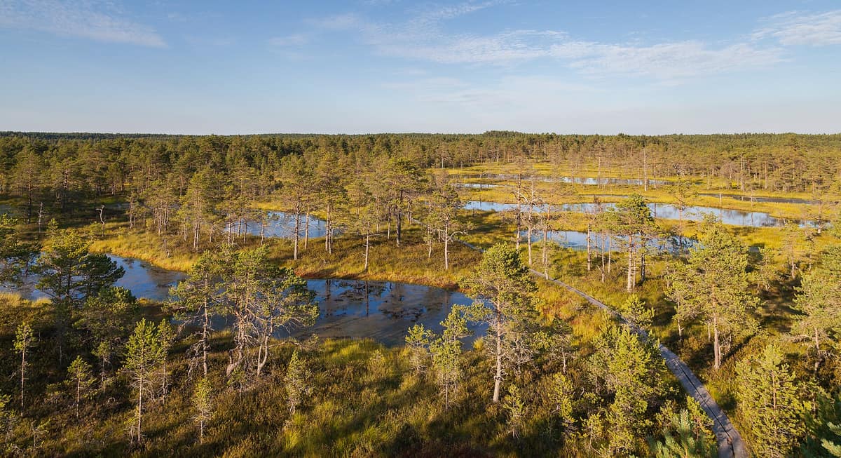
Photo: Diego Delso · CC BY-SA 3.0 · Wikimedia Commons
Estonia's oldest National Park (1971), protecting 4 Baltic peninsulas, boreal pine taiga, and the Viru bog.
In Lahemaa, the "land of bays", the Baltic Sea reaches deep into the boreal forest. Four major peninsulas—Juminda, Pärispea, Käsmu, and Vergi—are separated by four sweeping bays—Kolga, Hara, Eru, and Käsmu—framing an intricately indented Gulf of Finland coastline totaling around 145 km within the park. Located some 70 km east of Tallinn, this national park encompasses 747 km², including 274,9 km² of marine waters. It was established as the very first national park in the entire Soviet Union and remains Estonia's largest.
What makes it unique
Within a single park, bay-indented coasts, pine taiga covering over 70 percent of the land, and millennia-old raised bogs converge seamlessly.
The place
Nature
The landscape
A prominent geological feature is the North Estonian Klint, a limestone escarpment rising back from the coast. Inland, forest blankets the landscape: woodlands cover over 70 percent of Lahemaa, with Scots pine dominating roughly 60 percent of the territory. Nestled among these woods are expansive raised bogs, including the 7000-year-old Laukasoo peatland. Flowing waters carve valleys punctuated by four waterfalls: Turjekeldri, Vasaristi, Nõmmeveski, and Joaveski.
The coast preserves compelling historical heritage. Prior to 1991, the Soviet Navy operated a secret submarine degaussing base at Hara. The cultural landscape also features four historic manor estates: Palmse, Vihula, Kolga, and the baroque Sagadi manor.
Wildlife and seasons
The national park sustains robust populations of wild boar, red deer, grey wolf, brown bear, and Eurasian lynx. In the primeval forest of Oandu, visitors frequently encounter tracks of moose, boar, bears, and lynx, or occasionally glimpse the animals themselves. During summer, moose feed in flooded coastal meadows and willow thickets rich in aquatic vegetation.
Along rivers and streams, the Eurasian beaver has become the most conspicuous resident engineer. In the sheltered bays, the ringed seal represents the only marine mammal living year-round in these waters. On the avian calendar, common cranes gather each autumn along boulder-strewn headlands as a vital staging post on their migration toward the Bosphorus and Egypt.
Species
With a page in the atlas
Being mentioned in a source doesn't guarantee sightings: check with the people who manage the area.
Memory and protection
History and conservation
The national park was founded in 1971. Ongoing conservation prioritizes peatland hydrology: educational boards at the terminus of Viru Bog explain current ecological restoration across historic milling fields.
Before you set off
Visiting
How to visit
Two flagship State Forest Management Centre (RMK) trails capture the essence of the park: one traversing raised bog, the other winding through old-growth forest.
The Viru Bog trail measures 3,5 km, marked with green and white blazes on trees, and forms part of the long-distance Oandu-Aegviidu-Ikla hiking route. It can be completed as a circular walk: turning left at the end of the boardwalk onto the blue-dotted forest path yields a total loop of 5,5 km. The route incorporates 3 km of boardwalk, comprehensive interpretive boards, and an observation tower. Displays detail bog formation and specialized flora: Labrador tea, cloudberry, bog rosemary, hare's-tail cottongrass, and sundews. The far end features peat hollow pools and an actively restored former commercial extraction field with explanatory panels. Halfway along stands a covered shelter overlooking the expanse, and the observation tower is accessible via ramp for wheelchair and stroller users.
The Oandu old-growth trail covers 4,7 km through virgin forest. Lichen-clad fallen trunks lie strewn across the forest floor, where decaying wood provides habitat for rare fungi, mosses, and saproxylic beetles. Where canopy giants collapse, young spruce and deciduous saplings take root. The trail descends from dry lichen pine heath across the Koljaku-Oandu scarp into moist drained bog woodland fed by clear springs; ancient shoreline dunes support multi-generational stands of spruce, aspen, and alder, while upper slopes carry veteran Scots pines with deeply furrowed bark. Begin at the Oandu visitor centre exhibition "Path to the Virgin Forest", introducing the lifecycle of boreal woods. The path traverses wet sectors via boardwalks, equipped with benches, markers, and educational displays.
Before you go
In Viru Bog, stay strictly on the wooden boardwalk to protect fragile peat mosses and soft terrain, and never ride bicycles on the walkway. Despite standing water, dry summer bogs are highly combustible: a single spark on dried peat can trigger an uncontrollable underground fire. The top viewing platform of the tower holds up to 25 people simultaneously, and climbing is strictly forbidden during thunderstorms.
Check access, rules and visiting conditions in the official information from the managing body before you set off.
Location
Where it is and how far it reaches
Boundary of Lahemaa RP, Lahemaa pv. · IUCN VI · © EEA, CDDA (CC-BY) The coordinate is estimated; it isn't a verified access point.
Transparency
Sources
The research data with its sources, and the official links for this place, are in the Spanish version of this page. See the Spanish version
Entry #367 of the original atlas.