Semois Valley National Park
Parc National de la Vallée de la Semois
Province of Luxembourg (Bouillon / Vresse-sur-Semois) · Belgium / France
Photo: FrDr · CC BY-SA 4.0 · Wikimedia Commons
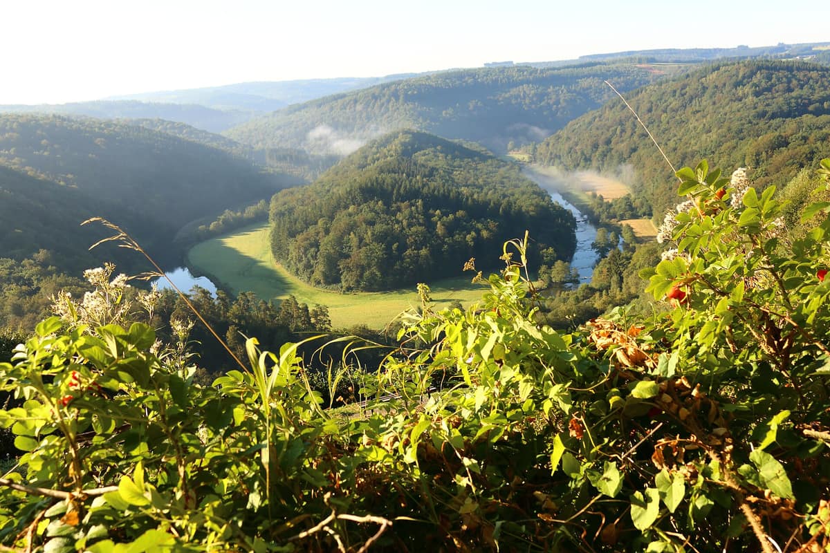
Incised meanders cut into Ardennes schists, including the giant meander of the "Tomb of the Giant".
A river that loops back on itself and, in the hollow of one of those loops, a hill covered in forest. That is the most iconic image of the Semois: the Tombeau du Géant, admired from a viewpoint at Botassart. The Semois, the "queen of meanders", crosses the Semois Valley National Park for 167 km, from Tintigny to Vresse-sur-Semois, and around it stretches a territory of ancient forests, wetlands and clean water. The Walloon Region designated it a national park on 9 December 2022.
What makes it unique
A river of meanders surrounded by ancient forest, with black storks, kingfishers and legends of Treviri warriors.
The place
Nature
The landscape
Water orders everything. Together with its tributaries, the territory totals about 690 km of watercourses.
After water comes the forest, which covers more than 86 % of the park. Most of it is broadleaf, 60 %, and ancient woodland, 65 %. Beyond the classic oak-beech woods there are slope forests (sycamore ravines, beech-luzula), riparian forests, hornbeam-oak woods and ash-oak woods.
Among the rarer habitats are tall-herb communities, lean hay meadows, wetlands and underground cavities left by the old slate-quarrying industry.
Wildlife and seasons
The inventory is impressive: 110 breeding bird species, 65 % of those of Wallonia; 20 bat species, of the 24 present in Wallonia; ten amphibian and six reptile species; 44 dragonfly and damselfly species. In the water live two rare and protected molluscs, the freshwater pearl mussel and the thick naiad.
The birds most easily associated with the river are the kingfisher, which nests in galleries on the soft banks of the Semois and may abandon its clutch if you pass too close; the white-throated dipper; the great egret, the goosander and the grey wagtail; and the black stork, alongside the black woodpecker. The eagle owl, the largest nocturnal raptor in the park, may desert its nest if repeatedly disturbed. The otter has been recorded again in the valley, and the park, together with WWF Belgium, is working to reinforce otter and lynx populations. The common viper and the viviparous lizard bask at forest edges.
The park calendar asks for respect at four moments. From February to July many species breed; from April to August birds nest; in September and October is the red deer rut — silence is requested; and from October to December is the hunting season, with signs and temporary access restrictions.
Species
With a page in the atlas
Being mentioned in a source doesn't guarantee sightings: check with the people who manage the area.
Memory and protection
History and conservation
The valley holds legends. One tells of a Treviri warrior of great stature who threw himself from the Rocher des Gattes to escape the Romans and was buried on the hill of the Tombeau du Géant. The Laforêt wicker bridge was used by tobacco growers, farmers and livestock.
Conservation focuses on the forest. Integral forest reserves let natural processes evolve without intervention, with restrictions on timber harvesting, hunting and access. The park aims to convert at least 10 % of its public broadleaf forests to that category, which would provide more shelter and food for bats, black and middle-spotted woodpeckers, and ease the eventual arrival of the lynx.
Before you set off
Visiting
How to visit
The territory has eight entry points, one per municipality, and the Destination Semois tool helps plan walks, cycling routes and horse rides. Local and river guides organise outings and can also be hired individually.
Four hides allow you to observe flora and especially fauna without disturbing it; they are at Vresse-sur-Semois, Poupehan, Herbeumont and Florenville. The Paysalia Interpretation Centre, in Florenville, helps you understand the valley landscapes.
Thematic trails are the best entry for those arriving without a plan. In the Defoy forest, near Paliseul, the "Dans la peau d'un blaireau" circuit covers 1.5 km and teaches, through panels and sensory activity huts, how a badger lives. The narrated route "De l'autre côté…" follows three kilometres of the Semois from the Chiny footbridge to the Moulin Cambier; on the Chiny trail, a sound story narrates the river birds. And there is a geology trail at La Roche à l'Appel, in Muno.
Must-see highlights include: the Moulin de l'Épine footbridge, opened in 2020, a 55 m suspension bridge near Bouillon; the Laforêt wicker bridge, about 80 m long, assembled and dismantled every year; the Ménil meanders, between Breuvanne and Termes, with panels about the fighting of August 1914; the Jambon viewpoint, between Membre and Bohan, with an overhead view of the Semois 120 m below; and the Domaine des Épioux, more than 1,700 ha between Chiny and Herbeumont, with five ponds and varied woodland.
Before you go
The park asks you to respect breeding seasons: avoid disturbing birds between February and July, stay silent during the red deer rut in September and October, and pay attention to temporary access restrictions during the hunting season from October to December. Near nesting sites of eagle owls and black storks, keep your distance. Stay on marked paths near the eagle owl nests and never approach the kingfisher's bank galleries.
Check access, rules and visiting conditions in the official information from the managing body before you set off.
Location
Where it is and how far it reaches
Boundary of Zones nodales du parc national de la Vallée de la Semois · IUCN II · © EEA, CDDA (CC-BY) The coordinate is estimated; it isn't a verified access point.
Transparency
Sources
The research data with its sources, and the official links for this place, are in the Spanish version of this page. See the Spanish version
Around it
Right next to the park is the Plateau de la Croix-Scaille – Massé; about 5 km away, the Grande Forêt de Saint-Hubert; and about 10 km away, the Forêt d'Anlier.
What else to explore nearby
Approximate straight-line distance between the edges of each area. It doesn't indicate access, routes or driving times.
- Anlier Forest
Belgian Luxembourg (Habay / Habay-la-Neuve)
About 10 km away
One of the most extensive contiguous beech forests in Belgium, safeguarding the headwater rivers of the Ardennes massif.
JFMAMJJASONDMay – October · Crowding very low
Entry #378 of the original atlas.