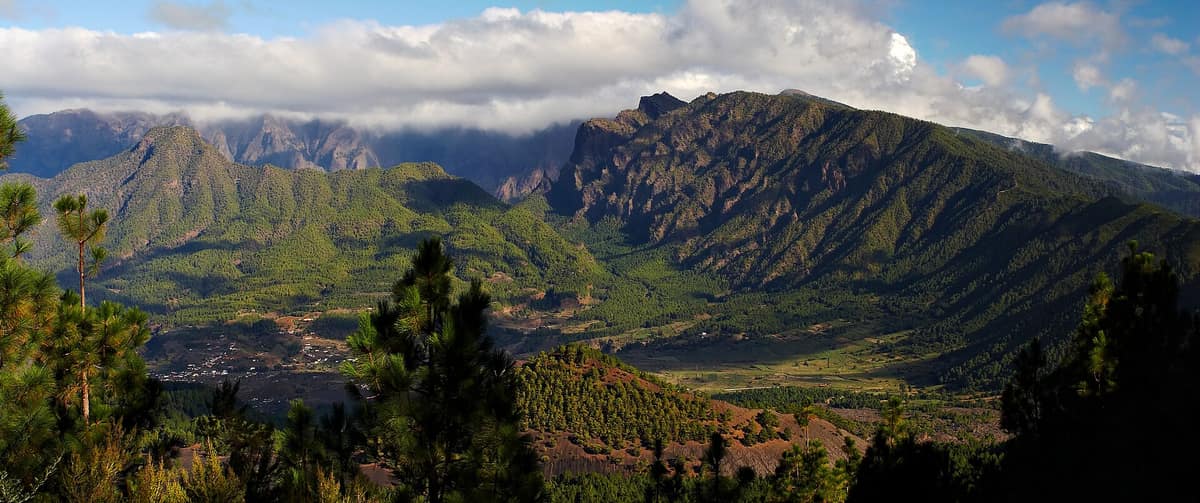
Caldera de Taburiente National Park
Parque Nacional de la Caldera de Taburiente
Canary Islands (La Palma / El Paso / Los Llanos de Aridane) · Spain
Photo: Michael Apel · CC BY-SA 3.0 · Wikimedia Commons
A colossal volcanic erosion cirque 8 km in diameter and 1,500 m deep, rimmed by precipitous Canary Island pine forests (Pinus canariensis).
Picture a vast rock amphitheatre whose tiered crests reach 2426 metres, plunging down to a caldera floor resting between 600 and 900 metres above sea level. This is the Caldera de Taburiente at the heart of La Palma, crowned by the Roque de los Muchachos as its highest point, where the international astrophysical observatory stands. Its sole natural drainage outlet is the Barranco de las Angustias gorge, where the Taburiente and Almendro Amargo watersheds converge to reach the Atlantic. It has been a national park since 1954.
What makes it unique
A caldera that preserves its water, pine woodlands and endemic flora thanks to more than four hundred years of community water conservation.
The place
Nature
The landscape
Water rules this mountain sanctuary. Around 1,800 landholders tap the pure mountain flow from over 70 natural springs and gallery adits across the Caldera, protected by ancestral bylaws of the Heredamiento de las Haciendas de Argual y Tazacorte that strictly banned felling trees and introducing livestock. Born over 400 years ago, this early conservation ethos enabled the Caldera to reach modern times with its ecosystems remarkably intact. The Almendro Amargo stream runs ochre-red from iron minerals, while the Cascada de Colores displays vivid mineral greens and oranges where mosses thrive amid ferruginous seepages. Interior monoliths, known as roques, are now understood as sedimentary breccias formed by catastrophic volcanic debris avalanches.
Vegetation is zoned in altitudinal belts. Along the floor and lower slopes dominates the endemic Canary Island pine, accompanied by amagante rockroses; the pine withstands periodic wildfires through thick protective bark that shields living inner tissues. In humid gullies, laurel-forest elements such as faya and tree heath trap oceanic trade-wind mist. Precipitous cliff faces harbour specialized rupicolous flora, including houseleek succulents of Aeonium and Greenovia. Higher up, above 1700 metres, alpine scrub takes over with yellow broom, Canary cedar, summit pansy, blue bugloss and mountain dock. The Caldera encompasses 380 catalogued vascular plant species.
Wildlife and seasons
Macaronesian endemic avifauna features the white-tailed laurel pigeon, Atlantic canary, Berthelot's pipit and plain swift. The red-billed chough, known locally as the graja, is frequently spotted soaring across high crags. Three bat species reside here, notably the Madeira pipistrelle and Canary big-eared bat, while reptiles include the western Canaries lizard and Delande's gecko. At an altitude of 2000 metres lies a lava cave sheltering a blind, unpigmented subterranean beetle endemic to La Palma.
The principal ecological threat comes on four hooves: introduced Barbary sheep, feral goats and rabbits that browse vulnerable endemic plants. Enclosed fenced plots have been constructed to encourage regeneration and seed gathering, alongside targeted monitoring of mountain broom and the summit violet underway since 1988. Conservation programmes seek to restore the vegetation patterns that predated human arrival slightly more than 2000 years ago.
Species
With a page in the atlas
Being mentioned in a source doesn't guarantee sightings: check with the people who manage the area.
Memory and protection
History and conservation
In pre-Hispanic times, the Caldera formed the indigenous cantón of Aceró, led by its legendary mencey Tanausú. It was a seasonal refuge for goat herds during low-elevation droughts; in the Barranco de Tajodeque, cave shelters hold geometric engravings resembling ancient Berber scripts. Due to rugged topography, the Caldera remained largely unsettled, used solely for goat pastoralism and subsequently water harvesting. The national park was created by decree in 1954 following advocacy by artists and scientists.
Before you set off
Visiting
How to visit
All travel within the national park is on foot. The El Paso visitor centre is the logical gateway: it features interpretive halls covering volcanology, hydrology and plant life, complemented by an outdoor botanical garden of Canarian endemics. From here, a 7 km mountain road winds to the La Cumbrecita viewpoint, the most visited outlook, where vehicle access is regulated in the morning due to limited parking. Los Brecitos is accessible via an unpaved forest track by car for sightseeing, though parking is strictly forbidden. The summit lookout at Roque de los Muchachos crowns the park and island, accessible via high-altitude roads without scheduled public transport.
The quintessential hike is the Los Brecitos to Caldera circuit, a challenging 12.5 km trek taking around six hours descending through towering pine groves into the abyss. Other routes explore the campsite to Barranco de las Angustias gorge with pillow lavas and iron waterfalls; the climb up Pico Bejenado across corded pahoehoe lavas; and high traverses from Roque de los Muchachos overlooking the sea of clouds.
Before you go
Always hike accompanied, keep strictly to marked trails, avoid starting descents in late afternoon, and avoid the park during heavy rain or high winds due to severe rockfall risk. The trail connecting La Cumbrecita to the camping area is exposed and hazardous, subject to seasonal landslides: check its status at the visitor centre beforehand. Camping requires a mandatory advance permit obtained at the El Paso visitor centre.
Check access, rules and visiting conditions in the official information from the managing body before you set off.
Location
Where it is and how far it reaches
Boundary of La Caldera de Taburiente · IUCN II · © EEA, CDDA (CC-BY) The coordinate is estimated; it isn't a verified access point.
Transparency
Sources
The research data with its sources, and the official links for this place, are in the Spanish version of this page. See the Spanish version
Entry #645 of the original atlas.