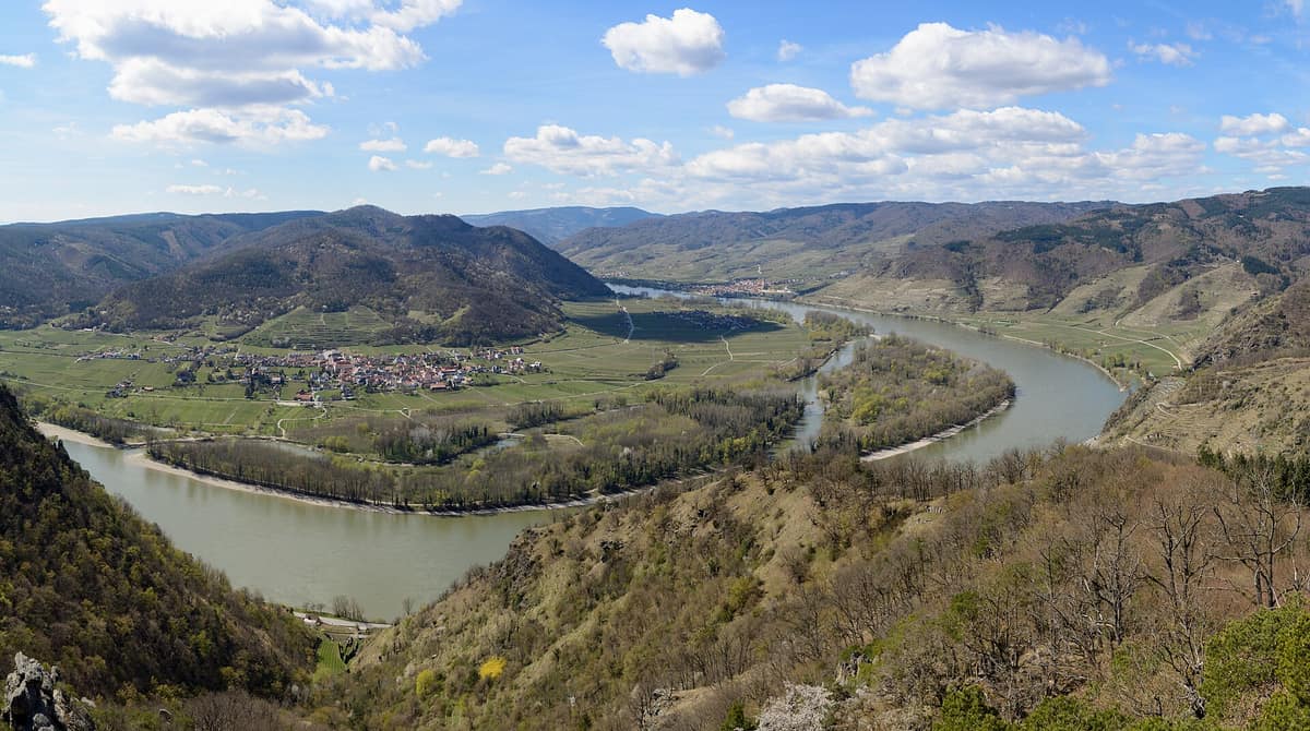
Wachau Valley - Natural River Stretches
Wachau - Tramos naturales
Lower Austria (Melk / Krems) · Austria
Photo: Uoaei1 · CC BY-SA 4.0 · Wikimedia Commons
Danube gorge flanked by terraced slopes, thermophilic oak woods, and crags.
When a river confronts a bedrock massif, it has two choices: bypass it or slice straight through. The Danube cut through. Over some 35 kilometres between Melk and Krems it carves across the southern tip of the Bohemian Massif, flanking both sides with a steep gorge where the valley bottom, at roughly 200 metres, enjoys a benign microclimate while surrounding summits reaching 900 face freezing winters. That contrast shapes everything: dry-stone vineyard terraces, steppe grasslands, downy oak woods, and an undammed river running wild. UNESCO inscribed the cultural landscape in 2000, embracing Melk and Göttweig Abbeys alongside Krems historic core.
What makes it unique
A stretch of the Danube saved from damming: here the river still runs free among gravel banks, islands, and side arms.
The place
Nature
The landscape
The highest summits are the Jauerling at 960 metres and the Sandl at 723. The hillsides are sculpted with dry-stone agricultural terraces; these stone dry-walls and sunny steppe grasslands constitute the signature habitat of the Wachau.
The Danube itself is the other master force. Because it is a narrow antecedent gorge, vast floodplains never formed: across the entire World Heritage area only 239 hectares of riparian forest survive. Consequently, every relic parcel is invaluable, and restored side arms assume paramount importance.
Dry grasslands cluster around Spitz, St. Michael, Dürnstein, Rossatz, and Krems. The largest expanse in the eastern gorge is the Höhereck above Dürnstein, harboring around 200 plant species and close to 100 butterfly species. On sun-drenched upper slopes thrive open thermophilic woodlands of downy oak, an endangered habitat across Europe, notably around the Teufelsmauer in Spitz.
Wildlife and seasons
Dry-stone retaining walls harbor the green lizard, the living emblem of the Wachau, thriving between 125 and 600 metres on warm slopes alongside the Aesculapian snake, one of Europe's largest snakes, reaching up to 2 metres and completely harmless to humans. The dry pastures shelter the praying mantis, still widespread here despite declines across Lower Austria, and the European ground squirrel (Ziesel), severely endangered in Austria yet holding dense colonies near Krems and Mautern. European wildcat sightings are increasingly confirmed, a carnivore once deemed extirpated in the country.
Upward on cliffs and forested bluffs reside peregrine falcon, black stork, Eurasian eagle-owl, common kingfisher, and Eurasian hoopoe; European bee-eater and white-tailed eagle are regular visitors. In mature deciduous stands such as the Steinige Ries near Rossatz breeds the elusive white-backed woodpecker. The region is designated as one of Austria's 58 Important Bird Areas. The river yields over 50 fish species, including the endangered Huchen and common nase, along with Eurasian beaver and Eurasian otter.
The seasons establish a vivid rhythm. Almond trees flower in late February, followed two weeks later by apricot blossoms in mid-April, heralding peak spring. Hoopoes and woodlarks return simultaneously. Migratory bee-eaters hunt from early May through late August. Late spring brings burnt and military orchids, while autumn sees departing birds of passage. Rare Brillenschaf sheep graze the dry meadows of Dürnstein (Kuhberg and Kellerberg) and Setzberg in Spitz to halt shrub encroachment.
Species
With a page in the atlas
Being mentioned in a source doesn't guarantee sightings: check with the people who manage the area.
Memory and protection
History and conservation
Settlement in the Wachau dates deep into prehistory: the Venus of Willendorf was unearthed here, the oldest known artistic remnant of humanity in the valley. In Roman antiquity, the Danube formed the northern Imperial frontier (Limes), guarded by the legionary fortress Favianis at present-day Mautern. Medieval barons of the Kuenring family dominated the gorge from castles at Aggstein and Dürnstein.
In the early nineteen-seventies, engineers designed a major hydroelectric dam at Rossatz. Resolute public opposition blocked the project, and in 1983 it was permanently cancelled, ensuring the Danube remained undammed here. In 2006, the side channel originally planned for the power canal was reconnected to the river for ecological restoration.
The Wachau has been protected as a landscape reserve since 1955, was awarded the European Diploma of Protected Areas in 1994, and incorporates the Jauerling-Wachau Nature Park established in 1972. The LIFE Auenwildnis project revived backwaters and riparian woods: digging 43 breeding pools for Danube crested newts and yellow-bellied toads, and from the 600 surviving veteran native black poplars, over 5000 young trees have been planted. BirdLife erected five artificial nesting platforms for white-tailed eagles, sparking the first breeding attempts in nearly a century. Volunteers mow between 5 and 10 hectares of dry grasslands annually.
Conservation networks
Before you set off
Visiting
How to visit
For floodplain woods, the finest excursion is the Pritzenau near Rossatz. The trail sets out from the sports ground car park, steps from the Danube Cycle Path, venturing into the alluvial forest along broad, flat paths. A wooden boardwalk spans a side arm, where patient walkers spot kingfishers, herons, and beavers.
For panoramic hiking, the Welterbesteig Wachau spans 180 km, linking the 13 World Heritage municipalities along both riverbanks; Krems serves as an ideal base.
Before you go
Spring, with its orchard blossoms, and autumn are the finest seasons to visit.
Check access, rules and visiting conditions in the official information from the managing body before you set off.
Location
Where it is and how far it reaches
Boundary of Jauerling-Wachau · IUCN V · © EEA, CDDA (CC-BY) The coordinate is estimated; it isn't a verified access point.
Transparency
Sources
The research data with its sources, and the official links for this place, are in the Spanish version of this page. See the Spanish version
Around it
The atlas lists no immediate neighbors for Wachau. The Elbe Sandstone River Corridor is a distant counterpart sharing eagle-owls, canyon topography, and free-flowing river corridor dynamics.
Entry #202 of the original atlas.