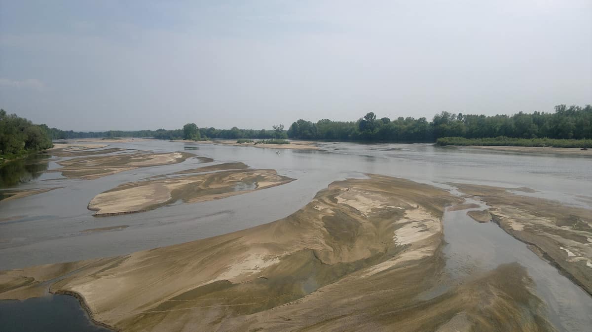
Wild Loire and Alluvial Loire Islands
Loire Sauvage & Loire Alluvial Islands
Burgundy-Franche-Comté / Centre-Val de Loire (Nevers / Cosne) · France
Photo: Magallanes · CC BY-SA 3.0 · Wikimedia Commons
The longest and wildest lowland river in France, featuring dynamic sandbars and islands of spontaneous riparian vegetation.
A river of braided channels, ephemeral islands and gravel bars that never stand still. The Loire is celebrated as one of Europe's last wild rivers, and the Val de Loire National Nature Reserve, at the exact midpoint of its course, demonstrates why: 19 km of riverway, 1,454 hectares of active channel, gravel islands and riparian shores between Nièvre and Cher, where the current constantly carves side branches and shifting gravel bars. It represents the quintessential stretch of the middle Loire, the 450 km flowing between Nevers and Angers.
What makes it unique
Here the river still reigns: it rises, falls, meanders and reshapes its islands, with each shifting phase supporting its own wildlife.
The place
Nature
The landscape
The reserve is sculpted entirely by fluvial dynamics. Continuous sediment transport lends the riverbed its braided morphology, with islands, shingle beaches and secondary channels continually created and rebuilt. Midway between headwaters and the Atlantic Ocean—at Pouilly, the Loire reaches the exact halfway point of its long journey—the result is an intricate mosaic: open channels, sand spits, wooded islands, oxbows, seasonal pools, marshlands, gallery woodland, dry alluvial grasslands and scrub, all shaped by flood surges and summer low water. In all, some twenty distinct habitat types are present.
Each river zone develops its own flora. On open shingle bars conditions are extreme: submerged for much of the year, surface temperatures soar to 50 °C in midsummer, providing habitat for common fleabane. Higher on the banks alluvial woodland takes hold, with white willows and black poplars along the lower shoreline and, further up, ash, elm and pedunculate oak, interspersed with bushy shrub willows known locally as 'verdiaux'.
Wildlife and seasons
Life revolves around the river terns. In spring, common terns and little terns return from African wintering grounds to breed on gravel islands; the Little tern and common tern lay eggs directly on the shingle, seamlessly camouflaged against pebbles alongside little ringed plovers and Eurasian stone-curlews. For this reason access to key sandbars is closed during the nesting season.
Along eroded riverbanks, the Common kingfisher, sand martin and European bee-eater excavate nesting burrows in soft sandy bluffs. In total over 220 bird species have been recorded, nearly a hundred of them breeding locally. The main channel functions as a vital migratory corridor for the Atlantic salmon, the European eel, allis shad and sea lamprey.
In quiet side arms known locally as 'boires', the current slows, warming in shallower water. Here lives the Eurasian beaver, felling willows and poplars to feed on tender bark and block lodge entrances, alongside diverse aquatic insects and amphibians like the natterjack toad. The reserve records 43 fish species, 12 reptiles, 11 amphibians, 42 dragonflies and damselflies, and 380 butterflies.
Species
With a page in the atlas
Being mentioned in a source doesn't guarantee sightings: check with the people who manage the area.
Memory and protection
History and conservation
The reserve was established by ministerial decree on 21 November 1995, recognizing the long-standing ecological and landscape value of this stretch where active fluvial dynamics remain untamed. Today it is co-managed by two regional conservancies, the Conservatoire d'espaces naturels de Bourgogne and that of Centre-Val de Loire. A management committee of local elected officials, authorities, river users and scientists guides strategic action.
Some 130 species present are categorized as threatened to varying degrees, with the reserve bearing strong conservation responsibility for 48 of them. Since late 2014, the conservancies and Past'horizons have coordinated seasonal targeted sheep grazing across riparian meadows. Land ownership is divided between 72 % State-owned public river domain, 3 % municipal land and 25 % private plots.
Before you set off
Visiting
How to visit
The reserve offers three discovery trails. The middle Loire paths start from the Pavillon du milieu de Loire, located at 17 quai Jules Pabiot in Pouilly-sur-Loire, featuring an island trail that explores a river system in constant evolution. The other two trails set out from La Charité-sur-Loire and Les Saulières in Herry. All three offer interpretive booklets, with guided nature walks arranged by the reserve and the Pavillon.
If you prefer the water, management provides downloadable guide sheets for exploring the reserve by canoe, while a traveling exhibition showcases river biodiversity for public events and school outreach. In addition, numerous public footpaths along the Loire banks offer convenient walking access to the reserve.
Before you go
Walking, horse riding and cycling are welcome on public ways, but motorized vehicles are strictly banned off open public roads, alongside camping, fires and waste dumping. Dogs are prohibited, and access to key gravel islands is restricted seasonally to safeguard nesting terns. The recommended visiting season runs from May to September.
Check access, rules and visiting conditions in the official information from the managing body before you set off.
Location
Where it is and how far it reaches
Boundary of Val De Loire · IUCN IV · © EEA, CDDA (CC-BY) The coordinate is estimated; it isn't a verified access point.
Transparency
Sources
The research data with its sources, and the official links for this place, are in the Spanish version of this page. See the Spanish version
Around it
The Reserva Natural del Valle del Allier shares with the Loire valley the little tern and Eurasian beaver, forming another vital braided river and wetland corridor.
If you like this place, elsewhere in Europe
Distant places with uncommon wildlife and habitats in common. The most widespread species don't count. Sharing species doesn't imply a corridor or guaranteed presence.
- Val d’Allier Nature Reserve
Auvergne-Rhône-Alpes (Allier / Moulins)
In common: Little tern · Eurasian beaver — river corridor, wetland
One of Western Europe’s last truly wild, free-flowing lowland rivers without artificial embankments.
JFMAMJJASONDMay – September · Crowding very low
Entry #190 of the original atlas.