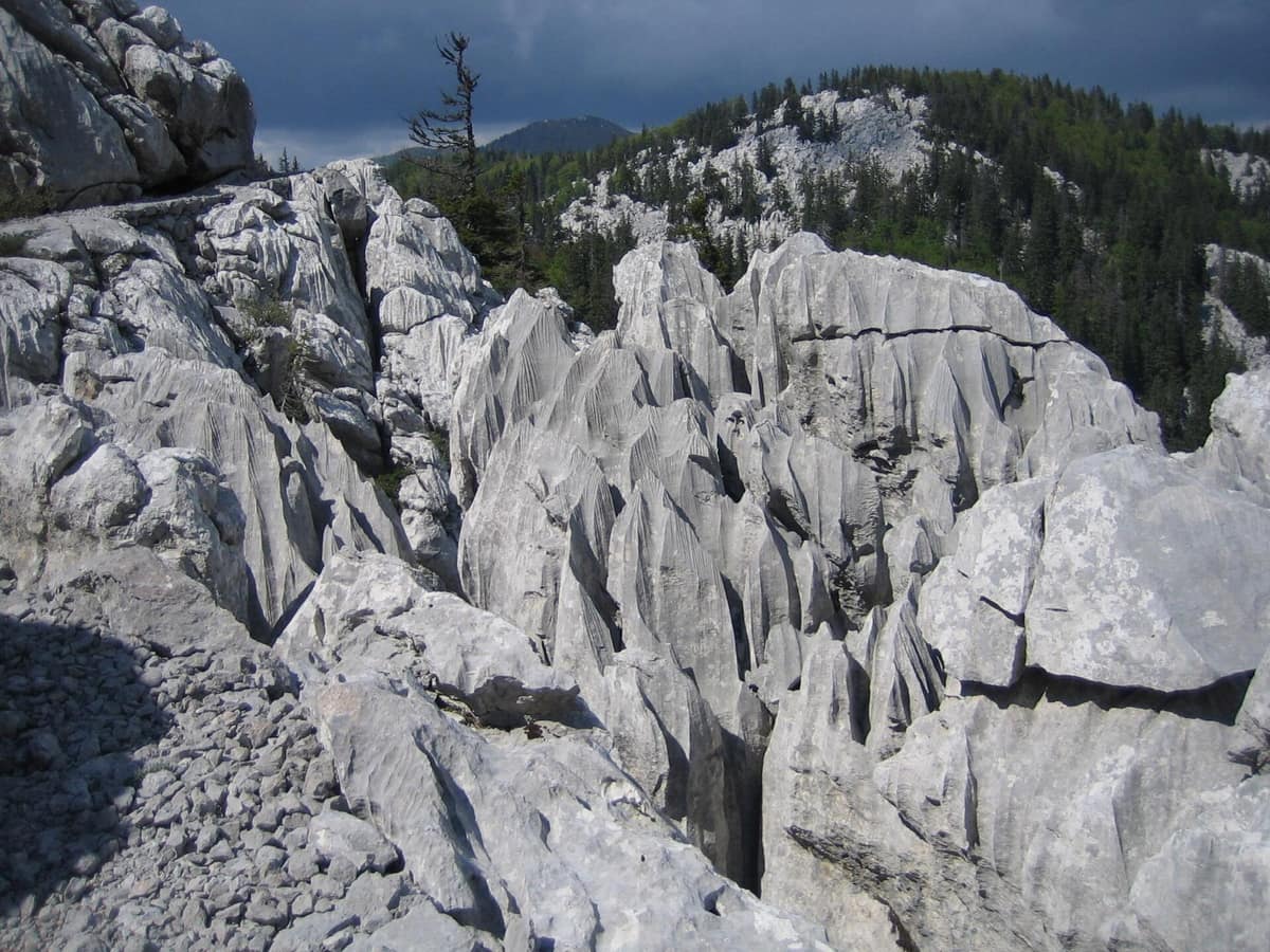
Northern Velebit National Park
Nacionalni park Sjeverni Velebit
Lika-Senj (Croatia) · Croatia
Photo: Rootmaker · CC BY-SA 3.0 · Wikimedia Commons
Karst relief, ancient beech forests and mountain pastures in Northern Velebit.
There are mountains you look at and mountains you traverse, and northern Velebit belongs to the latter. A dry-stone footpath, constructed between 1930 and 1933 so that anyone could venture into the wildest section of the massif, crosses the park from shelter to shelter, surrounded by a mosaic of beech woods, pastures, rocky crags and vertical caves. Sjeverni Velebit National Park, the youngest of the eight in Croatia, was established in 1999 across 109 km² that stretch from 518 to 1676 m in altitude.
What makes it unique
Here grow primeval beech forests on karst, with stunted and twisted silhouettes, which UNESCO inscribed on the World Heritage list in 2017, and beneath them opens a labyrinth of vertical caves, three of them over 1000 metres deep.
The place
Nature
The landscape
Everything began beneath the sea, 310 million years ago. The massif was uplifted during tectonic folding that started around 40 million years ago, eventually rising above 1700 m. The outcome is a limestone topography where rainwater vanishes into chasms and dolines: around 500 subterranean formations are documented, 98 % of them vertical shafts, and three exceed 1000 metres in depth. The pinnacles of Hajdučki i Rožanski kukovi, at the heart of the park, are the finest example, and their access is strictly restricted to researchers and educational parties.
More than 80 % of the park is forested, arranged in distinct vegetation tiers according to altitude. If you ascend from the sea along the coastal flank, you first cross pubescent oak and hornbeam woods, and the forest shifts as elevation increases. The pastures bear the imprint of traditional grazing; once livestock disappears, shrubs and pioneer forest gradually reclaim them.
The flora features more than 950 plant species and subspecies, including about 40 strict endemics. The Velebit is one of four major centres of plant endemism in Croatia, as cold-adapted glacial relics remained isolated upon these ridges after the retreat of the ice sheets.
Wildlife and seasons
These vast, well-preserved woodlands provide habitat for the three large European carnivores: brown bear, wolf and lynx, clear evidence of a thriving ecosystem. The Eurasian lynx, extirpated in Croatia in the early twentieth century, returned from Slovenia, where it was reintroduced in 1973, and crossed back into Croatia one year later. Among the most frequent herbivores and mammals are roe deer, red deer, chamois and wild boar.
For birdlife, you must scan both canopy and sky. The capercaillie finds here one of its few remaining strongholds in Croatia, observed most frequently along forestry tracks and mountain paths when wild berries ripen. Other notable birds include the pygmy owl, boreal owl, eagle owl, Ural owl, three-toed woodpecker, white-backed woodpecker and golden eagle.
Deep subterranean realms shelter the Velebit leech, strictly endemic to northern Velebit: it was discovered in 1992 inside the Lukina jama abyss and inhabits only four deep vertical shafts across the park.
The mountain calendar is dictated by weather. Near Zavižan, the first snowfall typically arrives in mid-October and the final snow melts in late May; the Zavižan meteorological observatory, at 1594 m, is the highest in Croatia and has operated continuously since 1 October 1953. Most flora in the botanical garden blooms during June and July, and the regular visitor season runs from May through November.
Memory and protection
History and conservation
Construction of the Premužić Trail commenced in 1930 and finished in the summer of 1933. During peak summer, the influx of hikers along the Premužić route can diminish the sense of pristine wilderness.
The park incorporates earlier conservation reserves: the strict nature reserve of Hajdučki i Rožanski kukovi, the botanical reserve of Visibaba, and the Zavižan-Balinovac-Velika kosa reserve. The entire Velebit massif joined the UNESCO world network of biosphere reserves in 1978, and three years afterwards was proclaimed a nature park.
Before you set off
Visiting
How to visit
Krasno serves as park headquarters and the customary gateway. Babić Siča, at 1300 m, is the primary entry point to reach Zavižan and the botanical collection; from there to Zavižan runs a 7 km gravel road. In Krasno, the Velebit House spans four storeys, illustrating how human culture has shaped the massif and offering a virtual descent into the Lukina jama abyss.
For hiking you have four primary itineraries:
- The Premužić Trail covers 16 km within the park boundaries. It has almost no steep ascents, making it accessible even to visitors unaccustomed to rugged mountaineering. From Zavižan, the Rossi hut is reached in about two hours. Walking the entire length between the Zavižan and Alan huts takes five to six hours and requires arranging vehicle transfer. - From the Zavižan hut, the branch trail to Vučjak climbs in ten minutes, and combined with Velika Kosa and the botanical garden it forms a loop taking under two hours. - The botanical garden sits a fifteen-minute stroll from the mountain lodge, displays some 300 plant species and can be toured at a leisurely pace in one hour. - From the Alan mountain hut, the walk to Buljma is an easy outing without steep slopes, lasting an hour and a half, with views towards the Adriatic and the Mirovo depression. The hike to Veliki Lubenovac, a high meadow with remnants of summer pastoral huts, sets off from Alan heading north along the Premužić path.
Before you go
Check road conditions before setting out: several mountain routes may close due to heavy snow, particularly during spring and late autumn. You may hike only on waymarked paths, dogs must remain leashed at all times, and wild camping is prohibited.
Check access, rules and visiting conditions in the official information from the managing body before you set off.
Location
Where it is and how far it reaches
Boundary of Sjeverni Velebit · IUCN II · © EEA, CDDA (CC-BY) The coordinate is estimated; it isn't a verified access point.
Transparency
Sources
The research data with its sources, and the official links for this place, are in the Spanish version of this page. See the Spanish version
How it fits into the territory
Calculated from the Atlas boundaries. «Part of» is only stated with an official boundary; an estimated area only means that they overlap.
Within this area · 1
- Hajdučki and Rožanski Kukovi Strict Reserve
Lika-Senj County (Sjeverni Velebit)
Inside its official boundary
Dantesque labyrinth of limestone monoliths and abyssal karst pits such as Lukina Jama (1,431 m deep).
JFMAMJJASONDJune – October · Crowding very low
Around it
Just nine kilometres away lies Rewilding Velebit / Lika Plains, the adjacent rewilding project area.
Entry #1059 of the original atlas.