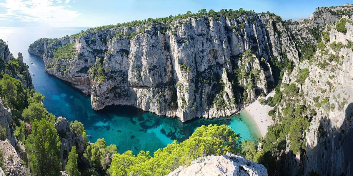
Calanques National Park
Parc national des Calanques
Provence-Alpes-Côte d'Azur (Marseille / Cassis / La Ciotat) · France
Photo: kallerna · CC BY-SA 4.0 · Wikimedia Commons
The first European national park that is at once terrestrial, marine and peri-urban: limestone cliffs and calanques above posidonia meadows at the gates of Marseille.
In the Cosquer Cave, negative handprints remain from 27,000 years ago, and today its entrance is 37 metres underwater. The Calanques massif falls sheer into the sea at the gates of Marseille. It is a national park with three faces at once — terrestrial, marine and peri-urban: 520 km², of which 85 are land and the rest sea, with core zones of about 8,500 hectares on land and 43,500 at sea. The founding decree was signed on 18 April 2012.
What makes it unique
White limestone cliffs plunging into a sea with posidonia meadows and coralligenous walls, at the gates of Marseille.
The place
Nature
The landscape
The massif is mostly Mesozoic limestone, formed between 250 and 65 million years ago in the warm seas of the Jurassic and, above all, the Cretaceous. Fossils of algae, sea urchins and rudists are its witnesses. Rivers did the rest: they carved valleys to the sea, and with fluctuations in sea level the coastline was cut into dozens of calanques. The limestone, heavily fissured, is full of caves and cavities, and springs such as Port-Miou and Bestouan at Cassis.
Underwater, history repeats in its submarine version: coralligenous communities cover the walls and posidonia covers the flats, and among the species with protected or scientifically monitored status are posidonia, red coral, date mussel and fan mussel. On land more than twenty-six natural habitats have been catalogued, along with about nine hundred plant species and eighty-three protected species.
Wildlife and seasons
In coastal waters turtles and dolphins are sometimes seen, and among threatened fish are the grouper, the brown meagre, the dentex and the long-snouted seahorse. The monk seal is a lost story: the last one in the Calanques was shot around 1945.
In the air and on land, Bonelli's eagle, the Scopoli's shearwater and the Yelkouan shearwater frequent the park. There are twelve reptile species and four amphibian species, and the horseshoe bat shelters in the karstic cavities of the massif. On the island of Riou, peregrine falcons were captured in the Middle Ages to be sold for falconry.
In summer, fire risk governs the visit: with red alert the massifs are closed.
Species
With a page in the atlas
Being mentioned in a source doesn't guarantee sightings: check with the people who manage the area.
Memory and protection
History and conservation
Human presence here is ancient. The paintings and engravings of the Cosquer Cave date from between 27,000 and 19,000 years before Christ and depict terrestrial and marine animals — bison, ibex, horses, seals and penguins; entry today is forbidden following a fatal diving accident. On the island of Riou there are traces of occupation from about 8,000 years ago, when it was still a peninsula joined to the Marseilleveyre massif. Later came shepherds, with flocks on the land and on the island of Riou, the «island of the Goats», and they burned the scrub to gain pasture; around 1300 watchtowers were built at Marseilleveyre, Maïre and Riou to warn the city of approaching pirates.
Protection has deep roots. At the beginning of the twentieth century the Excursionnistes marseillais (1897) and the Club alpin promoted hiking and built refuges and trails, and in 1923 a defence committee was founded to prevent the industrialisation of En-Vau.
Before you set off
Visiting
How to visit
The Calanques are explored on foot. The GR 51-98 crosses the massif from west to east, and the calanques of Callelongue, Sormiou and Morgiou are inhabited and reachable by road; Cassis is another important starting point, from Port-Miou. The paths are steep, with risky sections for inexperienced walkers and dangerous in the mistral.
There are no water points in the massif and barely any shade: the park asks for at least 1.5 litres per person for half a day. There are no bins either, so you take your rubbish home and sort it there. Respect the vegetation regeneration zones, bounded by stakes and wire, and do not move the stones, which shelter insects and lizards.
Before you go
Each year, from 1 June to 30 September, access to the forested massifs of the Bouches-du-Rhône is regulated by prefectoral decree because of fire risk, and with red alert it is prohibited. With that alert you can still follow the coast by boat, but landing is strictly forbidden. Check conditions before setting out.
Sugiton is the extreme case. Peaks of 2,500 visitors per day were recorded, and trampling sends soil sliding towards the beach and exposes the roots of old pines. To slow erosion, the park requires a free online reservation to enter the Sugiton and Pierres Tombées calanques during peak season. It opens three days in advance, closes at 18 h the day before and is cancelled if the massifs are closed due to fire risk.
Check access, rules and visiting conditions in the official information from the managing body before you set off.
Location
Where it is and how far it reaches
Boundary of Calanques · © EEA, CDDA (CC-BY) The coordinate is estimated; it isn't a verified access point.
Transparency
Sources
The research data with its sources, and the official links for this place, are in the Spanish version of this page. See the Spanish version
Around it
The atlas has no close neighbours to the Calanques, but it does share species and habitats — such as the Yelkouan shearwater, the Scopoli's shearwater and posidonia — with the Tuscan Archipelago National Park, Lastovo Archipelago Nature Park and La Mola (Formentera).
If you like this place, elsewhere in Europe
Distant places with uncommon wildlife and habitats in common. The most widespread species don't count. Sharing species doesn't imply a corridor or guaranteed presence.
- Lastovo Archipelago Nature Park
Dubrovnik-Neretva (Lastovo Island)
In common: Yelkouan shearwater · Scopoli's shearwater · Posidonia oceanica — wild coast, marine, mediterranean forest
One of Croatia's most remote inhabited islands and dozens of islets, with pristine night skies and largely undisturbed seabed ecosystems.
JFMAMJJASONDMay – June · September – October · Crowding very low
- Karst Plateau and Cliffs of La Mola
Balearic Islands (Formentera / El Pilar de la Mola)
In common: Scopoli's shearwater · Posidonia oceanica — wild coast, marine, karst and caves
Independent limestone plateau elevated 200 m above the sea with precipitous desert-like cliffs at the eastern tip of Formentera.
JFMAMJJASONDApril – June · September – October · Crowding low
Entry #1017 of the original atlas.