Hautes Fagnes–Eifel Nature Park
Parc Naturel Hautes Fagnes-Eifel
Province of Liège / German-speaking Community (Eupen / Malmedy / Sankt Vith) · Belgium / Germany
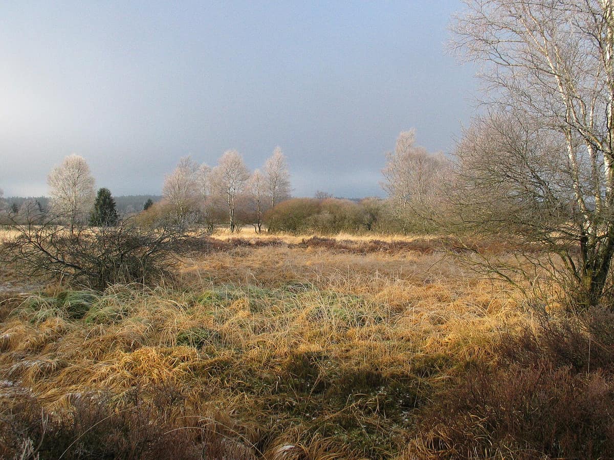
Photo: Aline · CC BY-SA 3.0 · Wikimedia Commons
The largest raised bog plateau in Western Europe (600 km²), home to the highest point in Belgium.
You climb through the "Venndach", between firs, and suddenly the forest ends. Before you opens a plateau of unfarmed peat bogs and heathland, with bog grass rippling as far as the eye can see. This is the Hautes Fagnes plateau, the largest peat bog massif in Belgium and the heart of the Hautes Fagnes–Eifel Nature Park, which extends over 72,000 hectares and twelve municipalities. Here, at 694 m at the Signal de Botrange, lies the summit of Belgium.
What makes it unique
A peat bog dating back 7,500 years where the black grouse holds on at the western edge of its range, and Belgium's highest point.
The place
Nature
The landscape
The story begins with ice. At the end of the last glaciation, around 7,500 years ago, plants — especially sphagnum mosses — grew and decomposed incompletely in waterlogged soil, gradually building up thick layers of peat. Of the original peat bogs, covering around 1,000 hectares, today only about a hundred remain almost free of human influence. The landscape also features palsas, nearly circular hollows from the glacial era, several metres deep, where sphagnum established early and now hosts small, very ancient bogs.
Water rules everything. The peat absorbs rain like a sponge, and what it cannot hold feeds the reservoirs of the neighbouring Eifel through streams.
The colour changes with the season. In autumn the bog grass turns rusty orange; in winter and spring, a pale yellow. Twisted birches, eared willows, the odd fir and rowans give strange silhouettes. And beneath them, the dry heathland holds bilberry, bog bilberry and heather; on the raised bog grow bog rosemary, crowberry, round-leaved sundew and sphagnum mosses.
Wildlife and seasons
The black grouse is the symbol. It is a relic of the last glaciation, and the Hautes Fagnes are one of its last refuges at the western edge of its range. The last count found about twenty males at their lekking sites. Its decline is due mainly to climate: mild winters and cool springs with too much moisture in the first weeks of the chicks' lives. Foxes also reduce breeding success.
Around it, life is discreet. Red deer and roe deer graze on the heathland; the polecat is the carnivore that most frequently visits the bog, followed by the stoat. Among the nesting birds is the meadow pipit, hidden in grass tussocks; among raptors the common buzzard, the hen harrier, the short-eared owl and the boreal owl, which has nested in old fir stands since 1963. There are three newt species, including the Alpine newt, and only three reptile species: the viviparous lizard, the slow worm and the grass snake. And the caterpillar of the butterfly Boloria aquilonaris feeds almost exclusively on bog bilberry.
The C zones of the park close almost every year from mid-March to the end of June for the black grouse breeding season, even for guided groups.
Species
With a page in the atlas
Being mentioned in a source doesn't guarantee sightings: check with the people who manage the area.
Memory and protection
History and conservation
Human traces go back centuries. The stone road on a wooden base crossing the bog was believed to be Roman, but was actually built in the seventh or eighth century; locals call it the "Pavée de Charlemagne". Traditional uses — grazing, mowing, peat extraction — transformed most of the broadleaf forest into the current heathland. At Baraque Michel, a family rang a bell every evening to guide travellers lost in the fog.
Protection came later. In 1966 the Council of Europe granted the area its Nature Protection Diploma, and in 1971 the park boundaries were drawn following natural rather than administrative features. The remaining bogs suffer from air pollution and old drainage ditches; since 1994 there have been trial plots to reactivate dying bogs. Tracks crossing intact bogs were closed.
Before you set off
Visiting
How to visit
Start at the Botrange centre, the park's administrative headquarters. It has exhibitions, films and leaflets, regular guided visits to bogs, heathlands and forests at weekends and on public holidays, and rubber boot loans for those wanting a short walk. Wheelchair-accessible path visits are available on request. At Haus Ternell, between Eupen and Mützenich, there is an annual programme and a small forest museum.
There are three interpretive trails: the Poleûr trail, with a companion booklet sold at the centre; the Neûr Lowé trail; and the Ternell trail, with geological content. For longer walks, the GR 573 and GR 56 long-distance routes. With AVES Ostkantone there are guided birdwatching visits. In winter, cross-country skiing is only allowed on prepared tracks, located at the edges of or outside the reserves; cycling is restricted to a signposted network in the forests surrounding the reserves.
Bring rubber boots and an umbrella: it rains and snows a lot here.
Before you go
Access is zoned. B zones are open during the day; entering C zones requires a recognised guide; D zones are closed to the public. In dry weather all bogs except the small Poleûr are closed, and red flags are raised at the entrances: do not enter. It is forbidden to light fires, camp or bivouac outside designated areas, and nothing may be collected in the reserves. On the boardwalks and narrow paths, cycling and horse-riding are not permitted.
Check access, rules and visiting conditions in the official information from the managing body before you set off.
Location
Where it is and how far it reaches
Boundary of Hautes Fagnes · IUCN IV · © EEA, CDDA (CC-BY) The coordinate is estimated; it isn't a verified access point.
Transparency
Sources
The research data with its sources, and the official links for this place, are in the Spanish version of this page. See the Spanish version
Around it
The Naturpark Our – Ourtal lies about thirty kilometres away. Further afield, the Parco Naturale delle Alpi Marittime shares with the Hautes Fagnes the black grouse and mature forest habitats.
If you like this place, elsewhere in Europe
Distant places with uncommon wildlife and habitats in common. The most widespread species don't count. Sharing species doesn't imply a corridor or guaranteed presence.
- Maritime Alps Natural Park
Piedmont (Cuneo / Valdieri / Entracque)
In common: Black grouse · Grey wolf — old-growth forest
United with France's Mercantour National Park, it forms a massive cross-border Alpine-Mediterranean wilderness crowned by Mount Argentera (3.297 m).
JFMAMJJASONDJune – October · Crowding low
Entry #375 of the original atlas.