Piatra Craiului National Park
Parcul Național Piatra Craiului
Brașov and Argeș Counties (Zărnești) · Romania
Photo: xulescu_g · CC BY-SA 2.0 · Wikimedia Commons
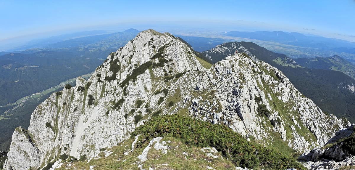
The "Royal Ridge", the sharpest and most spectacular alpine limestone blade in the Carpathians (25 km of unbroken crest).
A limestone blade 25 km long planted in the middle of the Carpathians. Piatra Craiului is not a mountain of rounded peaks and gentle slopes: it is a continuous crest, the highest and longest limestone ridge in Romania, rising between Argeș and Brașov counties with its apex at Piscul Baciului, at 2238 m. The national park protecting it brings together the crest, its screes, its gorges, and the forests on its lower slopes, with Zărnești serving as the main gateway.
What makes it unique
A single limestone wall concentrates 1199 plant species and subspecies, a flower that grows nowhere else, and a ridge that has drawn mountaineers for over a century.
The place
Nature
The landscape
Start at the bottom, where the story of everything lies. In the northeast of the park, the Zărnești Gorges (Prăpăstiile Zărneștilor) began forming hundreds of millions of years ago, with soluble limestone accelerating their carving. It occurred in four stages: first a surface river; then water sank underground to carve a cave; later the roof collapsed, turning the cavern into a narrow defile of vertical walls; finally, the stream went subterranean once again. Today it is a dry canyon 3,9 km long, bearing witness to Jurassic geological forces. The Dâmbovicioara gorges tell a similar story, and their cave, hollowed in Jurassic limestones, contains a 555 m gallery.
Higher up, scree rules. Scree fields span between 1300 and 2200 m altitude and are largely active: they cascade down valleys on both flanks, forming genuine rivers of stone. On the western slope at 1720 m, Cerdacul Stanciului represents the massif's grandest karst arch, the remnant of an ancient cave whose collapsed ceiling left a central limestone block standing.
The park's lowest point, at 735 m, sits at the confluence of the Dâmbovicioara and Dâmbovița rivers. Between the valley floor and the crest, beech forests give way to relict Scots pine stands on limestone and scrub of mountain pine and rhododendron.
Wildlife and seasons
The flower giving fame to the massif is the Piatra Craiului carnation, garofița Piatrei Craiului (Dianthus callizonus), a strict endemic: it grows on the cliffs and crags of this range and nowhere else. It is also the floral emblem of the massif. Accompanying it are edelweiss, lady's slipper (Cypripedium calceolus), yellow alpine poppy, and other protected plants. The botanical inventory is enormous: 1199 species and subspecies, with 181 appearing on Romania's red list as endemic, rare, or vulnerable.
Among mammals, park authorities highlight large carnivores: the brown bear, grey wolf, and Eurasian lynx. There are 21 bat species, 112 bird species (the park is recognized as a prime birdwatching ground), and more than 220 chamois on the rocky precipices. Forest mammals also include the red deer, roe deer, and European pine marten.
The finest season to visit runs from June to October. The administration organizes guided excursions to watch wildlife and interpret animal tracks in the wild.
Species
With a page in the atlas
Being mentioned in a source doesn't guarantee sightings: check with the people who manage the area.
Memory and protection
History and conservation
Chamois hunters and shepherds were the first to ascend the ridge, becoming the earliest local guides. The highest peak's name, Piscul Baciului, derives from traditional pastoral life. In mid-September 1872, a group of Transylvanian Saxons from Brașov scaled the massif and decided on the summit ridge to establish the Transylvanian Alpine Society. In August 1886, Friedrich Deubel climbed down the western face.
The earliest mountain shelters were built by chamois hunters between the two world wars. In Peștera Liliecilor in the village of Peștera, archaeologists uncovered Paleolithic human traces, and the Dâmbovicioara cave sheltered local villagers from invading armies during the eighteenth century.
The massif gained protection as a natural reserve on 28 March 1938. Today it is a national park and forms part of the Natura 2000 network.
Before you set off
Visiting
How to visit
Begin at the Zărnești visitor centre in the Bârsa Mare valley, one kilometre from the town centre. Its circuit tour interprets flora, fauna, geology, crest and screes, caves, local communities, and hiking trails. Inside, you will find a traditional sheepfold replica, a cave with geological formations, and a 3D terrain model of the park projecting maps of routes, habitats, and bedrock. Wheelchair ramps have an inclination of 6 %, and the interpretive path features tactile markers and braille plaques.
The administration presents 42 walking routes. The gentlest is through the Zărnești Gorges, fully accessible to children and visitors with disabilities. For the ridge, numerous demanding trails ascend from both eastern and western slopes. If you prefer guided visits, accompanied excursions, virgin forest outings, educational walks, and visits to mountain villages like Măgura and Peștera with their traditional sheepfolds are available.
Emergency shelters are scattered along the ridge. The highest sits at Șaua Grindului, at 2026 m. Visitors are requested to use them strictly in emergencies.
Before you go
Choose an itinerary matched to your fitness, consult the map before setting out, and if in doubt, seek advice from park authorities or mountain rescue. Stay on official marked trails, do not bring cars, motorbikes, or quad bikes into areas where motor access is barred, and camp only in permitted sites.
Bears are present. To avoid attracting them, never store food inside your tent: hang it from tree branches at least 2 metres off the ground, well away from the trunk. Stay alert and watch for signs of bear activity (overturned stones, scratched logs, torn anthills).
Check access, rules and visiting conditions in the official information from the managing body before you set off.
Location
Where it is and how far it reaches
Boundary of Parcul Național Piatra Craiului · IUCN II · © EEA, CDDA (CC-BY) The coordinate is estimated; it isn't a verified access point.
Transparency
Sources
The research data with its sources, and the official links for this place, are in the Spanish version of this page. See the Spanish version
Around it
Around 5 km away lies Bucegi National Park - Western Slopes, and at 0 km, bordering the massif directly, are the Leaota Mountains.
What else to explore nearby
Approximate straight-line distance between the edges of each area. It doesn't indicate access, routes or driving times.
- Bucegi National Park - Western Slopes
Dâmbovița, Argeș, and Prahova Counties
About 5 km away
Dramatic conglomerate cliffs rising toward the plateau of the Babele and Sphinx wind-sculpted rock formations.
JFMAMJJASONDJune – October · Crowding low
If you like this place, elsewhere in Europe
Distant places with uncommon wildlife and habitats in common. The most widespread species don't count. Sharing species doesn't imply a corridor or guaranteed presence.
- Retezat National Park
Hunedoara County (Hațeg)
In common: Leontopodium alpinum · Cypripedium calceolus · European pine marten — high mountain, old-growth forest
The realm of the granitic and glacial Retezat, with over 80 crystal tarns and the Gemenele scientific reserve.
JFMAMJJASONDJune – October · Crowding low
Entry #287 of the original atlas.