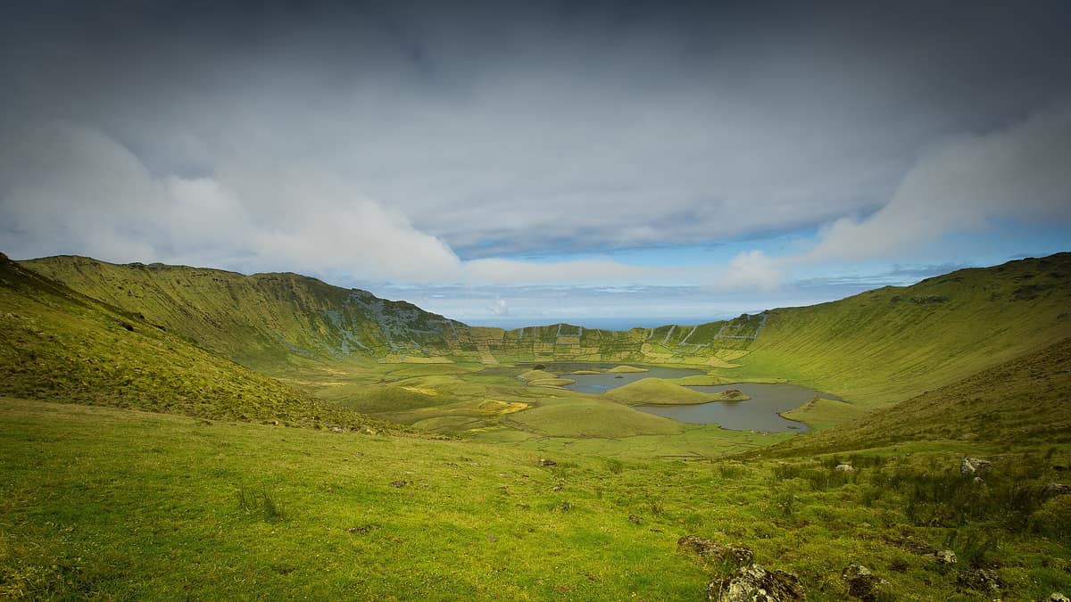
Corvo Island Natural Park (Azores)
Parque Natural da Ilha do Corvo (Açores)
Autonomous Region of the Azores (Corvo Island / Vila do Corvo) · Portugal
Photo: Paulo Valdivieso from Lisboa, Portugal · CC BY-SA 2.0 · Wikimedia Commons
The smallest and most remote island of the Azorean archipelago (17 km²), dominated by the Caldeirão (volcanic collapse caldera holding two interior lagoons).
Corvo is a single volcanic mountain surging out of the North Atlantic. An island of 17.21 square kilometres—the smallest in the Azores archipelago—it represents the emergent peak of an extinct central volcano, Monte Gordo, crowned by a summit collapse caldera with a perimeter of 3.7 kilometres and a depth of 300 metres: the Caldeirão. Across its floor lie lagoons, peat bogs, and miniature volcanic islets, framed by dizzying maritime cliffs that plunge precipitously into ocean swells.
What makes it unique
It is the smallest island of the Azores and a volcanic crater with lagoons where storm-blown vagrant birds make landfall that are never otherwise seen in continental Europe.
The place
Nature
The landscape
Corvo belongs to the Western Group of the archipelago, lying just north of Flores with which it shares a common submarine bank. The volcanic edifice began breaching the surface roughly 730 thousand years ago, with the central caldera collapsing around 430 thousand years ago. Inside the caldera floor rise secondary scoria cones and spatter mounds between 20 and 30 metres high that cradled the lagoons and peat bogs, punctuated by diminutive islets: two elongated and five rounded domes.
The highest topographic point is Estreitinho, perched on the southern rim of the Caldeirão at 720 metres. To the west plunges a sheer vertical sea cliff of some 700 metres, among the highest marine cliffs in the entire Atlantic Basin. Here relentless westerly and north-easterly gales and wave battering drive coastal retreat, so that the sea cliffs have already breached the western rim of the caldera.
Only in the extreme south, upon a low basaltic lava platform (fajã), rests Vila do Corvo, the sole human settlement on the island. Agriculture is confined to the immediate surrounds of the village and a sheltered pocket along the eastern shore, at Quintas and Fojo; the richest pastoral uplands stretch across the north, in the Terras Altas.
The climate is oceanic, humid yet temperate and relentlessly windy, with thick summit mist nearly permanent across the heights. June heralds the dense 'nevoeiros de São João', when sea fogs are most pervasive.
Wildlife and seasons
Corvo is internationally renowned as an exceptional destination for birdwatching. It intercepts transoceanic vagrants drifting off migratory flyways across North America and Europe, deflected off course by Atlantic cyclones, drawing dozens of birders throughout the autumn who scour the trails and the shores of Lagoa do Caldeirão. Several species recorded here have never been documented anywhere on the European mainland.
For seabirds, the island and adjacent Flores combine their surrounding waters to constitute an Important Bird Area (IBA) designated by BirdLife International covering 210,400 hectares, providing vital feeding and nesting grounds for Cory's shearwater, Barolo shearwater, Manx shearwater, roseate tern, and common tern.
On land, the protected area is distinguished by active blanket bogs and native Azorean flora: the park shelters 48 endemic plant species, including Azorina vidalii, Myosotis azorica, and Veronica dabneyi.
Species
With a page in the atlas
Being mentioned in a source doesn't guarantee sightings: check with the people who manage the area.
Memory and protection
History and conservation
Permanent human settlement began around 1580, when colonists from neighboring Flores took up residence to engage in subsistence farming, pastoralism, and coastal fishing. From the eighteenth century onward, American whaling vessels recruited skilled harpooners across the Western Group, forging stronger maritime ties between Corvo and Boston than with mainland Lisbon. Near the airstrip stand traditional conical windmills of municipal heritage interest: of some 7 that once operated, only 3 remain active today.
In the 1960s, state forestry regimes imposed on community lands dismantled traditional sheep-farming and local wool production. Today livestock rearing remains the bedrock of the primary sector, centred on cattle, pigs, and poultry, with artisanal cheeses and dairy representing the primary exports.
The entire island was designated a UNESCO Biosphere Reserve in September 2007. The Parque Natural do Corvo was established in 2008 to safeguard the territory and promote sustainable development, integrating protected landscapes, a Ramsar wetland, three priority geosites, Natura 2000 tracts, and an IBA marine area.
Before you set off
Visiting
How to visit
The island offers a wild bird interpretation centre, a wildlife rehabilitation facility, two waymarked hiking trails, a voluntary nature reserve, and scenic viewpoints. The two official trails traverse the volcanic landscape along different routes.
The Caldeirão circular trail is of moderate difficulty: 4.8 kilometres taking about two and a half hours. It descends into the collapse caldera of the summit volcano, designated a priority geosite, traversing two Special Protection Areas.
The Cara do Índio route is a linear trail: 10.3 kilometres taking about three hours. It traverses the island from north to south, linking the geosites of the Caldeirão and Vila do Corvo.
Before you go
Corvo is an exceedingly remote island: verify transport schedules and flight connections well in advance, and consult the managing authority regarding trail conditions before venturing across the heights.
Check access, rules and visiting conditions in the official information from the managing body before you set off.
Location
Where it is and how far it reaches
Boundary of Costa e Caldeirao do Corvo · IUCN IV · © EEA, CDDA (CC-BY) The coordinate is estimated; it isn't a verified access point.
Transparency
Sources
The research data with its sources, and the official links for this place, are in the Spanish version of this page. See the Spanish version
Around it
Flores Island lies twenty kilometres to the south, sharing the western submarine ridge. Fajã da Caldeira de Santo Cristo and the Selvagens Islands share with Corvo pelagic shearwaters and windswept Macaronesian coastline.
What else to explore nearby
Approximate straight-line distance between the edges of each area. It doesn't indicate access, routes or driving times.
- Flores Island Natural Park (Azores)
Autonomous Region of the Azores (Flores Island / Santa Cruz / Lajes das Flores)
About 20 km away
The 'Island of Water and Flowers', a UNESCO Biosphere Reserve on the North American tectonic plate with 7 crater lakes (Sete Lagoas) and the Poço da Ribeira do Ferreiro waterfall.
JFMAMJJASONDMay – October · Crowding very low
If you like this place, elsewhere in Europe
Distant places with uncommon wildlife and habitats in common. The most widespread species don't count. Sharing species doesn't imply a corridor or guaranteed presence.
- Selvagens Islands Nature Reserve
Autonomous Region of Madeira (Selvagem Grande / Selvagem Pequena)
In common: Audubon's shearwater · Calonectris borealis · Sterna hirundo — wild coast, marine
Portugal's southernmost territory and one of Europe's oldest strict marine reserves (1971), harbouring the world's densest colony of Cory's shearwater (Calonectris diomedea).
JFMAMJJASONDMay – September · Crowding none
Entry #526 of the original atlas.