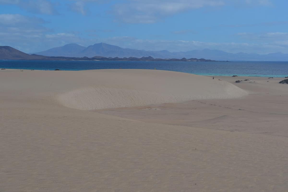
Dunas de Corralejo Natural Park
Parque Natural de Corralejo
Canary Islands (Fuerteventura / La Oliva / Corralejo) · Spain
Photo: Iván Hernández Cazorla · CC BY-SA 4.0 · Wikimedia Commons
The largest field of organic fossil sand dunes in the Canary Islands (2,600 ha), contrasting turquoise waters with volcanic desert landscapes.
Imagine a white sand desert meeting a turquoise sea without transition. That is the initial impression of Corralejo Natural Park in northeastern Fuerteventura: a coastal strip measuring 2.5 by 10.5 kilometres sheltering the largest dune field in the Canary Islands. Spanning more than 2600 hectares within the municipality of La Oliva, it was classified as a natural park in 1994. Yet the sands tell only half the tale, as the park comprises two remarkably contrasting sectors.
What makes it unique
A single excursion connects an expansive white dune system made of pulverised marine shells with an arid volcanic south of dramatic ochre and crimson hues.
The place
Nature
The landscape
To the north, bordering the resort of Corralejo, unfolds the grandest sand field in the Canarian archipelago: a sweeping expanse of white sands washed by translucent turquoise shallows. Its genesis is entirely organic. The dunes arise from the fragmentation and fine pulverisation of mollusc shells and marine calcareous organisms, creating an active shifting dune field that partly blankets fossilised dunes likely dating to the Upper Pleistocene. In several shoreline zones, fossil beaches laden with ancient marine shells outcrop above the tide line.
To the south the landscape transforms completely. The southern sector is ruggedly volcanic, exhibiting ochres, terracottas, and deep reds across jagged basalt slopes. Between these opposing poles, the park blends coastal halophytic flats, active and stabilised dunes, red clay basins, and volcanic malpaís.
Vegetation adapts precisely to each sub-habitat. Along the coastline grow sea-grape, zygophyllum, birdsfoot trefoil, sea bindweed, and sea-rocket; in the rough basalt malpaís thrive balsam spurge, euphorbia, and caralluma.
Wildlife and seasons
Representative birds of northern Fuerteventura include the Canary Islands stonechat, strictly endemic to the island, alongside the houbara bustard, stone-curlew, black-bellied sandgrouse, trumpeter finch, Barbary falcon, and the Egyptian vulture (guirre), a critically endangered island subspecies. The park's Important Bird Area shelters houbara bustard, stone-curlew, cream-coloured courser, and Berthelot's pipit. On land live Canarian shrews, Atlantic lizards, and East Canarian geckos. In all, Fuerteventura hosts 2,672 terrestrial species, of which 541 are Canarian endemics and 128 exist nowhere else on Earth.
The adjoining sea adds marine richness. Waters off La Oliva harbor bottlenose dolphins, striped dolphins, Risso's dolphins, Cuvier's beaked whales, sperm whales, and Bryde's whales. The municipality identifies ten choice spots for wildlife observation, including Tostón Lighthouse, Charco de Bristol, Bajíos de Corralejo, and Majanicho.
Species
With a page in the atlas
Being mentioned in a source doesn't guarantee sightings: check with the people who manage the area.
Memory and protection
History and conservation
The mobile dunes are designated as a restricted-use conservation zone under the park master plan. Moreover, more than half of La Oliva municipality is environmentally protected, and the entire island, shoreline included, is a UNESCO Biosphere Reserve. The Cabildo warns strictly against the gathering of stones, shells, and rhodoliths; left-behind food scraps sustain feral cats and rodents, which pose severe threats to ground-nesting birds like the guirre and houbara.
Before you set off
Visiting
How to visit
The FV-1 coastal highway skirts the park, but vehicles must pull into designated roadside laybys with access on foot. For the volcanic south, wear sturdy hiking footwear: a climb of roughly 300 metres scales the Montaña Roja volcano, rewarding hikers with views of Lanzarote and La Graciosa across the Bocaina strait. The island council (Cabildo) has organized a ninety-minute botanical trail across the sands, and La Oliva municipality publishes walking guides detailing pathways crossing the dunes. Informational leaflets on park geology and ecology are available from local offices.
Take water and respect the fragile sands during your visit.
Before you go
Walk only along designated tracks and obey boundary signs: venturing off marked pathways causes severe erosion in fragile dunes. Do not collect stones or build stone cairns, and leave no food scraps behind.
Check access, rules and visiting conditions in the official information from the managing body before you set off.
Location
Where it is and how far it reaches
Boundary of Corralejo · IUCN Ib · © EEA, CDDA (CC-BY) The coordinate is estimated; it isn't a verified access point.
Transparency
Sources
The research data with its sources, and the official links for this place, are in the Spanish version of this page. See the Spanish version
Around it
Parque Natural Marítimo-Terrestre del Cabo de Gata-Níjar shares the houbara bustard with Corralejo, uniting coastal, steppe, and marine environments.
If you like this place, elsewhere in Europe
Distant places with uncommon wildlife and habitats in common. The most widespread species don't count. Sharing species doesn't imply a corridor or guaranteed presence.
- Cabo de Gata-Níjar Maritime-Terrestrial Natural Park
Andalusia (Almería / Níjar / Carboneras / San José), [36.75, -2.18]
In common: Houbara bustard — wild coast, steppe and grassland, marine
The largest protected marine-terrestrial area of volcanic origin in Mediterranean Europe, featuring lava cliffs, fossil dunes and Posidonia meadows.
JFMAMJJASONDApril – June · September – November · Crowding moderate
Entry #649 of the original atlas.