Vjosa Wild River National Park
Parku Kombëtar Lumi i Egër Vjosa
Southern Albania (Përmet / Tepelenë / Memaliaj) · Albania
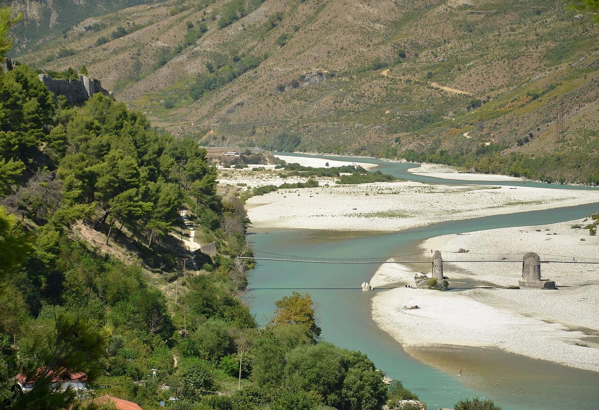
Photo: Pudelek · CC BY-SA 4.0 · Wikimedia Commons
Europe's first wild river national park: the Vjosa flows entirely undammed from Greece to the Adriatic Sea.
The Vjosa rises in the mountains of Greece and flows for 270 km, 190 of them across Albania, without encountering a single dam or reservoir. That free flow led to its declaration as Europe's first wild river national park on 15 March 2023, following years of dedicated international campaigns. The river shapes its course according to hydrology alone: carving narrow gorges, charging over rapids, skirting gravel bars and braided channels in its middle reaches, and forming a near-natural delta on the Adriatic coast. Exploring it means following a living, dynamic river rather than an artificial monument.
What makes it unique
A European river that still runs free from mountain source to sea, protected as a national park so it remains that way.
The place
Nature
The landscape
The setting begins with geology. The Vjosa carves through the southern sector of the Albanides, crossing folded anticlines and synclines influenced by active tectonic faults. Between Dragot and Poçem, along its middle reach, it flows predominantly across flysch formations within the Ionian tectonic zone. Beneath the surface, the karstification of regional carbonates feeds 47 permanent freshwater springs throughout the valley.
The river carves a dynamic mosaic: steep limestone canyons upstream, broad gravel plains with braided channels in the central valley, and an expansive delta at its mouth. Periodic major floods, occurring at intervals of one to five years, play a crucial role across the lower floodplains, continuously reshaping riparian margins and mid-channel islands. The middle reach alone encompasses at least eight habitat types of European conservation priority.
Upon this shifting bed of gravel grows hardy vegetation adapted to violent currents. Willows, poplars, and tamarisks act as pioneer colonizers along shores and bars, while the wider alluvial floodplains support oriental planes, elms, and alders resilient to sharp water fluctuations. Beyond the riparian zone spread deciduous scrub, reedbeds, wet meadows, and diverse herbaceous plant communities.
Wildlife and seasons
The valley constitutes a major biodiversity hotspot in Albania, harboring more than eleven hundred recorded species, including the Eurasian otter, the Egyptian vulture, and the critically endangered Balkan lynx. The basin records 257 bird species. The river also maintains robust populations of the critically endangered European eel.
Bird monitoring peaks in June. Comprehensive surveys in June 2023 located enormous breeding colonies of sand martins, estimating between 12,940 and 14,672 pairs nesting along the Vjosa and its tributaries, with one of the largest concentrations near Selenica. Extensive gravel bars between Kashishte and Memaliaj support nesting Eurasian stone-curlews, which require broad, undisturbed expanses of shingle. Furthermore, dynamic gravel spits beside swift currents offer optimal nesting territory for little ringed plovers, with core populations recorded between Mifol and the Drino confluence.
The Mediterranean climate brings hot, dry summers and mild, rainy winters. June, July, and August are the warmest months, while December to February register the lowest temperatures.
Species
With a page in the atlas
Being mentioned in a source doesn't guarantee sightings: check with the people who manage the area.
Memory and protection
History and conservation
IUCN Category II designation aims to safeguard the entire catchment from hydroelectric dams, commercial gravel extraction, and industrial encroachment. The establishment also seeks to address water and soil contamination, municipal waste management, and catchment deforestation.
Key conservation pressures include unregulated gravel quarrying, disturbance of nesting colonies by human activities, and feral animals, particularly between Mifol and Dragot and along the Shushica. Upstream in Greece, the headwaters—locally named the Aoos—are protected within the Vikos-Aoos National Park, though that stretch lies beyond the Albanian park boundary.
Rewilding projects
Before you set off
Visiting
How to visit
Because the river flows largely alongside regional highways, exploring by vehicle is the primary travel method. The corridor passes Përmet, Këlcyrë, and Tepelenë—where the Drino joins—and continues past Memaliaj, Selenicë, and Novoselë. The national park protects the Vjosa and its free-flowing tributaries, including the Drino with Kardhiq, Bënça, and Shushica, safeguarding over 400 km of river courses and 12,727 hectares.
Beyond formal trails, the valley offers notable historical monuments. Along the Shushica near Brataj, a historic stone bridge still serves pedestrians. The Bënça aqueduct formed part of the regional waterworks built under Ali Pasha in the nineteenth century. Near the exit of the Këlcyrë gorge stands the striking steel bridge of Dragot, constructed in 1936.
The sustainable tourism concept envisions a primary visitor centre in Tepelenë and complementary information posts in Vlorë and Përmet featuring interactive displays and educational exhibits; these facilities remain planned developments. A proposed research centre in Tepelenë is also designed to welcome visitors.
Before you go
Plan your trip with care: the national park management plan is an evolving framework and formal park visitor centres are still being developed. Key visitor guidelines are clear: avoid disturbing wildlife or interfering with breeding birds, and keep noise to a minimum. Steer clear of shallow spawning shallows and sensitive gravel bars used for nesting and roosting. Always carry out any litter you generate.
Check access, rules and visiting conditions in the official information from the managing body before you set off.
Location
Where it is and how far it reaches
Boundary of Lumi Vjosa · IUCN II · © EEA, CDDA (CC-BY) The coordinate is estimated; it isn't a verified access point.
Transparency
Sources
The research data with its sources, and the official links for this place, are in the Spanish version of this page. See the Spanish version
Around it
The Osum River Grand Canyon lies about 20 km away. Further afield, the Drava River and Floodplain shares sand martin, little ringed plover, and black stork along a dynamic river corridor. Els Ports Natural Park converges on Hermann's tortoise, Egyptian vulture, and otter; S'Albufera de Mallorca Natural Park shares European eel and European pond turtle; and Strandzha Natural Park shares Hermann's tortoise, black stork, otter, and protected river habitats.
If you like this place, elsewhere in Europe
Distant places with uncommon wildlife and habitats in common. The most widespread species don't count. Sharing species doesn't imply a corridor or guaranteed presence.
- Els Ports Natural Park
Catalonia / Aragon / Valencian Community (Tarragona / Teruel / Castellón / Roquetes / Tortosa)
In common: Hermann's tortoise · Egyptian vulture · Eurasian otter — gorge and canyon
A rugged karst massif between Catalonia, Aragon, and the Valencian Community featuring limestone cliffs, southern beech groves, and the Iberian ibex.
JFMAMJJASONDApril – June · September – November · Crowding low
- Körös-Maros National Park
Southeastern Great Hungarian Plain (Békés / Csongrád-Csanád)
In common: Emys orbicularis · Black stork · Eurasian otter — river corridor
Mosaic of saline puszta grasslands, loess steppes, and riparian gallery forests harbouring Central Europe's premier great bustard stronghold.
JFMAMJJASONDApril – June · Crowding very low
Entry #1007 of the original atlas.