Ahja River Valley Landscape Reserve
Ahja jõe org maastikukaitseala
Põlvamaa (Põlva / Taevaskoja) · Estonia
Photo: Hei1972 · CC BY-SA 4.0 · Wikimedia Commons
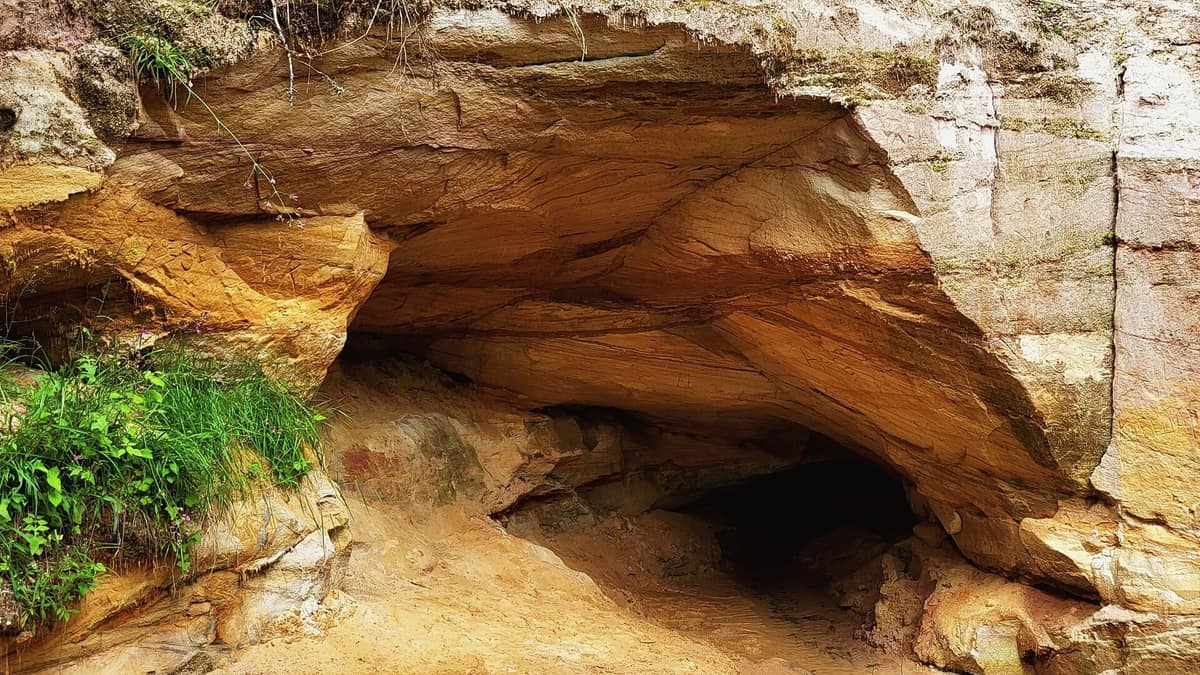
Ancient river canyon gouged into Devonian red sandstone featuring sacred cliff walls like Suur Taevaskoda (The Great Heavenly Hall).
Estonians gave the name "heavenly halls" to sheer walls of ochre-red sandstone. These are the taevaskoda, dramatic outcrops lining the gorge of the Ahja River, evocative of subterranean chambers bounded by sandstone walls under an open sky vault. The Ahja River rises in Lake Erastvere, stretching 103.8 km before draining into the Emajõgi; across its middle reaches, this landscape reserve safeguards 18 km of an ancient meltwater valley carved through Devonian sandstone, celebrated among Estonia's most enchanting fluvial landscapes.
What makes it unique
Here the rock face is more than geology: for centuries it served as a sacred sacrificial site where, folk belief warned, scratching the stone would incur the wrath of river spirits.
The place
Nature
The landscape
The valley is ancient, its chronicle etched in sedimentary strata. The Ahja cut deep into Devonian sandstone bedrock, exposing cross-bedded Burtnieki-stage deposits. Its vibrant palette derives from mineral assemblages: quartz, mica, feldspar, ilmenite, garnet, and zircon mingled with reddish, purplish, and grey clays. The last major morphological reshaping unfolded some 15 000 years ago as the retreating Fennoscandian ice sheet dumped moraines and erratics.
The reserve stretches 18 km along the waterway from Koorvere to Valgesoo (Otten) mill, covering 10.4 km². This glacial spillway plunges to depths of 30 m, protecting rivers, meandering streams, flood meadows, artesian springs, sandstone cliffs, and ancient forest tracts. Over forty distinct sandstone outcrops lie within reserve boundaries. What is not rock is dynamic water: flow levels fluctuate sharply, surging during spring thaw as well as after torrential summer cloudbursts.
The sandstone remains intrinsically fragile. In the mid-nineteen-eighties, prolonged summer rains triggered a catastrophic rockfall that sheared a massive section of Suur Taevaskoda into the river. Downstream from the dam, Emaläte, a revered cave-spring, has witnessed recurring roof collapses; in the summer of 2013 its cavern almost completely caved in, yet the subterranean spring promptly broke through afresh. Adjoining Emaläte are Väike Taevaskoda and the mythical Neitsikoobas cave.
Wildlife and seasons
Pristine, oxygenated waters sustain sensitive riverine fauna. Thick-shelled river mussels, spined loach, and European bullhead frequent gravel shallows, while green snaketail dragonflies (Ophiogomphus cecilia) patrol the banks. The corridor supports the Eurasian otter and the common kingfisher, accompanied by rare flora such as Austrian pleurospermum and smooth bedstraw, alongside the endangered forest fungus Sarcosoma globosum.
Seasonal rhythms dictate the river's character. Spring meltwaters cause dramatic swelling, whereas during dry summer spells around Kiidjärve canoe excursions can become nearly impossible due to shallow shoals.
Species
With a page in the atlas
Being mentioned in a source doesn't guarantee sightings: check with the people who manage the area.
Memory and protection
History and conservation
For generations local communities managed the valley with reverent restraint. That delicate stewardship was disrupted by the Tartu-Petseri railway, completed in 1931. Conservation gains commenced in July 1957 with the establishment of protection zones for the Ahja Valley and Tilleoru. Modern management focuses on preserving virgin forests, sandstone outcrops, river terraces, spring complexes, and semi-natural wooded meadows.
The river still bears historic traces of hydro-power: up to 13 watermills once operated, chiefly along the upper and middle course, most of which stand disused today. Saesaare rapid was once peerless among Estonia's lowland cascades until the construction of the local hydroelectric station and its reservoir submerged the natural falls.
Before you set off
Visiting
How to visit
Begin at Saesaare. The designated Taevaskoda nature trail departs from the parking area, tracking the Ahja downstream toward Suur Taevaskoda and looping back along the opposite bluff over 3 km. Saesaare also serves as the trailhead for the longer Taevaskoja–Kiidjärve–Taevaskoja circuit covering some 12 km. The Roiupalu study trail forms a 3.2 km loop between the Kiidjärve visitor centre, Palanumägi hill, and Hatiku brook, offering guided programmes and interpretive walks for all ages.
Bordering the Saesaare reservoir lie scenic landmarks including Laaritsamägi, Mõsumägi, Kindapäka, Kivipalu, and Mõtstare hill, complemented by the cliff walls of Savioidu and Piirioidu. The setting also attracts fans of the iconic 1969 Estonian historical feature film «Viimne reliikvia», filmed extensively on location here.
Before you go
Remain on demarcated paths at all times. Scratching, defacing, carving names into, or fracturing the fragile sandstone cliffs is strictly prohibited.
Check access, rules and visiting conditions in the official information from the managing body before you set off.
Location
Where it is and how far it reaches
Boundary of Ahja jõe ürgoru maastikukaitseala · © EEA, CDDA (CC-BY) The coordinate is estimated; it isn't a verified access point.
Transparency
Sources
The research data with its sources, and the official links for this place, are in the Spanish version of this page. See the Spanish version
Around it
The Lago Peipus y Delta del Río Emajõgi lies in the downstream catchment of the Ahja. Farther afield, the Río Drava y Llanura de Inundación and Parque Natural Hoces del Alto Ebro y Rudrón share with the Ahja key kingfisher and otter habitats in wooded river corridors.
What else to explore nearby
Approximate straight-line distance between the edges of each area. It doesn't indicate access, routes or driving times.
- Lake Peipus and Emajõgi River Delta
Tartumaa (Kallaste / Varnja / Luunja)
About 18 km away
Europe's fifth-largest lake (3,500 km²) and the vast uninhabited wilderness wetland of the Emajõgi delta.
JFMAMJJASONDMay – October · Crowding very low
If you like this place, elsewhere in Europe
Distant places with uncommon wildlife and habitats in common. The most widespread species don't count. Sharing species doesn't imply a corridor or guaranteed presence.
- Hoces del Alto Ebro y Rudrón Natural Park
Castile and León (Burgos / Sedano / Orbaneja del Castillo / Valdelateja)
In common: Common kingfisher · Eurasian otter — river corridor, old-growth forest
Karst gorges of 200 m carved by the Ebro and Rudrón rivers, featuring the picturesque village of Orbaneja del Castillo and Pozo Azul.
JFMAMJJASONDApril – June · September – November · Crowding low
Entry #425 of the original atlas.