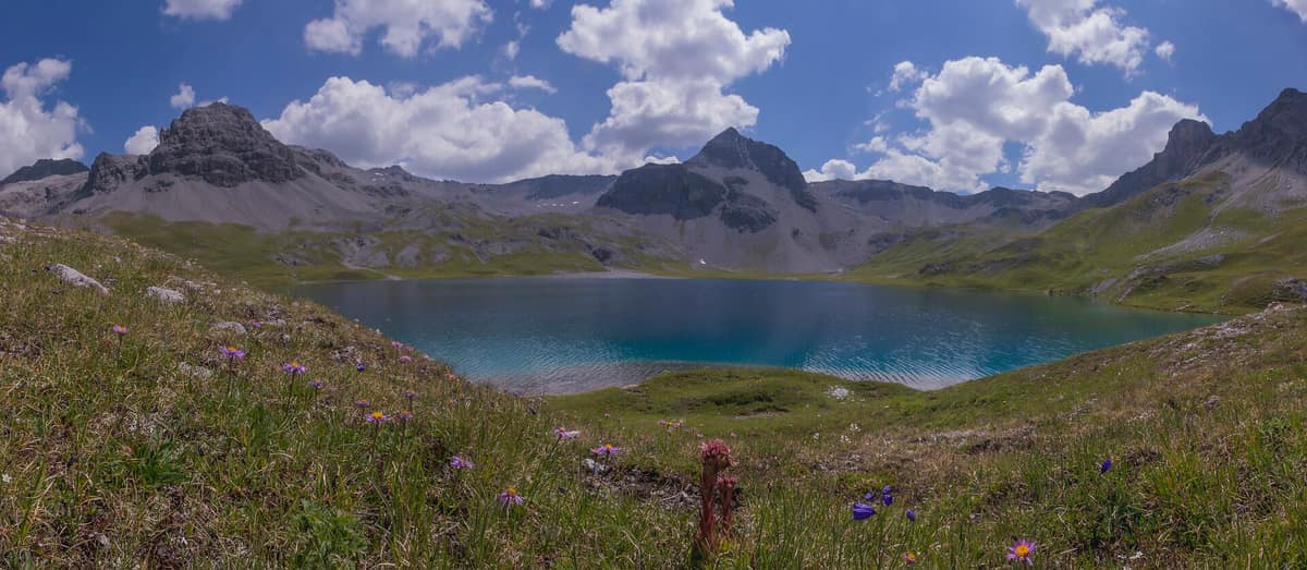
Val Müstair Biosphere Reserve
Biosfera Val Müstair
Graubünden (Santa Maria Val Müstair) · Switzerland
Photo: Ariocarpusandroides · CC BY-SA 4.0 · Wikimedia Commons
Pristine alpine valley bordering the Swiss National Park preserved from heavy transit routes.
There are valleys you cross and valleys you descend. Val Müstair is descended: you begin at the crest of the Fuorn Pass (Ofenpass) and, tier by tier, the descending topography releases you toward Müstair, with Italy's Vinschgau waiting immediately beyond the international frontier. The valley stretches roughly 25 km and its 199 km² regional nature park coincides precisely with the municipal territory at Switzerland's easternmost fringe, where Piz Chavalatsch marks the country's easternmost point. Linked to the adjacent Swiss National Park, it constitutes the nation's inaugural high-alpine UNESCO biosphere reserve.
What makes it unique
An arid inner-Alpine valley where the Italian border marks the frontier of the Romansh language, and where in 2005 a wild brown bear arrived and showed itself to residents.
The place
Nature
The landscape
The valley steps down in three distinct morphological terraces. Highest up lie Tschierv and Fuldera; in the middle tier, Valchava and Santa Maria; at the lowest level, Müstair. Between the pass summit and the border village elevation falls steadily, spanning altitudes from 1225 to 3180 meters across the municipal boundary.
The underlying geology explains the valley floor. Most bedrock consists of fragile crystalline schists that weather easily; lateral torrents dislodge immense volumes of gravel and detritus, depositing them in vast alluvial fans across the main trench. These debris cones mantle virtually the entire valley bottom, creating fertile pockets for local agriculture. Higher up at 2400 m, the glacial cirque lake of Lai da Rims preserves a complete suite of glacial landforms: roche moutonnée surfaces and polished bedrock sills smoothed by former glaciers.
The climate completes the picture. Lying in the inner-Alpine rain shadow with mild Mediterranean influences, it receives less annual precipitation than almost anywhere else in the Alps: only the adjacent Vinschgau, central Valais, and Aosta Valley are drier. This arid regime fosters stark contrasts. In spring, luxuriant meadow flowers burst into bloom alongside ancient stands of European larch and Swiss stone pine.
A hydrological divide splits the terrain at a glance. The Rom carries valley waters eastward toward the Adige and the Adriatic; meanwhile the Aua da Val Mora, in the uninhabited Val Mora basin, drains northward toward the Inn and Danube system bound for the Black Sea.
Wildlife and seasons
For wildlife encounters, begin on high alpine screes and crags. Guided spotting walks equipped with binoculars and spotting scopes target the Alpine ibex and chamois, interpreting their survival adaptations. Further down, dry calcareous grasslands around Müstair and Santa Maria form biodiversity hotspots for two nationally notable butterflies: the hermit (Chazara briseis) and the sloe hairstreak (Satyrium acaciae).
Apex carnivores have returned. According to park authorities, the valley regularly hosts brown bear and grey wolf, alongside monitoring initiatives for the Eurasian lynx. The memory of the bear is fresh: during the summer of 2005 a young brown bear crossed from South Tyrol and roamed in plain sight of tourists, christened Lumpaz. That same year, in the nearby Uina Valley in the Lower Engadine, the first wild bear in Switzerland in nearly a century made headlines.
Summer introduces domestic grazing herds: suckler cattle graze with their calves while livestock guardian dogs watch over sheep flocks across high alpine pastures. Spring celebrates wildflower blooms, while summer belongs to the alpine pastures and their wildlife.
Species
With a page in the atlas
Being mentioned in a source doesn't guarantee sightings: check with the people who manage the area.
Memory and protection
History and conservation
This valley was a contested borderland long before becoming a regional nature park. On 22 May 1499 it witnessed the Battle of Calven, where Graubünden forces decisively repelled Habsburg expansion. Today the Swiss-Italian frontier continues to mirror the linguistic boundary between Romansh and German: it remains the sole southern valley in Graubünden where Romansh is spoken, in the distinctive local dialect called Jauer. In Müstair stands the Carolingian Benedictine Convent of Saint John, a UNESCO World Heritage site.
Formal conservation followed decades later. In 2011 the territory earned the federal label of a Regional Nature Park of National Importance, renewed every ten years under a binding charter; the current charter spans 2021-30. Its boundaries encompass Val Nüglia, part of the Swiss National Park, operating under the Romansh philosophy of Armonia jaura: harmonious balance between society, culture, nature, ecology, and economy.
Before you set off
Visiting
How to visit
The valley is best explored on foot, structured around a network of thematic trails.
The premier high-altitude trek is the Senda Val Müstair: a scenic traverse departing from the Ofenpass, crossing Alp Champatsch, and arriving at Lü, an unspoilt hamlet perched high above the valley, before descending to Müstair. For frontier history, choose between two smugglers' trails: one ascends to Piz Chavalatsch, passing ruined border customs huts; the other links the Umbrail Pass to the Dreisprachenspitze along First World War military mule tracks.
To trace the watercourse, the A la riva dal Rom path covers fourteen kilometers from the headwaters of the Rombach at Süsom-Tschierv down to Müstair. The walk requires about three and a half hours, with 110 meters of ascent and 620 meters of descent, skirting alpine peat bogs, tumbling cascades, and downstream riparian alder groves. An interpretive booklet relates local stream ecology, folklore, and habitats.
Families with children enjoy the Senda da l'uors, a gentle valley-bottom stroll where four hand-carved wooden bears narrate the natural history of bears. Language enthusiasts appreciate the Senda da las linguas, an 8 km audio walk around Valchava featuring eleven interpretive listening stations exploring Romansh place names.
For an ambitious multi-day trek, the four-day Drei Pärke Weg links the Val Müstair Biosphere, Swiss National Park, and Stelvio National Park. Park rangers also lead interpretive summer hikes to alpine pastures to discuss cohabitation with wolves, bears, and lynx, as well as day excursions into the Buffalora Wilderness.
Before you go
You are travelling through working pastures and large-carnivore habitat, where basic rules apply. Stay on marked tracks, respect wildlife resting areas, and pack out all food waste, as scraps habituate wild animals. If a wolf detects your presence, it will typically retreat or flee. In bear country, remain on designated trails and keep dogs on leashes.
The park publishes online maps detailing locations of suckler cow herds and guardian dogs: consult them before departing. Plan your journey carefully, as road access is via the Ofenpass from the Engadine or across the Italian border from Vinschgau.
Check access, rules and visiting conditions in the official information from the managing body before you set off.
Location
Where it is and how far it reaches
Boundary of Biosfera Val Müstair · © OpenStreetMap contributors (ODbL) The coordinate is estimated; it isn't a verified access point.
Transparency
Sources
The research data with its sources, and the official links for this place, are in the Spanish version of this page. See the Spanish version
Around it
Parco Nazionale dello Stelvio adjoins the reserve along the alpine crest, joined by the multi-day Drei Pärke Weg connecting both parks and the Swiss National Park.
What else to explore nearby
Approximate straight-line distance between the edges of each area. It doesn't indicate access, routes or driving times.
- Swiss National Park - Core Zone
Grisons (Zernez / Engadin)
Borders this area
The oldest National Park in the Alps (founded in 1914), a Strict Nature Reserve where all human intervention is forbidden.
JFMAMJJASONDJune – October · Crowding low
- Stelvio National Park
Lombardy / Trentino-Alto Adige (Bormio / Ortler / Sulden / Val Martello)
Borders this area
One of Europe's oldest and most majestic Alpine national parks (Ortles 3,905 m), featuring vast valley glaciers and massive herds of red deer and chamois.
JFMAMJJASONDJune – October · Crowding moderate
Entry #335 of the original atlas.