Malpaís de Güímar Special Nature Reserve
Malpaís de Güímar
Canary Islands (Tenerife / Güímar / Puertito de Güímar) · Spain
Photo: Yerie2017 · CC BY-SA 4.0 · Wikimedia Commons
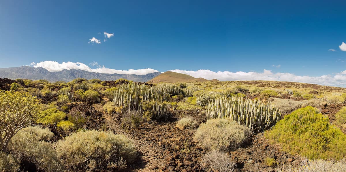
Recent volcanic landscape of pahoehoe and aa lavas dominated by the Montaña Grande cone, colonized by endemic spurge communities.
Less than 5000 years ago, lava erupted from fissures along the base of a cone and surged into the sea. The result is the Malpaís de Güímar: a rugged, stony, chaotic landscape of twisted volcanic formations on the south-eastern coast of Tenerife. Across these basalt fields grow dense clumps of Canary Island spurge (cardón) and sweet spurge (tabaiba), while the terrain slopes from the muted red summit of Montaña Grande down to the ocean edge. Spanning 290,3 hectares, it can easily be explored on foot in a morning.
What makes it unique
One of the best preserved cardón and tabaiba spurge shrublands in the Canary Islands, thriving on lava flows less than 5000 years old.
The place
Nature
The landscape
The story begins at Montaña Grande, the highest point at 276 metres. It formed through successive eruptions accumulating pyroclastic debris, from ash to volcanic bombs, and its volcanic crater spans some 300 metres in diameter and roughly 50 metres in depth. However, the badlands lava did not originate from this vent. Instead, it welled from fissures along the foot of the cone, spreading towards the ocean in jagged aa basalt flows.
The resulting terrain is purely volcanic, with older features like Montaña de la Mar and Las Morras del Corcho emerging amid the lavas having escaped burial. The coastline is indented, dotted with small coves of rounded pebbles and organic sand.
Beneath the surface lies another world. The badlands are honeycombed with volcanic tubes and lava caves, whose presence is revealed by jameos—sunken sections where cavern roofs collapsed. The most remarkable is Cueva Honda (or Cueva de los Burros), measuring over 100 metres in length and up to 5 metres in height; it remains closed to visitors.
The climate completes the setting. Rainfall is scarce, and north-easterly trade winds moderate temperatures, averaging from 17 °C in January to 23 °C in August. Sunshine is abundant, reaching 2500 hours annually, while relative humidity hovers around 70 %.
Across the rock, flora reigns supreme: relatively pristine spurge scrub (cardonal-tabaibal) flourishes with the endemic Canary Island spurge. Near the shore, sea lettuce and sea lavender dominate, whereas coastal sands support gorse and perennial grass tussocks. Across the malpaís, more than 60 lichen species have been documented.
Wildlife and seasons
Keep an eye on the basalt blocks: lizards dart across them basking in the sun. Alongside them dwell Canary wall geckos and skinks. Among the flora, balillo is one of the notable endemics cited in the reserve.
Birds form the dominant vertebrate group, with over a dozen breeding species: Berthelot’s pipit, trumpeter finch, and long-eared owl, alongside southern grey shrike, hoopoe, and common kestrel. Invertebrates represent the most diverse contingent, including numerous endemic species.
Introduced mammals include rabbits, feral cats, rats, and hedgehogs. The gentle climate makes walking pleasant across different seasons of the year.
Species
With a page in the atlas
Being mentioned in a source doesn't guarantee sightings: check with the people who manage the area.
Memory and protection
History and conservation
Early inhabitants made resourceful use of this barren landscape. Aboriginal Guanches stunned fish by poisoning tidal pools with the toxic sap of cardón or bitter tabaiba, a practice known as embarbascado. They also harvested sea salt: two historic salinas remain remarkably well preserved. Winter grazing was practiced before the fifteenth century and continued on a smaller scale in subsequent eras. Latex was harvested from tabaiba plants, and the crater and flanks of the cone were farmed for generations.
The malpaís has been protected since 1987, and in 1989 a board was established for its use and stewardship. The 1994 Canary Islands Natural Protected Areas Law gave it its present designation as the Malpaís de Güímar Special Nature Reserve. Its Master Plan is officially ratified.
Before you set off
Visiting
How to visit
Three trails cross the reserve, with the primary trail serving as the backbone. Starting from Calle Almirante Cervera in Puertito de Güímar, it forms a loop: 6,11 km, around 3 hours, and 169 metres of cumulative elevation gain, rated moderate. It returns to the starting point.
The second trail skirts Montaña Grande along a linear path: 2,7 km, one hour, easy grade. It connects with the main loop to extend the hike. The third route, spanning 1,87 km and roughly 45 minutes, also easy, allows you to begin and finish the primary loop from El Socorro.
Whichever path you take, pause at the viewpoints: they overlook the basalt flows, cardones, and tabaibas that dominate the scenery. The path passes through an area hosting more than sixty lichen species.
To reach the reserve, take the TF-1 motorway and exit towards Polígono Industrial de Arafo; at the first intersection, turn right. The reserve entrance is located roughly 1,6 km ahead.
Before you go
Hike in company along marked trails and respect private properties belonging to local residents. Pack out all trash, including organic waste, and extinguish cigarette butts carefully. Do not collect plants, animals, rocks, or historical artefacts. Minimizing noise will reveal far more wildlife around you.
Check trail conditions beforehand: the management authority posts notices if travel is inadvisable after adverse weather or when path segments undergo repairs.
Check access, rules and visiting conditions in the official information from the managing body before you set off.
Location
Where it is and how far it reaches
Boundary of Malpaís de Güímar · IUCN III · © EEA, CDDA (CC-BY) The coordinate is estimated; it isn't a verified access point.
Transparency
Sources
The research data with its sources, and the official links for this place, are in the Spanish version of this page. See the Spanish version
Around it
Other protected areas on Tenerife include Teide National Park and the Anaga Rural Park.
What else to explore nearby
Approximate straight-line distance between the edges of each area. It doesn't indicate access, routes or driving times.
- Teide National Park
Canary Islands (Tenerife — Las Cañadas)
About 12 km away
A stratovolcano of 3,715 metres rising above a giant caldera: high-altitude volcanic landscape with endemic Canarian flora.
JFMAMJJASONDApril – June · October – November · Crowding high
- Anaga Rural Park
Canary Islands (Tenerife / Santa Cruz de Tenerife / La Laguna / Taganana)
About 21 km away
Volcanic massif anchored 7 to 9 million years ago in north-eastern Tenerife, draped in laurel rainforest, razor-sharp ridges and isolated hamlets.
JFMAMJJASONDAll year · Crowding low
Entry #647 of the original atlas.