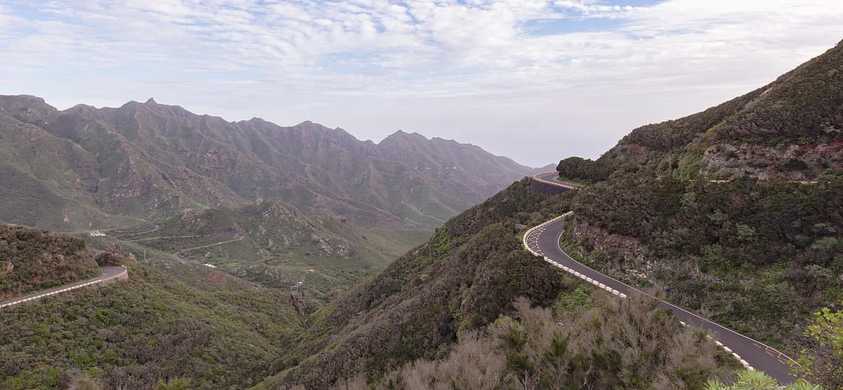
Anaga Rural Park
Parque Rural de Anaga
Canary Islands (Tenerife / Santa Cruz de Tenerife / La Laguna / Taganana) · Spain
Photo: Diego Delso · CC BY-SA 4.0 · Wikimedia Commons
Volcanic massif anchored 7 to 9 million years ago in north-eastern Tenerife, draped in laurel rainforest, razor-sharp ridges and isolated hamlets.
Climb from sunny ocean beaches into sea mists in just a few kilometres. At the north-eastern tip of Tenerife, the Anaga Massif lifts serrated ridgelines over gorges dropping precipitously straight into the Atlantic, safeguarding a forest that has thrived here for 40 million years: the laurisilva, a living relic of the Tertiary. It covers some 14,500 hectares between La Laguna, Santa Cruz de Tenerife and Tegueste, designated a UNESCO Biosphere Reserve since 2015.
What makes it unique
Its ancient cloud forest shelters the laurel pigeon and Bolle's pigeon, two living relicts found nowhere else on earth outside the Canaries.
The place
Nature
The landscape
Anaga is one of the geologically oldest volcanic shields on Tenerife, clearly revealed in its landforms. The roques are eroded volcanic necks; the dykes represent fissures packed with cooled magma; and prominent landmarks include the phonolitic plugs of Chinobre and Anambro, the sea arch of Taganana and the offshore Roques de Anaga. From the central ridge descend deep ravines reaching the sea and framing secluded volcanic beaches.
This dramatic gradient in elevation, climate and soils accounts for high biological diversity within a compact area, representing almost every ecosystem on the island except alpine mountain peaks. On the highest ridges thrives laurel cloud forest. Across mid-altitudes grow Canary juniper, dragon trees and Canary Island date palms. Below on coastal slopes grow euphorbia cardón-tabaiba scrub and halophytic sea-cliff communities. North-east trade winds bring moisture: summit rainforests are often shrouded in mist with brisk temperatures.
Wildlife and seasons
The stars of Anaga's fauna are invertebrates, including nearly a hundred endemic species unique to this massif. Birds include Canarian emblems such as Cory's shearwater, common kestrel, long-eared owl and both laurel forest pigeons, the laurel pigeon and Bolle's pigeon. The cloud forest is vital habitat for these endemic columbids, which is why Anaga is protected as a Special Protection Area for birds.
The coastal waters are equally rich, featuring the common stingray, Canarian hake, parrotfish and an endangered native eel. As for timing, you can visit year-round, though October to May is especially delightful with pleasant temperatures and luxuriant green landscapes.
Species
With a page in the atlas
Being mentioned in a source doesn't guarantee sightings: check with the people who manage the area.
Memory and protection
History and conservation
Anaga was declared a protected nature area in 1987, containing three strict nature reserves: El Pijaral, Ijuana and Roques de Anaga. Its human population numbers roughly 2500 residents scattered across some 26 traditional settlements, with Taganana preserving a pronounced rural character. Long before them, the indigenous Guanches inhabited the ravines and pastured their goats across the ridges.
Before you set off
Visiting
How to visit
Access is via the scenic TF-12 highway, connecting La Laguna with panoramic viewpoints and mountain hamlets. At Cruz del Carmen stands the visitor centre, explaining regional geology, biodiversity and heritage while providing hiking route advice.
Start along the Path of the Senses: short, accessible and deeply representative of the laurel forest, ideal for a first encounter and free to explore. From Cruz del Carmen viewpoint towards Chinamada, trails cross woodlands with views into wild gorges and cave villages, while routes down to Taganana combine alpine hiking with arrival at one of the island's most picturesque historic hamlets. Cruz de Taborno provides expansive ridge panoramas over rugged relief. If you have time, the Las Hiedras track is a linear trail of 4.48 km taking about an hour and a half; it starts on the TF-143 and ends near Casas de El Río through laurel forest and heath draped in aeoniums, mosses and lichens. After heavy rains, waterfalls cascade at Salto del Tornero, Barranco de Afur and the Cascada de las Tres Cabezas.
Before you go
Certain trails require advance permits. El Pijaral is rugged and fragile, requiring mandatory booking due to its sensitive fern ecosystem, while visitor numbers are restricted around the Bosque de los Enigmas. Many main trails, such as the Path of the Senses, can be enjoyed without permits.
Check access, rules and visiting conditions in the official information from the managing body before you set off.
Location
Where it is and how far it reaches
Boundary of Anaga · IUCN VI · © EEA, CDDA (CC-BY) The coordinate is estimated; it isn't a verified access point.
Transparency
Sources
The research data with its sources, and the official links for this place, are in the Spanish version of this page. See the Spanish version
Around it
About twenty-one kilometres away lies the Malpaís de Güímar Special Nature Reserve, and twenty-seven kilometres away is Teide National Park. On the neighbouring island of La Gomera, Garajonay National Park shares with Anaga pristine laurel forests and both laurel pigeons, the laurel pigeon and Bolle's pigeon.
What else to explore nearby
Approximate straight-line distance between the edges of each area. It doesn't indicate access, routes or driving times.
- Malpaís de Güímar Special Nature Reserve
Canary Islands (Tenerife / Güímar / Puertito de Güímar)
About 21 km away
Recent volcanic landscape of pahoehoe and aa lavas dominated by the Montaña Grande cone, colonized by endemic spurge communities.
JFMAMJJASONDAll year · Crowding very low
- Teide National Park
Canary Islands (Tenerife — Las Cañadas)
About 28 km away
A stratovolcano of 3,715 metres rising above a giant caldera: high-altitude volcanic landscape with endemic Canarian flora.
JFMAMJJASONDApril – June · October – November · Crowding high
If you like this place, elsewhere in Europe
Distant places with uncommon wildlife and habitats in common. The most widespread species don't count. Sharing species doesn't imply a corridor or guaranteed presence.
- Garajonay National Park
Canary Islands (La Gomera / Vallehermoso / Agulo / Hermigua)
In common: Bolle's pigeon · Laurel pigeon — primary forest, old-growth forest, high mountain
The best-preserved relic of subtropical fossil laurisilva in Europe (UNESCO World Heritage), a forest continually kept humid by the mist of the trade winds.
JFMAMJJASONDAll year · Crowding low
Entry #644 of the original atlas.