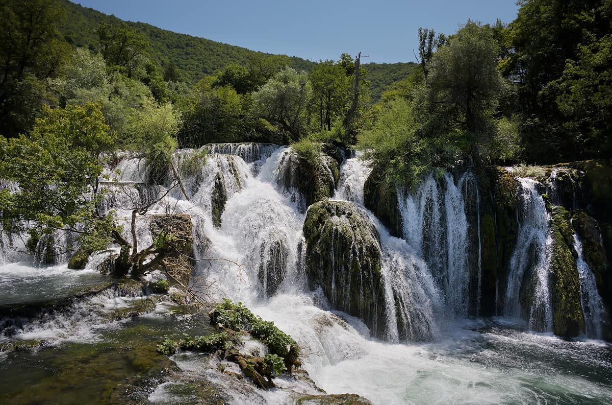
Una National Park - Upper Reach and Waterfalls
Nacionalni park Una - Gornji tok
Una-Sana Canton (Martin Brod / Štrbački buk) · Bosnia and Herzegovina
Photo: Miha Peče · CC BY-SA 4.0 · Wikimedia Commons
Breathtaking tufa waterfall cascades like Štrbački buk (24 m) incised through rugged karst mountain woodlands.
A river can sculpt its own dramatic amphitheatre. The Una does so using moss and dissolved limestone: as water cascades over ledges, aquatic mosses precipitate calcite, slowly cementing limestone barriers and forming terraced tufa dams over which the river tumbles anew. The result is the upper course of the Una in north-western Bosnia and Herzegovina, where emerald-blue currents surge through Martin Brod, Štrbački buk, Troslap, Dvoslap, and Ripač. Designated a national park in 2008—the first in the Federation of Bosnia and Herzegovina—it safeguards the valleys of the Una, Unac, and upper Sana rivers.
What makes it unique
A river that builds its own cascading waterfalls through moss and limestone, tumbling 24 metres at Štrbački buk.
The place
Nature
The landscape
The Una surges from a deep karst siphon spring at the foot of Mount Stražbenica near Donja Suvaja across the border in Croatia. Downstream to Bihać, the riverbed drops nearly 3 metres per kilometre, imbuing the upper course with an energetic mountain character: gravel islands, wild rapids, and tumbling falls.
Here lies the biological engine shaping the landscape. Where water spills over cascades, particularly between Martin Brod and Štrbački buk, massive deposits of porous calcareous tufa accumulate. Aquatic mosses coating the riverbed, adapted to trap calcium carbonate, form the indispensable catalyst. Botanists have identified 42 plant species, 25 algae taxa, and 17 aquatic bryophytes actively participating in building these living tufa barriers. Štrbački buk represents the tallest cataract; the cascade complex at Martin Brod is the most famous.
The Unac enters from an adjacent valley. Originating at 876 metres beneath Mount Šator, it cuts through the Pojila defile before joining the Una at Martin Brod through a sheer canyon descending 350 metres in depth. In hot summers upper stretches run dry as waters dive underground, surfacing at Crno Vrelo roughly 3 km above its confluence with the Una. The Krka river, a pristine tributary flowing for 5 km, traces the international border with Croatia within the park.
The entire park lies between 200 and 450 metres elevation, stretching along a north-west to south-east valley. Its tufa travertine cascades and hydrology, alongside the adjacent Korana and Krka river networks, are unique in Europe.
Wildlife and seasons
More than 1.900 plant species, representing 52,19 % of the flora of Bosnia and Herzegovina, flourish across the park. Notable endemics include the Una bellflower (Campanula unensis), named after the river, and the Bosnian lily, which graces dry limestone and serpentine meadows; yellow gentian, spotted gentian, edelweiss, and dwarf mountain pine also occur.
The park boasts rich aquatic and terrestrial biodiversity: 30 fish species, 130 bird species, and large mammals including Eurasian lynx, red fox, wolf, brown bear, and Balkan chamois. Among native ichthyofauna, the Danube salmon or huchen represents a flagship endangered predator in the upper reaches. Visiting season spans May to October.
Species
With a page in the atlas
Being mentioned in a source doesn't guarantee sightings: check with the people who manage the area.
Memory and protection
History and conservation
The Illyrian Iapydes settled the valley during ancient times, erecting pile dwellings along the riverbanks, particularly around Ripač. Centuries later, the medieval town of Rmanj arose in the late fourteenth or early fifteenth century at the confluence of the Unac and Una; Rmanj Orthodox Monastery at Martin Brod remains an important spiritual beacon at the crossroads of Bosnia, Lika, and Dalmatia. The fifteenth-century fortress of Ostrovica stood as the strongest stronghold of the upper Una before falling to the Ottomans in 1523.
The national park was established on 29 May 2008, following grassroots conservation campaigns spearheaded by local communities, first pursuing UNESCO recognition and subsequently establishing statutory protection. It encompasses 19.800 hectares. A proposed transboundary Plitvice-Una Peace Park seeks to link Una National Park directly with Croatia’s Plitvice Lakes.
Before you set off
Visiting
How to visit
The visitor zones around Štrbački buk and Lohovo feature wooden walkways, viewing platforms, and marked nature trails. Štrbački buk serves as the starting and finishing hub for the circular trail route promoted by the park; interpretive signboards detail waterfall hydrology and living tufa accretion. At Martin Brod, a settlement of medieval origin, guided walking tours lead past historic watermills and cascades. Throughout the park terrain caters generously to hiking, mountain biking, and licensed camping.
On the water, the International Una Regatta, a celebrated whitewater paddling event, launches from Martin Brod, running down through Štrbački buk.
Before you go
The most rewarding period for visits is May to October, with Štrbački buk attracting the highest visitor volumes.
Check access, rules and visiting conditions in the official information from the managing body before you set off.
Location
Where it is and how far it reaches
Boundary of Una · IUCN II · © EEA, CDDA (CC-BY) The coordinate is estimated; it isn't a verified access point.
Transparency
Sources
The research data with its sources, and the official links for this place, are in the Spanish version of this page. See the Spanish version
Around it
Just 3 km away lies the Source of the Una, a declared natural monument; eleven kilometres away stands Lom Primeval Forest; and twenty-five kilometres away rises Dinara Nature Park. Further afield, Tara River Canyon and Durmitor Mountain Massif share huchen, wolves, and bears with the Una, while Dunajec Gorge shares huchen and a canyon river habitat.
What else to explore nearby
Approximate straight-line distance between the edges of each area. It doesn't indicate access, routes or driving times.
- Lom Primeval Forest Strict Nature Reserve
Republika Srpska (Petrovac / Klekovača)
About 11 km away
Beech and fir reserve set upon the deep karstic terrain of Mount Klekovača.
JFMAMJJASONDJune – October · Crowding very low
- Dinara Nature Park
Šibenik-Knin and Split-Dalmatia Counties (Knin / Sinj)
About 25 km away
The massif that gives its name to the entire Dinaric Alps and hosts Croatia’s highest peak (Dinara 1,831 m).
JFMAMJJASONDMay – October · Crowding very low
If you like this place, elsewhere in Europe
Distant places with uncommon wildlife and habitats in common. The most widespread species don't count. Sharing species doesn't imply a corridor or guaranteed presence.
- Retezat National Park
Hunedoara County (Hațeg)
In common: Gentiana lutea · Leontopodium alpinum · Brown bear
The realm of the granitic and glacial Retezat, with over 80 crystal tarns and the Gemenele scientific reserve.
JFMAMJJASONDJune – October · Crowding low
Entry #207 of the original atlas.