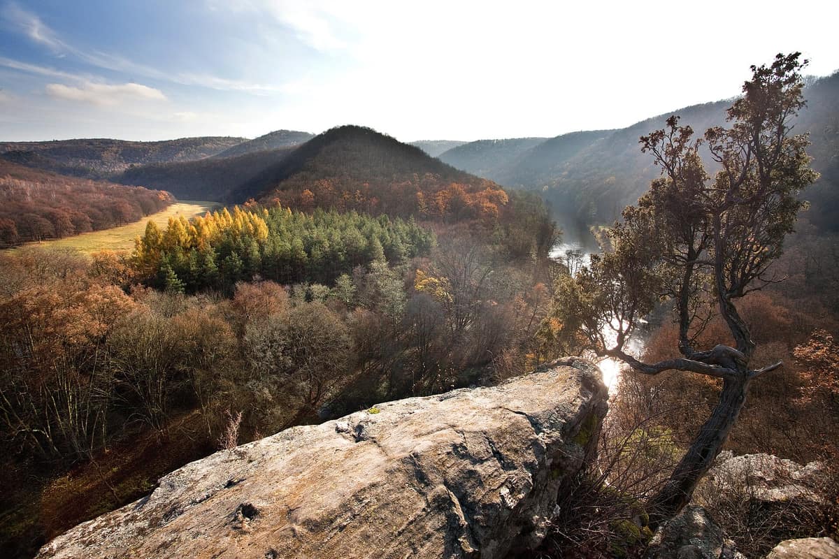
Thayatal / Podyjí National Park
Nationalpark Thayatal - Národní park Podyjí
Lower Austria (Hardegg) / South Moravia (Znojmo) · Austria / Czechia
Photo: Byliusrx · CC BY-SA 3.0 at · Wikimedia Commons
Incised meanders of the Thaya/Dyje River flanked by hillside beechwoods and thermophilous rocky crags.
In 1989 the Iron Curtain fell, allowing the Thaya, which marks the border between Austria and the Czech Republic, to transform from a heavily fortified frontier into a shared river valley. What was protected thereafter are two seamlessly connected national parks: Thayatal on the Austrian side, founded in 2000, and Podyjí across the water, designated in 1991. Together they protect some 7.700 hectares of a canyon where the river, known as Thaya or Dyje, has carved 23,3 km of looping meanders, with the river itself defining the national boundary.
What makes it unique
Here a political border runs down the middle of a river and yet does not divide the ecosystem: it is one of Central Europe's last near-natural river valleys.
The place
Nature
The landscape
Between 5 and 1,5 million years ago, the Thaya carved deeply into the metamorphic bedrock of the Bohemian Massif to depths of up to 150 m, shaping one of Central Europe's most beautiful epigenetic breakthrough valleys. The bedrock consists of granite, gneiss and schist dating back up to 600 million years, forming Austria's oldest geological range. The most celebrated bend lies near Merkersdorf, where the river loops almost entirely around the Umlaufberg—the 378 m "meander mountain"—separated by a narrow rocky ridge only some 120 m across. From its summit you survey the whole valley.
The gorge sits directly on a climatic frontier between the humid Atlantic Waldviertel and the warm Pannonian Weinviertel, blending plant and animal communities from southeastern Europe, the Alpine foothills and Central Europe. More than 90% of the park is cloaked in woodland: warm, dry oakwoods on acidic granite in the east, and lush beechwoods in the west. Rocky ledges and precipitous crags host dry steppe grasslands, botanical treasures ranging from cliff chasmophytes to open wood-pastures. The park's wildflower meadows, covering some 63 ha, boast wild orchids, Carthusian pinks and meadow clary, mown using insect-friendly cutter bars once or twice a year from mid-June onwards.
Wildlife and seasons
The seasons orchestrate life here. In late February or early March, the first snowdrops emerge, followed by woodland floors carpeted in liverleaf, mezereon, lungwort and primroses. The southern slope of the Überstieg turns yellow with blossoming cornelian cherries. In mid-March the black stork returns from Africa, frequently observed foraging along the Thaya around the Umlaufberg or fishing between Hardegg and the Überstieg, especially in early morning. The park hosts eight of Austria's ten woodpecker species, and along the Einsiedler trail many trunks bear telltale signs of the black woodpecker.
In summer at dawn, dice snakes and Aesculapian snakes (Esculapio) emerge onto sunny crags alongside vibrant green lizards. In early May these emerald lizards court on rocky outcrops of the Überstieg and the Max Plateau. White-throated dippers and grey wagtails forage along the water's edge, while with a little luck a common kingfisher flashes across the stream. The pristine rivers provide a crucial sanctuary for the endangered noble freshwater crayfish.
Autumn arrives with glowing orange birches and blazing red maples. The sole flower of this late season is the autumn crocus (meadow saffron), which blooms in autumn while producing leaves in April. Visitors are encouraged to sample wild fruits without picking them, while mushroom gathering is strictly prohibited.
The European wildcat represents the park's crowning discovery: in 2007 it was genetically verified here via DNA for the first time in 35 years in Austria. Glimpsing one in the wild is nearly impossible, but Frieda and Carlo, two wildcats, live in Austria's largest wildcat enclosure (450 m²), viewed directly from the visitor centre foyer.
Species
With a page in the atlas
Being mentioned in a source doesn't guarantee sightings: check with the people who manage the area.
Memory and protection
History and conservation
The fall of the Iron Curtain in 1989 made cooperation possible, and soon after the parks of Podyjí (1991) and Thayatal (2000) were born. On 15 July 1999, ministers from Austria and the Czech Republic and the governor of Lower Austria signed a declaration of cooperation between the two parks. In their agreement appears the phrase: "the border down the middle of the river divides states, but not ecosystems".
The Austrian park occupies 1.360 ha, and Podyjí 6.300 ha, between Znojmo and Vranov nad Dyjí in South Moravia. The IUCN recognized Thayatal as Category II in 2001.
Before you set off
Visiting
How to visit
Begin at the Park House, 1,5 km from Hardegg on the way to Retz: it is the departure point for excursions and provides information from staff and rangers. The exhibition "NaturGeschichten" shows the valley from the perspective of the black stork, with a giant aerial view. From the foyer you can see the wildcat enclosure, and there are feeding presentations and a walking trail designed to follow their tracks. Excursions and events are also offered, such as "Wildnis Schnuppern", and personalized guided tours, "Rent a Ranger".
There are 100 km of trails and cycling routes in Thayatal-Podyjí. The Hennerweg is a 1,8 km themed trail, taking about 40 minutes, with six stations on forest development and deadwood; early flowers can be seen there, and in autumn the leaves of beeches and oaks.
Before you go
Remain strictly on marked trails to safeguard sensitive flora and breeding fauna. Dogs must be kept on a leash at all times. Camping, bivouacking and lighting fires are strictly forbidden throughout the park. The Thaya is not designated for swimming, and boating or kayaking is prohibited on the river within the park. Cycling is only allowed on designated cycling tracks.
Check access, rules and visiting conditions in the official information from the managing body before you set off.
Location
Where it is and how far it reaches
Boundary of Thayatal · IUCN II · © EEA, CDDA (CC-BY) The coordinate is estimated; it isn't a verified access point.
Transparency
Sources
The research data with its sources, and the official links for this place, are in the Spanish version of this page. See the Spanish version
Around it
To the northwest along the Thaya system lies the Forêt d'Anlier, Grande Forêt de Saint-Hubert, Reserva Natural da Serra da Malcata and Masivul Vlădeasa, which share rich forest and woodland species.
If you like this place, elsewhere in Europe
Distant places with uncommon wildlife and habitats in common. The most widespread species don't count. Sharing species doesn't imply a corridor or guaranteed presence.
- Jizera Mountains Beechwoods
Liberec Region (Jizera Mountains)
In common: Astacus astacus · Black stork
Spectacular mountain slope clothed in ancient beechwoods with granite outcrops, inscribed by UNESCO.
JFMAMJJASONDMay – October · Crowding low
- Bukovské Vrchy Primeval Forest Complex - NP Poloniny
Prešov Region (Snina District)
In common: Elaphe longissima · European wildcat
Slovakia’s largest tract of virgin primeval beech forests contiguous with subalpine ridge meadows (poloniny).
JFMAMJJASONDMay – October · Crowding very low
Entry #113 of the original atlas.