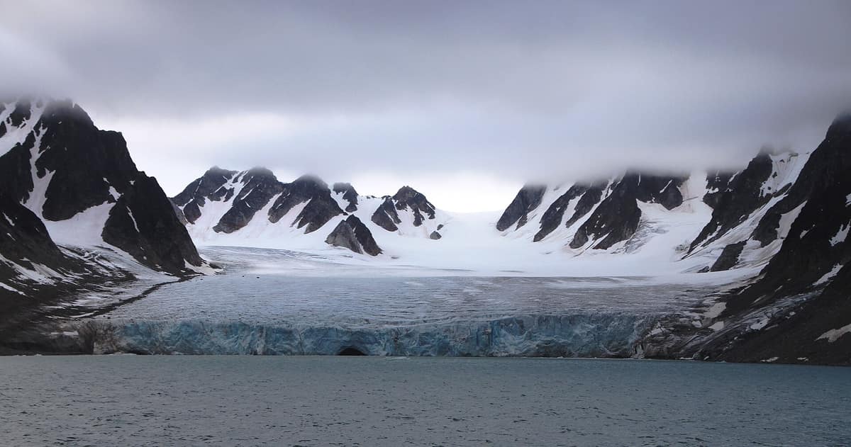
Northwest Spitsbergen National Park
Svalbard Archipelago (Spitsbergen Island / Albert I Land / Haakon VII Land) · Norway
Photo: Bjoertvedt · CC BY-SA 3.0 · Wikimedia Commons
The ultimate spectacle of the European High Arctic (79° N), with colossal tidewater glacier fronts in Magdalena and Kongsfjorden and geothermal springs at Bockfjorden.
Nearly at 80° north latitude, where maps run out of land, a fjord hides warm water welling straight from bedrock. That is the most astonishing secret of Northwest Spitsbergen National Park: the northwestern corner of Spitsbergen and the ocean embracing it. It encompasses 9.914 km², of which 3.683 are land and 6.231 are sea. More than half the park is therefore traversed by boat. Jagged alpine peaks, glaciers calving directly into saltwater, low-lying bird islands and, along lonely strands, the poignant relics of whalers who ventured here four centuries ago.
What makes it unique
Here lie the northernmost documented terrestrial thermal springs on Earth.
The place
Nature
The landscape
The park is best understood from Bockfjorden. A tectonic fault running north to south divides the terrain in two: to the west, jagged alpine horns; to the east, rounded, reddish sandstone mountains. Along the fjord shore emerge the Troll and Jotun springs, surface relicts of extinct Quaternary volcanoes. Jotun emerges at 24,5 °C and Troll at 28,3 °C, with their mineral travertine terraces supporting a unique botany: warmth-loving plants, some representing their sole population across Svalbard, including alpine eyebright and sibbaldia.
Toward the northeast the topography levels out. Reinsdyrflya in Haakon VII Land is Svalbard's largest strandflat plain. And amid the bare rock plunge colossal glaciers: Lilliehöökbreen in the west calvings into Krossfjorden, while Monacobreen in the east tumbles into Liefdefjorden.
The coastal climate is softened by the sea. It is High Arctic tundra, yet warm branches of the West Spitsbergen Current keep western fjords ice-free throughout most of the year.
Wildlife and seasons
The park is prime polar bear domain: it serves as an important wintering and hunting area, which is why anyone traveling beyond settlements must carry polar bear deterrents and firearms. The walrus, Svalbard caribou and Arctic fox also reside here; several rivers support populations of Arctic char.
Birdlife constitutes the supreme glory of this coast. One-third of the area—cliffs, islands and shorelines—is designated an Important Bird Area for breeding barnacle and brent geese, common eiders and Arctic terns. Moseøya, Skorpa and Guissezholmen are strict bird sanctuaries where eiders and geese nest; Reinsdyrflya concentrates thousands of staging waterbirds.
Moffen, a low gravel atoll just north of Wijdefjorden, is a renowned walrus haul-out and bird breeding sanctuary. Expedition vessels cruise by for its high latitude, but landing on the island or entering its territorial waters is strictly prohibited.
Species
With a page in the atlas
Being mentioned in a source doesn't guarantee sightings: check with the people who manage the area.
Memory and protection
History and conservation
The park was established by royal decree on 1 June 1973, protecting land and sea, glaciers, avian havens and historical monuments.
Human history lines the strands. Smeerenburg was a seventeenth-century Dutch whaling station on Amsterdamøya, founded around 1620 and abandoned around 1660 as local whale stocks plummeted. Today researchers record seven blubber ovens, 19 building foundations and 101 graves there. At Gravneset lie the graves of some 130 early whalers. At Virgohamna on Danskøya, Swedish engineer S. A. Andrée took off in 1897 in a hydrogen balloon aiming for the North Pole; relics of that tragic voyage and later airship expeditions still rest on the tundra.
Before you set off
Visiting
How to visit
The park is explored by sea, with zodiac landings at designated historical and natural sites. The two most famous landing sites are Smeerenburg and Virgohamna, and in summer the park receives regular expedition cruise traffic. Magdalenefjorden is among the most visited natural fjords in Svalbard outside settlements.
Strict landing regulations apply: tourism ashore is only permitted at officially mapped sites, accompanied by qualified guides versed in natural and cultural heritage, with strict caps on group numbers ashore at any one time.
Before you go
All cultural heritage traces predating 1946 are legally protected: it is strictly forbidden to damage, disturb or remove anything. At Likneset, Ebeltofthamna and parts of Ytre Norskøya, year-round access prohibitions apply. Camping requires prior permission from the Governor, requested four weeks in advance with mandatory polar bear sentry duties. From 1 July 2027, certified Svalbard guides will be mandatory. Check current regulations on the Governor's website before travel.
Check access, rules and visiting conditions in the official information from the managing body before you set off.
Location
Where it is and how far it reaches
Boundary of Nordvest-Spitsbergen · IUCN II · © EEA, CDDA (CC-BY) The coordinate is estimated; it isn't a verified access point.
Transparency
Sources
The research data with its sources, and the official links for this place, are in the Spanish version of this page. See the Spanish version
Around it
The closest counterparts in the atlas lie within the same archipelago. The Søraust-Svalbard Nature Reserve shares polar bear, walrus and caribou, alongside glaciated Arctic coastlines. The Nordaust-Svalbard Nature Reserve also shares polar bears and walruses.
If you like this place, elsewhere in Europe
Distant places with uncommon wildlife and habitats in common. The most widespread species don't count. Sharing species doesn't imply a corridor or guaranteed presence.
- Søraust-Svalbard Nature Reserve
Svalbard Archipelago (Edgeøya and Barentsøya Islands)
In common: Polar bear · Walrus · Caribou — glacial landscape, wild coast, marine
The vast desert tundra islands of Edgeøya and Barentsøya (21.800 km²), a premier denning sanctuary for polar bears and massive walrus haul-outs.
JFMAMJJASONDJuly – August · Crowding none
- Northeast Svalbard Nature Reserve
Svalbard Archipelago (Nordaustlandet Island / Kvitøya)
In common: Polar bear · Walrus — glacial landscape, wild coast, marine
Norway's largest strict nature reserve (55.000 km²), dominated by the Austfonna ice cap (Europe's largest ice cap outside Greenland).
JFMAMJJASONDJuly – August · Crowding none
Entry #608 of the original atlas.