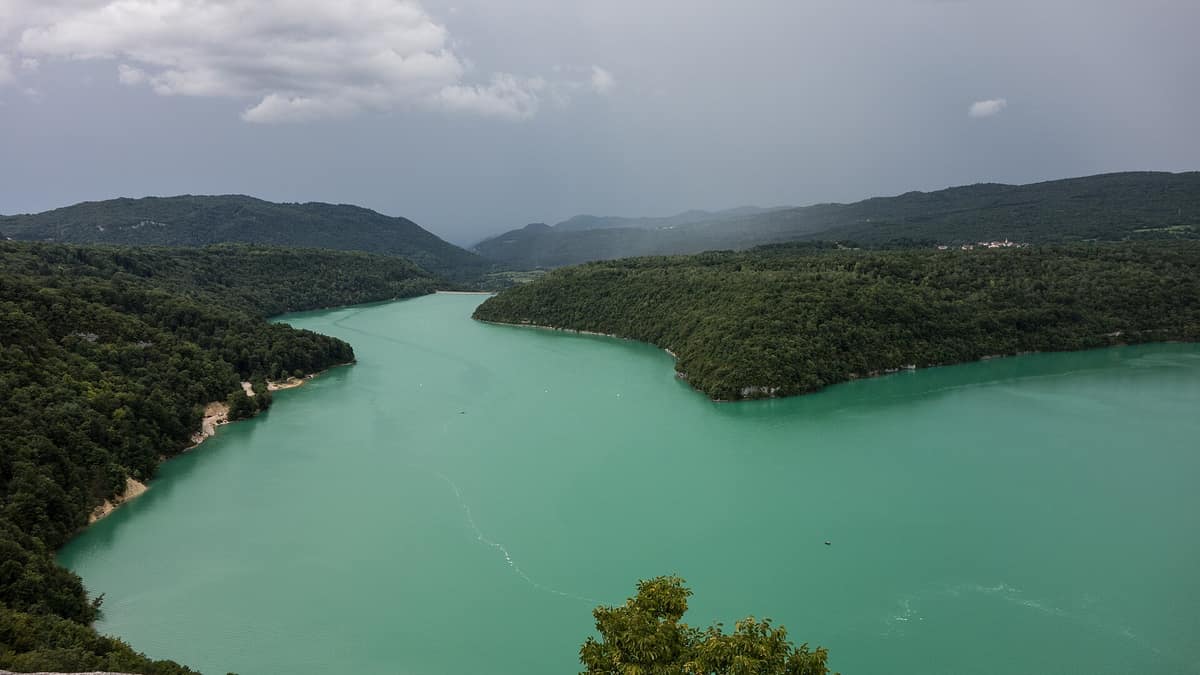
Haut-Jura Regional Nature Park
Parc Naturel Régional du Haut-Jura
Jura / Ain / Doubs (Saint-Claude / Les Rousses) · France
Photo: Annick Monnier · CC BY-SA 4.0 · Wikimedia Commons
The highest crests of the Jura Range (Crêt de la Neige 1,720 m) with ancient spruce forests and peat bogs.
Around a hundred capercaillies live in the forests of the Haut-Jura, a species threatened with extinction, and much of what you see here revolves around avoiding disturbing them. The Haut-Jura Regional Nature Park was created on 10 February 1986 in the south-west of the Jura massif along the Swiss border, and today unites municipalities from three departments—Ain, Doubs and Jura—covering some 178,000 hectares. Forests blanket 70% of its area, grazed beneath their canopy mainly by Montbéliarde dairy cattle: an inhabited mountain of woodland, water and meadows.
What makes it unique
A mid-mountain world of forests, peatlands and combes where capercaillie and lynx still find refuge and where hikers learn to tread lightly.
The place
Nature
The landscape
Water is ubiquitous, sculpting the rock and feeding numerous rivers and waterfalls. The massif forms undulating plateaus from 700 to 1,000 m dissected by deep combes and by cluses—natural transverse valleys linking one vale to another without crossing a high pass. Landscapes shift distinctly from one sector to the next.
In the Montagne Pliée, between 950 m and Mont d'Or (1,460 m), ridges, combes and valleys alternate; broad, flattened summits serve as summer mountain pastures. Crêt Pela, at 1,495 metres, is the highest point in the Jura department, with summits broader than the valleys and the characteristic wooded-pasture scenery of the prés-bois. Crêt de la Neige, at 1,718 m, crowns the ridge line of the Jura; the territory drops down towards Switzerland with an elevation difference exceeding 1,000 m. The lakes and bogs in the lower basins of the Grands Vaux remain poles of extreme cold during bitter winters.
Wildlife and seasons
The forest is home. Among the most emblematic species are the lynx and the capercaillie, alongside lesser-known treasures such as the white-clawed crayfish and wild orchids. The capercaillie feeds on spruce needles. To protect it during its most vulnerable season, certain forest sectors are closed to the public from 15 December to 30 June: an annual regulatory restriction.
With such elusive wildlife, the most rewarding way to experience the woods is reading their tracks. The interpretive trail invites you to search for signs of chamois, roe deer, red deer, fox and lynx rather than expecting direct sightings, as animals slip away upon hearing human footsteps; some can hear from several metres away and flee before you ever spot them. In June and July, along Crêt Pela, the southern marsh orchid may be found.
Species
With a page in the atlas
Being mentioned in a source doesn't guarantee sightings: check with the people who manage the area.
Memory and protection
History and conservation
The park views forest ecosystems as biodiversity reservoirs and actively promotes a wide variety of tree species and vegetation layers. Conservation here is above all an art of coexistence with farmers, foresters and wildlife. The Valserine river, flowing through Ain and Jura, holds the prestigious «wild river» certification.
Before you set off
Visiting
How to visit
For an easy start, the Sentier des Explorateurs in Prémanon is a gentle circuit taking about one hour, 2 km long with 71 m of elevation gain, designed by schoolchildren for families eager to explore nature. The Crêt Pela route leads through forest habitat protected by regulation due to the presence of sensitive species.
The park offers a vast network of routes. Haut-Jura Rando gathers itineraries on foot, mountain bike and snowshoes across various distances and grades, while the park’s main roaming trail features 7 itineraries with numerous loop variants on foot, snowshoes, cross-country skis, mountain bike or horseback. For cycling, there are 44 signposted routes encompassing 1,500 km of quiet backroads and lanes and over 100 sights of interest, with e-bikes available for hire. In winter, the park provides an interactive map for Nordic skiing, snowshoeing and sled dog trails.
The Maison du Parc in Lajoux serves as both park headquarters and visitor hub: it hosts the permanent exhibition «Haut-Jura, Terre Vivante!» exploring landscapes, wetlands and forests, and the Grenier-Fort, a traditional wooden vault-granary in the garden. In the screening room you can listen to «The Song of the Risoux Forest», a sound immersion spanning eight decades based on the park’s ecoacoustic studies. Les Rendez-vous du Parc offer free guided nature walks, lectures, film screenings and workshops for families to discover the mountain.
Before you go
The park calls this the Quiétude attitude: eight simple practices for enjoying outdoor recreation while respecting natural environments and the people working within them. Many paths traverse private property where grazing cows produce the milk for renowned Jura cheeses like Comté. Bivouacking between 19 h and 9 h is generally permitted, though certain zones have specific restrictions or bans. When hiking with a dog, rules vary by sector along the trail; elsewhere keeping dogs leashed is advised. If you encounter livestock guardian dogs, find out where herds are grazing beforehand, stay on marked routes, remain calm, stop walking and avoid eye contact.
Check access, rules and visiting conditions in the official information from the managing body before you set off.
Location
Where it is and how far it reaches
Boundary of Haut-Jura · IUCN V · © EEA, CDDA (CC-BY) The coordinate is estimated; it isn't a verified access point.
Transparency
Sources
The research data with its sources, and the official links for this place, are in the Spanish version of this page. See the Spanish version
Around it
Bordering the park are the Haute Vallée de l'Ain (0 km) and the Parc Naturel Régional Jura Vaudois (1 km); further out, La Loue - Vallée et Gorges (15 km) and, beyond that, the Gorges du Doubs - Franco-Suisses.
What else to explore nearby
Approximate straight-line distance between the edges of each area. It doesn't indicate access, routes or driving times.
- Jura Vaudois Nature Park
Canton of Vaud (Saint-Cergue / Le Marchairuz)
About 1 km away
Beech and pine-clad hills across morainic karst terrain overlooking Lake Geneva and the Mont Blanc massif.
JFMAMJJASONDMay – October · Crowding low
- Gorges of the Doubs River
Doubs (FR) / Canton of Jura (CH)
About 26 km away
A meandering river canyon marking the natural frontier between France and Switzerland with limestone cliffs and cascading falls.
JFMAMJJASONDMay – October · Crowding low
Entry #332 of the original atlas.