Puez-Odle Natural Park / Naturpark Puez-Geisler
Parco Naturale Puez-Odle / Naturpark Puez-Geisler
South Tyrol (Val Gardena / Val di Funes / Santa Cristina) · Italy
Photo: Bops92 · CC BY-SA 4.0 · Wikimedia Commons
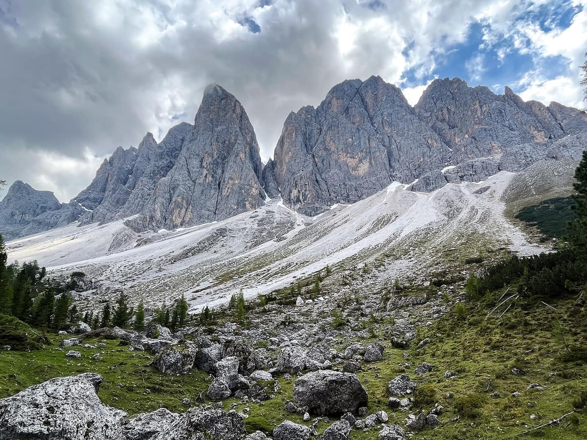
The razor-sharp dolomitic spires of the Odle/Geisler towering above the alpine pastures of Val di Funes.
There are mountains to look at and mountains to read. Puez-Odle is meant to be read: across its walls are stacked, one upon another, almost all the rock layers that define the Dolomites, turning the entire park into an open-air textbook of geology. Between the Isarco, Pusteria, Badia, and Gardena valleys rise two massifs, the Puez and the Odle, with dolomitic towers soaring up to 3.025 m at Furchetta and Sass Rigais.
What makes it unique
Within a single park lie all the rock types and typical strata of the Dolomites, from the porphyry basement to Jurassic and Cretaceous sediments.
The place
Nature
The landscape
It begins from below, because that is how it was formed. The crystalline basement of the Dolomites consists of porphyries and phyllites, upon which settled a sandstone that crops out near Sass de Putia. Then came the sea: the Bellerophon layer was built from the shells of a marine gastropod of the ancient Tethys Ocean, reaching several hundred metres in thickness in places. Over it rests the Werfen formation, and atop that, dolomite, the signature rock of the region.
Dolomite dominates the scenery. Sciliar Dolomite carves pinnacles and towers in the Odle di Funes; the paler Principal Dolomite appears at Crespeina, across the Gardenaccia, and around the Puez, where karst processes open numerous sinkholes and fissures. Higher still lies the Raibl formation, rich in fossils and vivid in colour across the panorama; being impermeable, it protects the underlying dolomite and feeds spring systems, as seen in Vallunga. The youngest sediments date from the Jurassic and Cretaceous, also laden with fossils, imparting hues from red to green in formations such as Col de Muntijela and Col de la Soné.
The outcome is a landscape of bare stone: almost the entire park is dolomite and scree, with woodland pushed to the outer rims. Pastures, meadows, and high-altitude alpine turf of sedges and blue-tinted grasses predominate. The park's most celebrated valleys are Vallunga, Val Chedul, Val di Lietres, Val Culea, and Val Scura.
Wildlife and seasons
Spring paints the alpine meadows. In mountain pastures bloom pasqueflower, alpine snowbell, bird's-eye primrose, and saffron crocus, while around Zanser Alm spring anemones, snowbells, primroses, and crocuses flourish early in the season. Vallunga also shelters dwarf alpenrose, lady's slipper orchid, martagon lily, and orange lily. In the open woods of Vallunga grow Norway spruce, European larch, and Swiss stone pine, with mezereon and winter heath carpeting the understorey. At extreme elevations where wind confines vegetation to the ground, sedges and blue moor-grass prevail, with edelweiss nestled in sheltered pockets.
Wildlife distributes according to topography. Red deer frequent the northern reaches of the park, chamois inhabit Vallunga and the Odle di Funes, and roe deer roam the slopes adjoining Malga di Zannes. Alpine marmot colonies occupy the western flanks of the Cirgruppe as well as Medalges Alm and Cisles Alm.
Vallunga provides sightings of the Eurasian eagle-owl and echoes with the mating call of the western capercaillie. In the pastures nest white-winged snowfinch, northern wheatear, water pipit, and black redstart; overhead across the highest summits glide alpine choughs, common ravens, and, rare yet resident, the golden eagle. In small alpine pools survive alpine newts, alpine salamanders, and viviparous lizards, while quieter forested sectors occasionally reveal the common European adder.
Species
With a page in the atlas
Being mentioned in a source doesn't guarantee sightings: check with the people who manage the area.
Memory and protection
History and conservation
The park was established in 1978 and expanded in 1999 to include the Rasciesa area belonging to the municipality of Ortisei; in 2009 UNESCO recognized it as an integral component of the Dolomites World Heritage Site. It forms part of Natura 2000, the European ecological network dedicated to conserving wild habitats and species.
Before you set off
Visiting
How to visit
The park visitor centre stands in Santa Maddalena in Villnöß, administered by the Autonomous Province of Bozen/Bolzano. Inside, visitors can walk over an aerial photograph of the territory, explore the «Touching Mountains» exhibition displaying local rocks and strata, and on the second floor discover two further rooms: the «Cabinet of Nature's Curiosities» and «Conquering Mountains».
For an easy stroll, beside Malga Zannes begins a three-kilometre nature loop, the Naturerlebnisweg Zans, fully wheelchair-accessible with a maximum gradient of 8 %. It encircles an enclosure for red deer, fallow deer, and roe deer, using interpretive stations with braille to explain the geology, ecology, and culture of the Villnöß valley. The trail leads from the car park across Piuswiese to the wildlife enclosure and returns past the historic lime kiln and Kelderer Wiese.
For longer treks, Alta Via no. 2 traverses the park from north to south, while the «Adolf Munkel Trail» traces the northern foot of the Odle group. Key mountain huts include Rifugio Firenze, Genova, Puez, Gardenaccia, Stevìa, and Malga Brogles. Geological trails throughout the park illustrate strata and rock formations across Earth's geological eras.
Before you go
Check with park authorities regarding visitor centre opening hours and the current condition of trails and alpine huts before departing.
Check access, rules and visiting conditions in the official information from the managing body before you set off.
Location
Where it is and how far it reaches
Boundary of Parco naturale Puez Odle · IUCN IV · © EEA, CDDA (CC-BY) The coordinate is estimated; it isn't a verified access point.
Transparency
Sources
The research data with its sources, and the official links for this place, are in the Spanish version of this page. See the Spanish version
Around it
The Parco Naturale Fanes-Sennes-Braies / Naturpark Fanes-Sennes-Prags lies about four kilometres away, showcasing the northern Dolomites' karst plateaus and glacial lakes. Twenty-three kilometres away sits Parco Naturale Paneveggio - Pale di San Martino.
What else to explore nearby
Approximate straight-line distance between the edges of each area. It doesn't indicate access, routes or driving times.
- Fanes-Sennes-Braies Natural Park
South Tyrol / Alto Adige (San Vigilio di Marebbe / Val Badia / Lago di Braies)
About 4 km away
The idyllic turquoise waters of Lago di Braies and the desolate karst plateaus of Fanes and Sennes encircled by dolomitic amphitheatres.
JFMAMJJASONDJune – October · Crowding moderate
- Paneveggio - Pale di San Martino Natural Park
Trentino (San Martino di Castrozza / Predazzo / Tonadico)
About 23 km away
The 'Forest of the Violins' (resonance spruce harvested by Stradivarius) beneath the spectacular dolomitic spires of the Pale di San Martino.
JFMAMJJASONDJune – October · Crowding low
Entry #540 of the original atlas.