Alto Tajo Natural Park
Parque Natural del Alto Tajo
Guadalajara and Cuenca (Castilla-La Mancha, Spain) · Spain
Photo: Pequeño Santi · CC BY-SA 4.0 · Wikimedia Commons
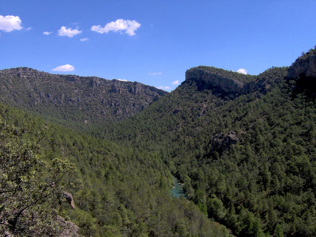
Canyons of the Tagus and Hoz Seca rivers among pine forests, riparian woodlands, and highland juniper groves.
Some rivers cross a mountain range; others slice right through it. The Tagus and the Hoz Seca do the latter: in the Sistema Ibérico, straddling south-eastern Guadalajara and north-eastern Cuenca, they have cut deep gorges into the bedrock, leaving behind a sprawling plateau of pine woodlands, windswept parameras, and sheer cliffs. Alto Tajo Natural Park is how you experience it all from top to bottom, from the high juniper stands down to the narrow green ribbons clinging to the water's edge.
What makes it unique
On a single walk you can read how water erodes rock, how it dissolves limestone, and why hard caprock stays on top while the river carves deep into the canyon.
The place
Nature
The landscape
Everything begins with water, and here water works in two distinct ways. It erodes the ground surface and dissolves the limestone. That is why the canyons of the Tagus and the Hoz Seca are fluviokarstic, and why the entire district is riddled with caves, chasms, and sinkholes: water has carved it from the inside out. Up on the heights, however, the limestone holds firm. Its horizontal, barely folded strata form the highest ridges and plateaus because it withstands surface weathering far better than softer rock. The hard caprock stays above; the river cuts below.
Drop down into the Hoz ravine and the landscape transforms. Sandstones and conglomerates are usually buried beneath harder layers of limestone, coming into view only in the gorges and river cliffs where flowing water has laid them bare.
The vegetation follows this underlying geology. Pine forests are the most widespread habitat across the entire park. You will find extensive tracts of Scots pine, black pine, and maritime pine, alongside smaller but equally valuable stands of Aleppo pine. Dominating them all is the European black pine, which covers the greatest expanse: it blankets the slopes of the Tagus canyon and the lower plateaus, especially through the central and western sectors. In the north, where elevations are lower and valleys widen, maritime pine takes over, thriving on sandstones and conglomerates alongside heathers, rockroses, and gorse. Portuguese oak, holm oak, and Pyrenean oak mingle among the pines or form pure copses.
Across the limestone parameras, vast groves of Spanish juniper stretch toward the horizon. Along streams and riverbanks, riparian woodland traces narrow green ribbons through the stone. Around local salt springs, salt-tolerant halophytic plants survive in isolated enclaves dictated by the saline soil.
Wildlife and seasons
Look up. The rock walls crowning the gorges provide nesting habitat for cliff-nesting raptors: Bonelli's eagle (endangered), golden eagle, peregrine falcon, Egyptian vulture, griffon vulture, and Eurasian eagle-owl. You can easily observe their flight from the trails without approaching nesting ledges. Small bands of Spanish ibex roam these same rocky bluffs.
Beneath the forest canopy, wildlife operates on another scale. Dense tracts of woodland shelter rich woodland bird communities and provide cover for roe deer, red deer, fallow deer, and wild boar.
The rivers harbour the most vulnerable life. Well-preserved river stretches support one of the region's healthiest populations of Eurasian otter, alongside brown trout, bermejuela, and barbel. In remote headwaters, relic populations of native white-clawed crayfish still survive, though severely declining across the region and Spain as a whole. The primary threat is the invasive American mink, which drives declines in multiple threatened native freshwater species.
The seasons reshape how you explore the river. Most rainfall falls in spring, when snowmelt swells river flows to their peak. The Campillo trail is ideal for spotting golden eagles, peregrine falcons, Egyptian vultures, and griffon vultures through spring and summer; by winter, grey herons, cormorants, and mallards take over. Mammals reveal themselves by their tracks and signs: search the Campillo dam wall for droppings left by otter, stone marten, and common genet. At dusk, out across the Villanueva de Alcorón plateau, keep an ear and eye out for red-necked and European nightjars.
Species
With a page in the atlas
Being mentioned in a source doesn't guarantee sightings: check with the people who manage the area.
Memory and protection
History and conservation
Historically, the local economy depended on transhumant pastoralism, timber, and kaolin mining. Rafters known as gancheros guided logs down the Tagus all the way to Aranjuez and Toledo. Remnants of that past still dot the landscape, including stone-walled juniper shelters (chozones sabineros) and historic salt pans at Saelices de la Sal and Armalla, enduring cultural monuments within the park.
Today the area is protected as a Natura 2000 SAC and SPA under the name Alto Tajo. Bird conservation explains motor vehicle restrictions on access tracks down into the Hundido de Armallones, preventing disturbance to nesting cliffs. Visitor pressures are managed similarly: during the summer of 2026, park authorities regulated vehicle entry points along the main canyon to mitigate severe overcrowding and ensure wildfire evacuation routes remained clear.
Rewilding projects
Before you set off
Visiting
How to visit
The park is expansive and best explored in distinct sectors. You can enter from the north via Molina de Aragón, leading on toward Orea, Peralejos de las Truchas, and Poveda de la Sierra. The visitor centre in Corduente (Guadalajara) makes an ideal starting point: it offers an interpretive exhibition, detailed guidance on the protected area's natural assets, and practical assistance in planning your route.
Further along, local centres explore different facets of the landscape. In Zaorejas, the Tagus River interpretation centre explains the river's geological origins, gorge vegetation, and cultural heritage. The Sequero de Orea focuses on traditional crafts and forest livelihoods of the Alto Tajo, while Checa houses the Museum of Traditional Livestock Farming.
For a first walk into the canyon, the Hundido de Armallones geological trail sets off from the village of Ocentejo. Other rewarding options include the 7 km Huertapelayo and Tagüenza route with designated wildlife observation stops, or the hour-and-a-half return hike to the Campillo waterfall. The park's official geological guide highlights nine distinct georoutes explaining how these landforms took shape over millennia.
Before you go
Mobile signal is absent across much of the park, particularly deep inside the Tagus canyon, so download your maps and route information beforehand. Check visitor centre opening hours: facilities in Zaorejas, Orea, and Checa open on weekends, public holidays, and long weekends from Easter through the end of October. Open fires and discarding cigarette butts are strictly prohibited throughout the park. Keep noise to a minimum so you do not disturb wildlife or other visitors.
Check access, rules and visiting conditions in the official information from the managing body before you set off.
Location
Where it is and how far it reaches
Boundary of Alto Tajo · IUCN VI · © EEA, CDDA (CC-BY) The coordinate is estimated; it isn't a verified access point.
Transparency
Sources
The research data with its sources, and the official links for this place, are in the Spanish version of this page. See the Spanish version
Around it
The Serranía de Cuenca Natural Park lies roughly 2 km away, continuing the same terrain of limestone canyons and extensive pine forests directly to the south. Near the boundary with Alto Tajo, Villanueva de Alcorón and the Altos de la Campana near Checa host free-roaming Przewalski's horses under Rewilding Spain's Iberian Highlands initiative; contact the project in advance to check visiting guidelines.
Further afield, Hoces del Río Riaza Natural Park shares with Alto Tajo similar canyon ecosystems, karst landforms, and Spanish juniper woodlands.
What else to explore nearby
Approximate straight-line distance between the edges of each area. It doesn't indicate access, routes or driving times.
- Serranía de Cuenca Natural Park
Cuenca (Castilla-La Mancha, Spain)
About 2 km away
Pine forests and deep river gorges sculpted through limestone plateaus across the Serranía de Cuenca.
JFMAMJJASONDSeptember – November · Crowding no data
If you like this place, elsewhere in Europe
Distant places with uncommon wildlife and habitats in common. The most widespread species don't count. Sharing species doesn't imply a corridor or guaranteed presence.
- Hoces del Río Riaza Natural Park
Castile and León (Segovia / Maderuelo / Montejo de la Vega)
In common: Juniperus thurifera — karst and caves, gorge and canyon
Limestone gorge hosting the historic Montejo de la Vega Raptor Refuge founded by Félix Rodríguez de la Fuente in 1975.
JFMAMJJASONDApril – June · September – October · Crowding very low
Entry #1060 of the original atlas.