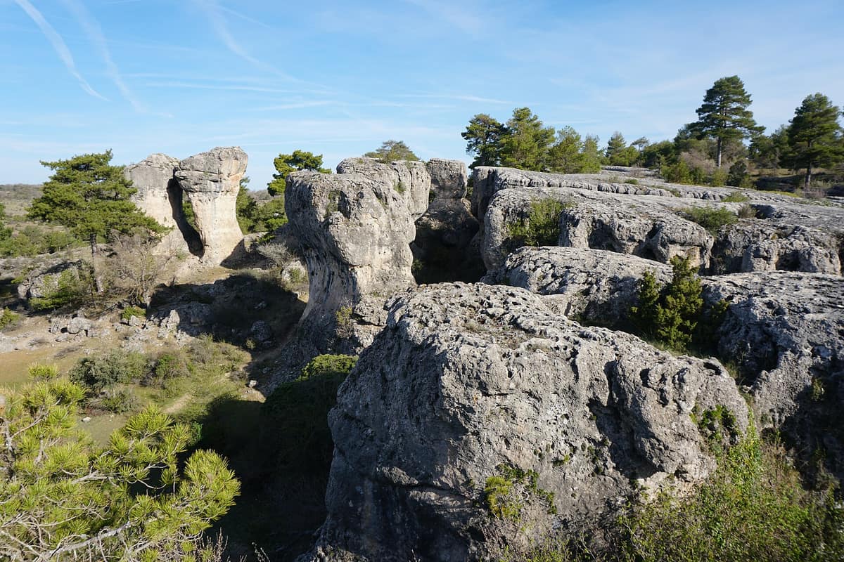
Serranía de Cuenca Natural Park
Parque Natural de la Serranía de Cuenca
Cuenca (Castilla-La Mancha, Spain) · Spain
Photo: Tanja Freibott · CC BY-SA 4.0 · Wikimedia Commons
Pine forests and deep river gorges sculpted through limestone plateaus across the Serranía de Cuenca.
Some limestone highlands look so vast and flat they seem never-ending, until suddenly they plunge. In the Serranía de Cuenca, the terrain fractures into deep gorges and river canyons carved by the Júcar and Escabas, while atop the limestone tablelands stands a city of stone: narrow alleys, ruiniform towers, and weathered limestone pavements. The Serranía de Cuenca Natural Park encompasses the northeast of the province in the Southern Iberian System, sheltering one of Spain's largest continuous tracts of natural pine forest.
What makes it unique
Here water has carved an enchanted stone city and, just a few kilometres away, impounded a mountain lagoon behind a tufa barrier: two masterpieces by the same sculptor.
The place
Nature
The landscape
Stone reigns supreme. The topography is shaped by Jurassic and Cretaceous limestones and dolomites, whose carbonate rocks dissolve under rainfall. This explains why the high tablelands, or muelas, remain relatively level, and why they are incised by dramatic river gorges and canyons wherever fractures weaken the rock. It also explains the ruiniform rock cities: spectacular limestone pavements (lapiaces) sculpted into bizarre shapes, of which the Ciudad Encantada of Valdecabras and Los Callejones de Las Majadas are premier examples. Underground, the karst reaches deep with caves and sinkholes among the most extensive in central Iberia, while in the Sierra de Valdemeca reddish sandstones and conglomerates crop out.
The park's highest elevation rises at Cerro de la Mogorrita (1.864 metres), the rooftop of the province. This position carries immense biogeographical value: as the southernmost mountain bastion of the Iberian System, it forms the divide between Atlantic and Mediterranean watersheds.
Upon this limestone bedrock thrives a grand forest. Woodlands of Scots pine, black pine, and maritime pine dominate the vegetation, interspersed with holm oak, Portuguese oak, Pyrenean oak, Spanish juniper groves, and maple thickets. Deep inside the humid canyon bottoms, the forest assumes a completely different character: relict Eurosiberian woodlands of lime, holly, and yew that reach their southern European distribution limits here. Together with the neighbouring Alto Tajo, these highlands form one of the vastest natural pine expanses in Spain.
Wildlife and seasons
Look up toward the cliffs. Across limestone escarpments and pine woodlands nest the Bonelli's eagle, golden eagle, peregrine falcon, Egyptian vulture, booted eagle, Eurasian eagle-owl, northern goshawk, and the most abundant scavenger, the griffon vulture. Forest and riparian habitats host great spotted woodpeckers, European nightjars, song thrushes, red-billed choughs, the white-throated dipper, and grey herons. At the Uña lagoon, waterbirds congregate with coots, mallards, and foraging otters.
Among mammals, native ungulates stand out: red deer, Iberian ibex, roe deer, and wild boar are indigenous, whereas fallow deer and mouflon were introduced in the mid-twentieth century. Other notable species include the red squirrel, beech marten, European badger, Eurasian otter, and European wildcat.
The rivers, headwaters of the Júcar and Tagus basins, are prime trout streams harbouring genetically pure populations of native brown trout, Mediterranean barbel, bermejuela, and chub. Upper reaches shelter key stronghold populations of native white-clawed crayfish. Among butterflies, the Spanish moon moth (Graellsia isabellae) is the most striking and relatively common. Numerous cave-dwelling bats find shelter in the subterranean karst.
Seasons transform the scenery. Autumn offers the most captivating spectacle: maples, Portuguese oaks, poplars, and willows flash bright gold against the deep evergreen pines. In winter, snow often dusts slopes down into the valleys. Spring and summer bring rich botanical blooms. At night, the sky turns remarkably pristine, ranking among the darkest in Castilla-La Mancha and well worth an outing just for stargazing.
Memory and protection
History and conservation
The natural park was established in 2007 and is designated as a Special Area of Conservation (SAC) and Special Protection Area (SPA), including critical habitat for Bonelli's eagle and the rare Atropa baetica, alongside the micro-reserve of Cueva de los Morceguillos.
Conservation challenges facing the pine forests are clearly identified: the Natura network management plan rates the status of black pine woods as excellent, but highlights forest wildfires on the Muela de la Madera as primary threats, along with excessive grazing pressure from livestock and high wild ungulate densities.
Rewilding projects
Before you set off
Visiting
How to visit
Begin at Los Callejones de Las Majadas: 3,60 km, under two hours, easy difficulty. It is an enchanting stroll among natural stone corridors and mushroom-like monoliths that invites you to imagine shapes, easily completed in half a day. For a longer journey, the El Escalerón and La Raya trail (nine kilometres, about three hours) grants bird's-eye views over the Uña lagoon, while Las Fuentecillas and Los Callejones (twelve kilometres and nine hundred metres, roughly three and a half hours) winds through oak and pine woods with Eurosiberian vegetation.
Outstanding viewpoints include the Ventano del Diablo in Villalba de la Sierra, alongside Tío Cogote and the Balcón de Pilatos in Las Majadas. At Valdemeca, a four-kilometre mycological trail taking an hour and a half demonstrates how distinct forest habitats foster exceptional mushroom diversity.
The park operates three visitor centres: Tragacete (the main centre, spanning 1.310 m² across two floors with exhibits on the protected area network, landscape, and geomorphology), Uña (dedicated to aquatic ecosystems), and Valdemeca (focused on mountain botany). The park also loans an all-terrain Joëlette trekking chair so visitors with reduced mobility can experience the trails.
Before you go
There are no drinking water fountains at Los Callejones: carry sufficient water and wear footwear suited for slippery limestone surfaces. Wild camping is prohibited, with exceptions for bivouacking and expedition trekking overnight camps, and raking forest soil when gathering mushrooms is strictly forbidden. Check operating hours for the Tragacete visitor centre before setting out.
Check access, rules and visiting conditions in the official information from the managing body before you set off.
Location
Where it is and how far it reaches
Boundary of Serrania de Cuenca · IUCN VI · © EEA, CDDA (CC-BY) The coordinate is estimated; it isn't a verified access point.
Transparency
Sources
The research data with its sources, and the official links for this place, are in the Spanish version of this page. See the Spanish version
Around it
Two kilometres away lies the Alto Tajo Natural Park, sharing the same continuous expanse of highland pine forest.
What else to explore nearby
Approximate straight-line distance between the edges of each area. It doesn't indicate access, routes or driving times.
- Alto Tajo Natural Park
Guadalajara and Cuenca (Castilla-La Mancha, Spain)
About 2 km away
Canyons of the Tagus and Hoz Seca rivers among pine forests, riparian woodlands, and highland juniper groves.
JFMAMJJASONDNo recommended season · Crowding no data
If you like this place, elsewhere in Europe
Distant places with uncommon wildlife and habitats in common. The most widespread species don't count. Sharing species doesn't imply a corridor or guaranteed presence.
- Els Ports Natural Park
Catalonia / Aragon / Valencian Community (Tarragona / Teruel / Castellón / Roquetes / Tortosa)
In common: Atropa baetica — karst and caves, gorge and canyon
A rugged karst massif between Catalonia, Aragon, and the Valencian Community featuring limestone cliffs, southern beech groves, and the Iberian ibex.
JFMAMJJASONDApril – June · September – November · Crowding low
Entry #1061 of the original atlas.