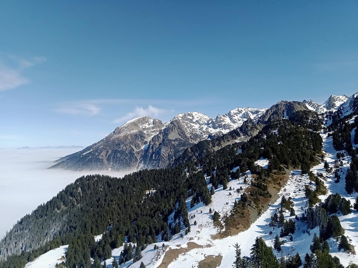
Belledonne Mountain Range
Chaîne de Belledonne
Isère / Savoie (Grenoble / Chamrousse) · France
Photo: Rémih · CC BY-SA 4.0 · Wikimedia Commons
Imposing crystalline rocky rampart without road passes soaring directly opposite the city of Grenoble.
A narrow, towering rampart of crystalline rock uncrossed by a single paved mountain pass. That is the Belledonne range, stretching between Vizille in Isère and Aiguebelle in Savoie: roughly 80 kilometres long by a mere 20 wide. Its jagged crest culminates just shy of 3,000 metres, functioning as an imposing geographical barrier between the Prealps—Chartreuse, Vercors, and Bauges—and the inner continental Alps.
What makes it unique
A largely unurbanized massif so rugged and difficult of access that it shelters species extremely rare in France.
The place
Nature
The landscape
Belledonne bears little resemblance to its neighbors. While the Chartreuse and Vercors massifs are sedimentary limestone, Belledonne forms an external crystalline massif composed of granites, amphibolites, and gneisses, displaying sharper, more severe relief, sheer scree slopes, and sparse vegetation. Its bedrock stems from the Carboniferous Hercynian orogeny, older than neighboring limestones, though elevated into its present alpine heights during later Alpine tectonics. The western slopes falling toward the Isère Valley feature stepped foothill balconies and gradual approaches, whereas the eastern face drops precipitously into the deep cleft of the Romanche Valley. Its highest summit is the Grand Pic de Belledonne at 2,977 metres.
The range ascends through distinct ecological zones. The nival zone is a domain of bare rock, cliffs, and frost-shattered scree with sparse vegetation, where Plumier's bittercress clings to damp fissures as a protected pioneer plant. Nine shrinking glacierets persist—only one retaining active crevasses—melting rapidly under climatic warming to expose virgin proglacial soils. The alpine zone is virtually devoid of trees aside from mountain pine and Swiss stone pine, punctuated by oligotrophic, nutrient-poor glacial tarns of high vulnerability and scenic allure. The subalpine zone (1,400 to 1,800 metres) is draped in coniferous forests, dominated by Norway spruce covering over half the range, interspersed with acidic mountain bogs. Below, the Balcons de Belledonne (400 to around 900 metres) alternate traditional hamlets, mixed deciduous woodlands, grazed pastures, and dry calcareous meadows rich in orchids.
The mountain climate brings abundant Atlantic-influenced rainfall, far wetter than the inner Alpine rain shadows, with contrasting exposures generating diverse microclimates.
Wildlife and seasons
Because extreme topography has curtailed human development, Belledonne stands as a biodiversity reservoir. In the alpine tier, across boulderfields and dwarf-shrub heaths, reside the Alpine ibex, rock ptarmigan, and black grouse; spotted nutcrackers harvest pine nuts in stone pine copses, while the alpine newt and common frog breed in high wetlands. Black grouse also lek across high-altitude pastures. The grey wolf has firmly re-established permanent pack territories.
Subalpine peat bogs shelter round-leaved sundew, cranberries, amphibians, northern emerald and spearhead dragonflies, alongside cave-roosting bats like Schreibers's bent-winged bat. A biological responsibility assessment by Espace Belledonne, which since 2024 has evaluated mammals, birds, amphibians, reptiles, bats, dragonflies, and vascular flora, identified sixty species of high or very high regional conservation responsibility, predominantly montane specialists.
Species
With a page in the atlas
Being mentioned in a source doesn't guarantee sightings: check with the people who manage the area.
Memory and protection
History and conservation
Belledonne has long fostered mountain industry. Iron mining and smelting at Allevard and Les Hurtières began before the eleventh century, waning in the late nineteenth and early twentieth centuries; restored sites and interpretive trails now highlight this industrial heritage.
Pastoralism profoundly shapes the open landscape: some 31 alpine commons (alpages) covering 10,674 hectares of summer pastures accommodate 1,200 cattle and 12,400 sheep each spring for 100 to 120 days. This transhumance preserves open subalpine grasslands and associated biodiversity, with wolf predation presenting an ongoing operational challenge. Beside ancient woodlands currently being inventoried, the range preserves 216 distinct wetland complexes totaling 957 hectares. Several sectors are classified under Natura 2000 or as Sensitive Natural Areas. Since the 2020 lockdowns, recreational pressure from trail running, trekking, and ski mountaineering has intensified, prompting new management frameworks to balance use and conservation.
Before you set off
Visiting
How to visit
The definitive traverse is the GR 738 (Haute Traversée de Belledonne), which spans the entire crest from Aiguebelle to Vizille, traditionally celebrated as the "Trail of the Shepherds" for its pastoral heritage. Widely regarded as one of the finest and most demanding mountain footpaths in France, it provides an uncompromising wilderness experience. For day visitors, network trails link high pastures, old-growth forests, and alpine cirques, complemented by cultural circuits exploring historic hamlets.
Vantage points overlook the Isère Valley, the Maurienne trench, and the Eau d'Olle gorge, with panoramas reaching the Chartreuse, Bauges, Vanoise, Grandes Rousses, and Taillefer massifs. For backpackers, bivouacking is tolerated across most sectors, but subject to local bylaws: check boundaries regarding private lands, pastoral herds guarded by livestock dogs, fragile wetlands, and helipad drop zones. Consult refuge wardens and shepherds beforehand.
Before you go
In southern Belledonne from Grand Colon to Arselle open campfires are banned, though portable camping stoves are permitted. From 15 June to 15 September lighting fires, smoking, and discarding cigarette ends are strictly prohibited in and within 200 metres of woodlands. Maintain respectful distances from sheep flocks and guardian dogs.
Check access, rules and visiting conditions in the official information from the managing body before you set off.
Location
Where it is and how far it reaches
Boundary of Chaîne de Belledonne · © OpenStreetMap contributors (ODbL) The coordinate is estimated; it isn't a verified access point.
Transparency
Sources
The research data with its sources, and the official links for this place, are in the Spanish version of this page. See the Spanish version
Around it
Belledonne is encircled by major Alpine reserves: fifteen kilometres away lies Parc National des Écrins, twenty-one kilometres to the south rises the massif du Dévoluy, and twenty-seven kilometres eastward stretches Parc National de la Vanoise.
What else to explore nearby
Approximate straight-line distance between the edges of each area. It doesn't indicate access, routes or driving times.
- Écrins National Park - Alpine Massif
Auvergne-Rhône-Alpes / Provence-Alpes-Côte d'Azur (Isère / Hautes-Alpes)
About 15 km away
The glaciated core of the French Alps (Barre des Écrins 4.102 m), with deep glacial valleys such as Valgaudemar and Vénéon.
JFMAMJJASONDJune – October · Crowding low
- Dévoluy Massif
Hautes-Alpes (Saint-Étienne-en-Dévoluy)
About 21 km away
Mineral karst fortress rimmed by limestone cliffs and riddled with deep subterranean chasms (chourums).
JFMAMJJASONDJune – October · Crowding very low
- Vanoise National Park
Auvergne-Rhône-Alpes (Savoie)
About 27 km away
France's first national park (1963), created to save the Alpine ibex: glaciers, alpine grasslands, and one of the Alps' greatest ibex populations.
JFMAMJJASONDJune – September · Crowding moderate
Entry #330 of the original atlas.