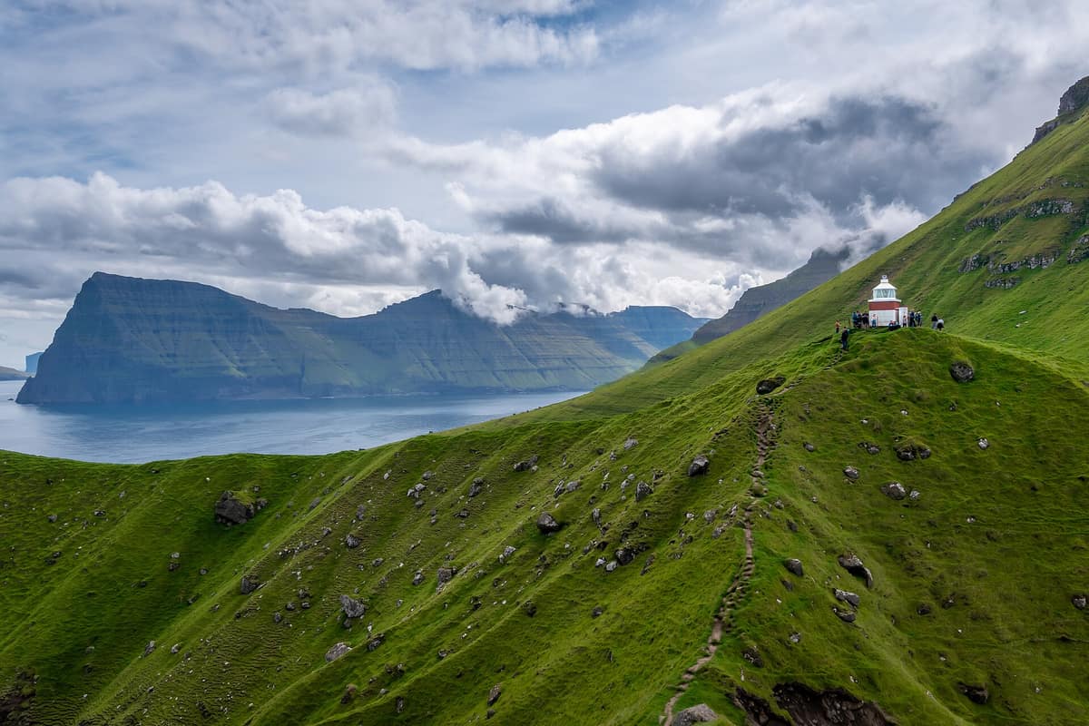
Kalsoy Island and Kallur Lighthouse
Kalsoy
Faroe Islands (Trøllanes / Mikladalur) · Faroe Islands
Photo: Ekrem Canli · CC BY-SA 4.0 · Wikimedia Commons
Narrow flute-shaped island 18 km long with 13 mountain peaks and the iconic Kallur Lighthouse perched above 200 m sea cliffs.
Four dark unlit tunnels, a winding narrow road, and at the end of the last mountain pass, a solitary white lighthouse perched before a sheer drop of sea cliffs. Kalsoy, in the northeastern Faroe Islands, is an island so long and slender that Faroese locals nickname it "the flute", owing to its narrow silhouette and the road tunnels that perforate its ridges. No bridge, undersea tunnel, or causeway links it to neighbouring islands: you arrive by boat, which preserves its timeless serenity. Between its 13 mountain peaks and 11 valleys, four historic hamlets nestle along its sheltered eastern flanks.
What makes it unique
Known as the flute island, where the lone road threads through single-lane tunnels to reach an isolated lighthouse at the cliff edge.
The place
Nature
The landscape
Kalsoy has two contrasting faces. Its western coast is unbroken rock: sheer, precipitous sea cliffs running the entire length of the island that harbour massive seabird colonies. In contrast, the eastern slopes are greener and more gently terraced, sheltering four villages in their valleys: Húsar, Mikladalur, Syðradalur, and Trøllanes, joined by a single road pierced by four mountain tunnels. Among them, the northernmost tunnel leading to Trøllanes is narrow, damp, and chilly, stretching for more than two kilometres with minimal vehicle traffic.
The place-names echo local geography. Kalsoy translates as "man's island", standing in contrast to neighbouring Kunoy, "woman's island", named after their northern capes, Kallurin and Konan. Part of the Kallurin headland collapsed into the Atlantic long ago. The island's two highest summits are Nestindar and Botnstindur.
Wildlife and seasons
Kalsoy is fundamentally an island of pelagic seabirds. Its northern and western cliffs are designated an Important Bird Area: breeding grounds for roughly 40,000 pairs of Atlantic puffins, 5,000 pairs of European storm petrels, and 200 pairs of black guillemots. Near the lighthouse at Kalvík thrives one of the largest colonies of black-legged kittiwakes in the Faroes. While cliff nesters throng the northern heights, the rest of the island supports breeding meadow birds such as golden plovers and whimbrels.
On land, terrestrial fauna is sparse. The only wild mammal is the mountain hare, and the island is free of mice and rats, despite their presence on neighbouring isles. Rare arctic-alpine plants cling to crevices around Galvin and the northern cliffs.
Species
With a page in the atlas
Being mentioned in a source doesn't guarantee sightings: check with the people who manage the area.
Memory and protection
History and conservation
Kalsoy is steeped in local folklore, most notably the haunting legend of the Seal Woman (Kópakonan) of Mikladalur. The villages are ancient: Mikladalur and Húsar are first documented in the fourteenth-century Sheep Letter. By contrast, Trøllanes remained isolated until 1985 when the final road tunnel was blasted through the mountain, ending centuries of perilous boat landings. Today these settlements preserve traditional Faroese rural life between towering cliffs, green terraces, and the open North Atlantic, sustained by sheep farming.
Before you set off
Visiting
How to visit
The undeniable highlight is the hike out to Kallur Lighthouse at the northern promontory. Setting off from Trøllanes, it is graded moderately easy and the round trip typically takes between an hour and a half and two hours. The lighthouse, dating from 1927, perches dramatically before the drop, offering breathtaking views across to Kunoy and Viðoy, crowned by Kunoyarnakkur and the precipice of Cape Enniberg. The hike requires a mandatory hiking fee for unguided visitors.
To reach the island, a vehicle and passenger ferry links Klaksvík to Syðradalur pier. A 17 km road with four tunnels connects Syðradalur with Trøllanes. Given the narrow single-track tunnels and scarce parking, the official tourist board advises taking the local bus service connecting the ferry slip with Húsar, Mikladalur, and Trøllanes. You can also walk through the tunnels, but since all four lack lighting, bringing a headlamp is essential. The historic overland route from Mikladalur to Trøllanes is a hazardous pass best avoided.
Before you go
Carry a bright torch or headlamp for the road tunnels and wear sturdy waterproof hiking boots. Before setting out, check the ferry schedule and connecting bus times, verify the Kallur hiking fee, and review the weather forecast.
Check access, rules and visiting conditions in the official information from the managing body before you set off.
Location
Where it is and how far it reaches
Boundary of Kalsoy · © OpenStreetMap contributors (ODbL) The coordinate is estimated; it isn't a verified access point.
Transparency
Sources
The research data with its sources, and the official links for this place, are in the Spanish version of this page. See the Spanish version
Around it
Just nine kilometres across the sound, the island of Viðoy shares sheer cliffs and seabird colonies with Kalsoy, while twelve kilometres away rises Slættaratindur. Twenty-five kilometres to the southwest lie the Vestmanna Bird Cliffs.
Further across the North Atlantic, St Kilda, Hornstrandir Nature Reserve, and Lundy Island share northern fulmars and Atlantic puffins with Kalsoy.
If you like this place, elsewhere in Europe
Distant places with uncommon wildlife and habitats in common. The most widespread species don't count. Sharing species doesn't imply a corridor or guaranteed presence.
- St Kilda Archipelago - Hirta and Dùn
Scotland (Outer Hebrides / Hirta)
In common: Northern fulmar · Atlantic puffin — wild coast, marine, high mountain
The only Dual (Cultural and Natural) UNESCO World Heritage Site in the UK, with sheer sea cliffs and sea stacks hosting the world's largest gannet colony (Stac an Armin 196 m).
JFMAMJJASONDJune – August · Crowding very low
- Hornstrandir Nature Reserve
Westfjords (Ísafjörður)
In common: Northern fulmar · Atlantic puffin — wild coast, high mountain
An arctic peninsula abandoned in the fifties, without roads, where the arctic fox lives without hunting and without fear.
JFMAMJJASONDJune – August · Crowding none
- Lundy Island
England (Devon / Bristol Channel / Ilfracombe)
In common: Northern fulmar · Atlantic puffin — wild coast, marine
Granite plateau 5 km in length in the Bristol Channel, the first designated Marine Conservation Zone in the United Kingdom.
JFMAMJJASONDMay – September · Crowding low
Entry #604 of the original atlas.