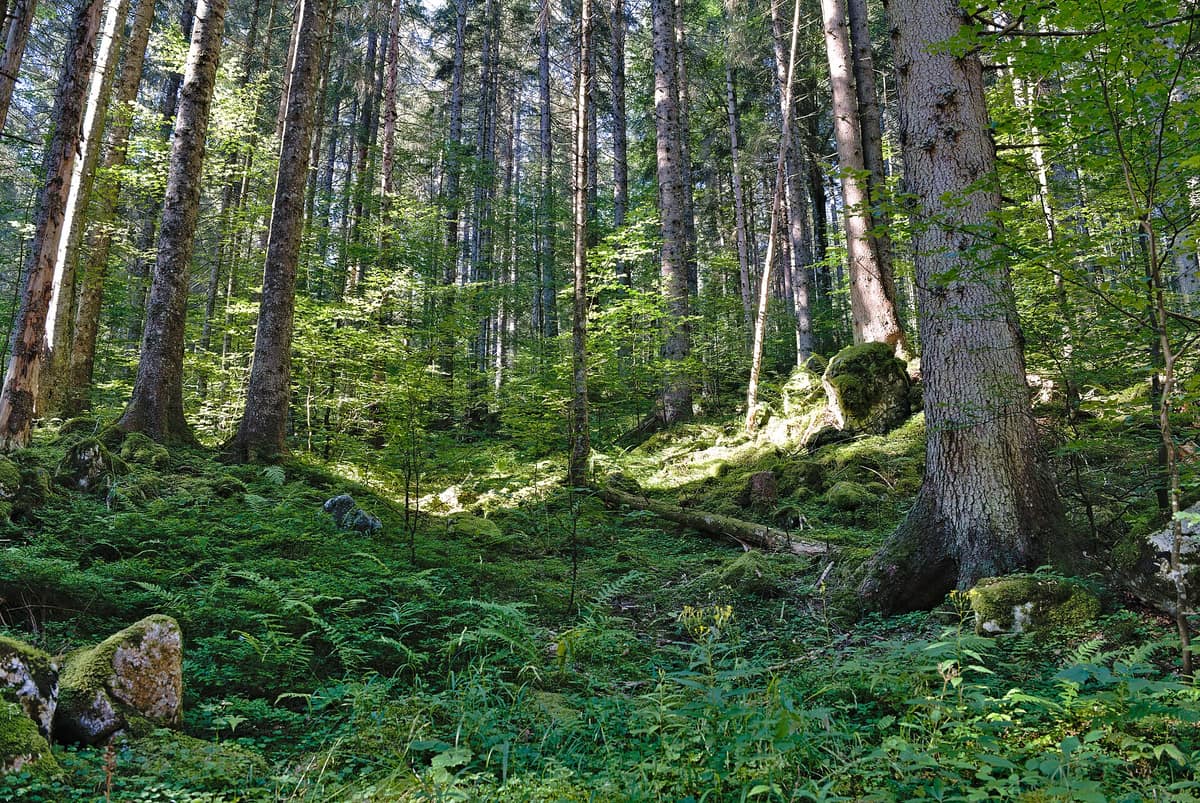
Kalkalpen National Park - Forest Areas
Nationalpark Kalkalpen - Waldgebiete
Upper Austria (Steyr-Land / Kirchdorf) · Austria
Photo: Leonhard Lenz · CC0 · Wikimedia Commons
Austria's largest contiguous tract of broadleaf forest and the grandest wilderness recovery area in the Northern Limestone Alps.
In 1985, grassroots environmentalists occupied the remote Hintergebirge, compelling power companies to scrap proposed hydroelectric dams. That depopulated mountain redoubt is today the heart of Austria's largest forest wilderness. Kalkalpen National Park safeguards some 209 km² across the Sengsengebirge and Reichraminger Hintergebirge, with 16.502 hectares designated as strict «Waldwildnis» (forest wilderness)—an ecological scale unmatched anywhere else in the nation.
What makes it unique
Trees sprout, age, and decay under purely natural dynamics, sheltering old-growth specialist species dependent on standing veteran trees and abundant deadwood.
The place
Nature
The landscape
The park ascends from 385 to 1.963 m across 30 distinct woodland associations. It is equally a realm of water: over 800 pristine springs nourish the longest undisturbed stream system in the Eastern Alps, tumbling through dolomite gorges and mountain torrents in the Reichraminger Hintergebirge.
European beech reigns supreme: the ancient beechwoods of this park alongside those of the Dürrenstein-Lassingtal Wilderness Area were inscribed as Austria's very first UNESCO Natural World Heritage site in 2017. In a primeval relict grove in the Sengsengebirge grows the oldest known European beech in the Alps. The park harbours 32 native tree species—half of all 65 native to Austria—and over 50 shrub species, including snowy mespilus (Amelanchier ovalis), blossoming brightly in spring. Hay meadows and alpine pastures form open islands in a sea of forest, providing refuge for species dependent on sunlit ecotones.
Wildlife and seasons
From the Rosalia longicorn to the Eurasian lynx, the park serves as a primeval sanctuary for endangered species. The golden eagle, Eurasian otter, lynx, and peregrine falcon have returned, joined by breeding black storks. Eight golden eagle territories span the range, alongside 55 mammal species including 17 species of bats. The lynx remains an exceptionally elusive predator, but camera traps consistently confirm resident breeding: it represents Austria's largest wild feline.
The white-backed woodpecker is Austria's rarest woodpecker and the park's foremost avian flagship species, coexisting in remarkable densities with boreal owls and red-breasted flycatchers. Among saproxylic beetles, the Rosalia longicorn finds its most significant Austrian population here, amid 41 confirmed primeval forest relict insect species. Over 1.600 butterfly and moth species have been recorded—the highest diversity of any Austrian protected area.
The seasons guide the wildlife calendar: in spring, rangers lead tours to watch black grouse displaying on lekking grounds or birdwatching expeditions. In mid to late September the deer rut echoes across Bodinggraben, while chamois seek higher crags in the Sengsengebirge. In October the beech canopy turns brilliant golden-orange. The recommended visiting season runs from May to October.
Species
With a page in the atlas
Being mentioned in a source doesn't guarantee sightings: check with the people who manage the area.
Memory and protection
History and conservation
Archaeological finds left by Paleolithic hunters between 18.000 and 10.000 BC were discovered in the Nixloch cave. In later centuries, extensive felling fueled the ironworks of the Eisenwurzen, and the historic logging railway of Reichraming operated until the early seventies.
The national park arose directly from grassroots protests against industrial damming. On 5 December 1996, the Upper Austrian Parliament unanimously passed the National Park Act. Today it holds IUCN Category II status, Ramsar wetland designation, and European Natura network protection, with 89 % dedicated to strict wilderness.
Before you set off
Visiting
How to visit
The park is best explored on foot. The Buchensteig in Reichraming follows an old historic woodsman trail into the Hintergebirge across two legs: 3,5 km to Wilder Graben and 6 km to Große Klause, taking roughly three and a half hours each way. The Weißenbach valley features a two to three-hour loop illustrating the transition from charcoal-burners' forest to commercial timberland and onward to unmanaged wilderness. The hike to Blahbergalm from Weißwasser takes four and a half to five hours, following old bauxite miners' tracks. The stroll through Bodinggraben to Blumaueralm is gentle and barrier-free up to the Jagahäusl.
Mountain bikers enjoy 500 km of waymarked alpine tracks, ranging from the gentle Hintergebirgsradweg to steep hut climbs. The Buchensteig can be combined into a loop returning via the Hintergebirge cycle path, covering eight kilometres of gravel. For wilderness overnight stays, two designated bivouac meadows at Weißwasser and Steyrsteg operate from May to October; registration via the Ennstal visitor centre is required.
The Ennstal visitor centre in Reichraming and the panoramic Wurbauerkogel tower near Windischgarsten present wildlife and geology exhibitions; the tower looks out upon a panoramic vista of 21 peaks exceeding two thousand metres. By night, the park forms part of the Eisenwurzen Dark Sky Reserve, certified by Dark Sky International.
Before you go
There is no strict trail-confinement rule, but visitors are urged to use marked paths; entering sensitive mires and wetlands is prohibited. Rock climbing is permitted only in designated sectors and outside breeding seasons; on the Kampermauer at Hengstpass climbing is closed until 15 July to protect cliff-nesting raptors. Mountain biking is allowed exclusively from 15 April to 31 October, between two hours after sunrise and one hour before sunset. Always review safety alerts and closures before departing.
Check access, rules and visiting conditions in the official information from the managing body before you set off.
Location
Where it is and how far it reaches
Boundary of Nationalpark Kalkalpen · IUCN II · © EEA, CDDA (CC-BY) The coordinate is estimated; it isn't a verified access point.
Transparency
Sources
The research data with its sources, and the official links for this place, are in the Spanish version of this page. See the Spanish version
Around it
Around thirteen kilometres away lies Gesäuse National Park - Enns Gorge, and some twenty-four kilometres away rises the Hochschwab Group. The park also partially overlaps the Totes Gebirge Karst Desert.
What else to explore nearby
Approximate straight-line distance between the edges of each area. It doesn't indicate access, routes or driving times.
- Totes Gebirge - Karst Desert
Upper Austria / Styria (Hinterstoder / Bad Aussee)
About 2 km away
The 'Dead Mountains', Central Europe's largest high-alpine karst desert plateau (over 200 km² of exposed barren limestone void of surface water).
JFMAMJJASONDJune – October · Crowding low
- Gesäuse National Park - Enns Gorge
Styria (Admont / Hieflau)
About 11 km away
Vertical limestone precipices towering over 1.000 m above the thundering whitewater of the Enns river.
JFMAMJJASONDMay – October · Crowding low
- Hochschwab Group
Styria (Aflenz / Mariazell)
About 22 km away
Vast, desert-like karst plateau above 2,000 m hosting the largest concentration of chamois in the Alps.
JFMAMJJASONDJune – October · Crowding low
Entry #115 of the original atlas.