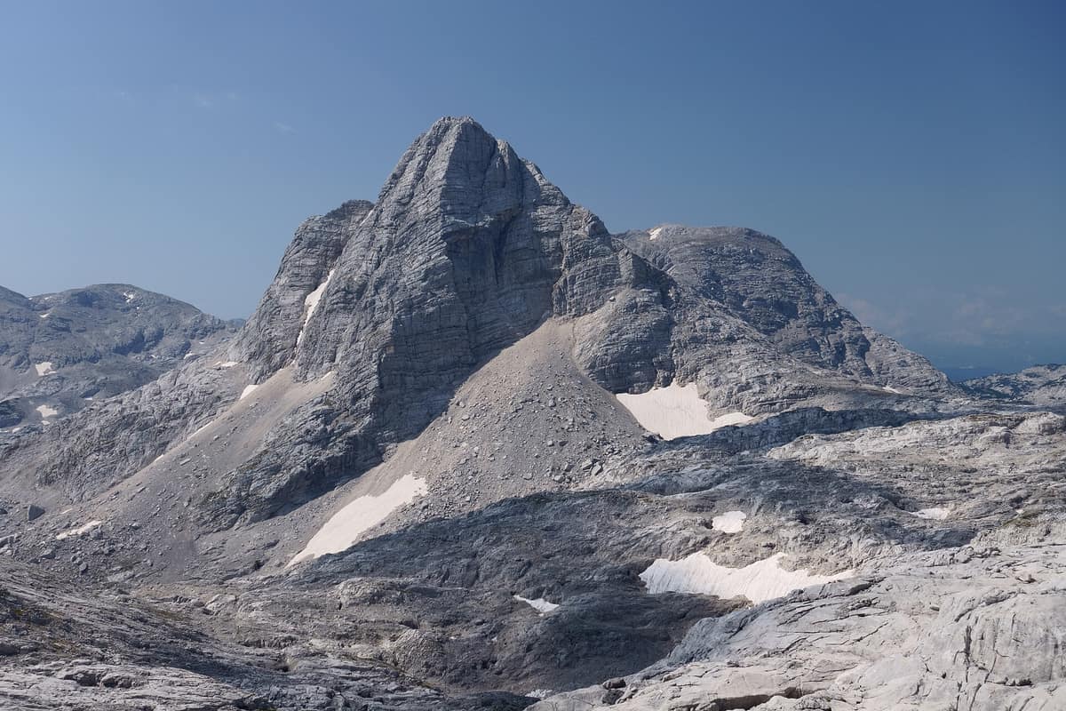
Totes Gebirge - Karst Desert
Upper Austria / Styria (Hinterstoder / Bad Aussee) · Austria
Photo: Tigerente · CC BY-SA 4.0 · Wikimedia Commons
The 'Dead Mountains', Central Europe's largest high-alpine karst desert plateau (over 200 km² of exposed barren limestone void of surface water).
Local mountaineers long ago bestowed an uncompromising name upon this range: «land of bones». In the high interior of the Totes Gebirge, the «dead range», no mountain springs or surface brooks flow and vegetation is sparse, with white ribs of fractured limestone jutting from the plateau like bare skeleton bones. It forms a monumental massif of roughly 1125 km², culminating at the summit of Großer Priel at 2.515 meters, widely regarded as the most expansive limestone karst plateau in Central Europe. Yet descend toward its peripheral fringes and this austere stone desert gives way to sparkling fjord-like lakes, larch forests, summer pastures, and mountain grouse.
What makes it unique
A monumental high-altitude limestone plateau without a single drop of surface water, honeycombed by 2800 known caves beneath, including Austria's longest cavern.
The place
Nature
The landscape
The explanation for its desolate name lies in the geology. The massif consists of heavily karstified Dachsteinkalk limestone, causing nearly all precipitation and snowmelt to drain directly into deep joints and sinkholes, only reappearing as gushing valley springs far below. Consequently, despite annual rainfall ranging between 1200 and over 2500 mm—increasing with altitude—the high plateau remains completely parched. Karst sinkholes are ubiquitous and occasionally gigantic: the Kuhntal doline exceeds 500 meters in diameter.
The karst landscape changes character according to exposure. The eastern and western borders feature a green karst softened by dwarf mountain pine and subalpine pastures, while the central plateau is a grey karst of completely bare rock. Beneath this surface lies an immense speleological labyrinth: the Austrian cave cadastre records some 2800 caverns, most opening on the high plateau. The Schönberg cave system, with 155.018 meters of surveyed passages, represents the longest cave in Austria.
Pleistocene glaciation sculpted the valleys. Glaciers fed by the plateau carved deep basins around the massif that today cradle scenic lakes: Altausseer See and Grundlsee in the southwest; Almsee, Offensee, and Gleinkersee along the northern foot. On the Tauplitzalm plateau lie six mountain lakes. The Traun and Steyr rivers both originate from springs draining the massif.
The peaks divide into three major massifs: the Schönberg group in the west, severed by a major fault from the central Priel group; and the Warscheneck in the east. The three highest summits all rise in the Priel group: the Großer Priel, the Spitzmauer (2.446 m), and the Schermberg (2.396 m).
Wildlife and seasons
Larch woodlands mark the upper timberline, yielding higher up to extensive dwarf mountain pine thickets. Many endemic plant taxa of the northeastern Limestone Alps occur across these crags.
Across the fissured Priel plateau the chamois finds a safe haven and reaches notable population densities. Lower summer pastures support red deer and small numbers of roe deer, alongside mountain hares. Four species of grouse share the massif: rock ptarmigan, black grouse, hazel grouse, and western capercaillie. Alpine choughs and ravens are widespread, and the golden eagle nests across the cliffs. Alpine salamanders and alpine newts sustain healthy populations.
The most extraordinary life forms hide underground: the blind pseudoscorpion Neobisium aueri is endemic exclusively to caverns of this massif, surviving as a Tertiary relict sheltered through the ice ages. Prehistory also left its mark: 7 of the 40 known major bear caves in the Alps are located here, making the range vital for studying extinct cave bears. The modern brown bear, by contrast, has been considered extirpated from the region since 2011.
Species
With a page in the atlas
Being mentioned in a source doesn't guarantee sightings: check with the people who manage the area.
Memory and protection
History and conservation
The earliest alpine refuge, the Loserhütte, opened in 1882 at the eastern edge of the Augstalm at 1.498 meters. Shortly before, in 1878, a young 21-year-old geologist and alpinist, Georg Geyer, published his pioneering monograph «Das Todte Gebirge», laying the foundation for modern alpine geology.
Prehistoric hunters frequented the caves of Salzofenhöhle and Rameschhöhle, leaving behind Mousterian stone artifacts dated between 65.000 and 31.000 BC. In addition, the Feuerkogel fossil locality has yielded nearly 600 Triassic ammonite species, ranking among the world's most significant paleontological sites.
In 1991 Styria established the Totes Gebirge West (154,6 km²) and East (78,17 km²) nature reserves, and in 2006 the European Natura 2000 protected area Totes Gebirge with Altausseer See was formalized. Proposals to interconnect the Hinterstoder ski resort with Wurzeralm across the protected plateau sparked fierce public debate and were ultimately shelved.
Before you set off
Visiting
How to visit
The massif is traversed on foot from mountain hut to hut. Marked trail 201 crosses the range from east to west, reaching its highest point near the Warscheneck as part of the Nordalpenweg, European trail E4, and Via Alpina. This trek connects Spital am Pyhrn, Hinterstoder, the Prielschutzhaus, and the Loserhütte, terminating at Bad Goisern. Since 2020, hikers can also tackle the Welser Höhenweg across the Priel and Schönberg groups, while the Salzsteigweg traverses from Hinterstoder to the Hochmölbinghütte.
Serviced Alpine Club huts ring the perimeter with three located in the interior plateau, complemented by toll roads ascending from Altaussee (Loser-Panoramastraße), Bad Mitterndorf (Tauplitz), and Hinterstoder.
Before you go
This is a challenging massif characterized by long distances and a total absence of surface water on the plateau. Plan daily stages strictly between staffed huts and carry ample fluids, as no springs exist above the valleys.
Check access, rules and visiting conditions in the official information from the managing body before you set off.
Location
Where it is and how far it reaches
Boundary of Totes Gebirge · © OpenStreetMap contributors (ODbL) The coordinate is estimated; it isn't a verified access point.
Transparency
Sources
The research data with its sources, and the official links for this place, are in the Spanish version of this page. See the Spanish version
Around it
About 4 km to the west lies the Dachstein Nature Reserve - Gosau, Hallstatt and Obertraun, and 16 km to the east sits Gesäuse National Park - Enns Gorge. Farther west, the Steinernes Meer - Sea of Stone shares alpine karst desert terrain, chamois, and rock ptarmigan.
What else to explore nearby
Approximate straight-line distance between the edges of each area. It doesn't indicate access, routes or driving times.
- Kalkalpen National Park - Forest Areas
Upper Austria (Steyr-Land / Kirchdorf)
About 2 km away
Austria's largest contiguous tract of broadleaf forest and the grandest wilderness recovery area in the Northern Limestone Alps.
JFMAMJJASONDMay – October · Crowding low
- Dachstein Nature Reserve — Gosau, Hallstatt and Obertraun
Upper Austria — Gmunden; Gosau, Hallstatt and Obertraun
About 6 km away
Karst topography, glaciers, alpine meadows and old-growth mountain forests above the Gosau lakes.
JFMAMJJASONDMarch – November · Crowding no data
- Gesäuse National Park - Enns Gorge
Styria (Admont / Hieflau)
About 20 km away
Vertical limestone precipices towering over 1.000 m above the thundering whitewater of the Enns river.
JFMAMJJASONDMay – October · Crowding low
- Tennengebirge Karst Plateau
Salzburg (Werfen / Abtenau)
About 25 km away
Alpine limestone plateau rimmed by precipitous escarpments housing Eisriesenwelt, the largest explored ice cave on Earth (42 km of surveyed passages).
JFMAMJJASONDJune – October · Crowding low
If you like this place, elsewhere in Europe
Distant places with uncommon wildlife and habitats in common. The most widespread species don't count. Sharing species doesn't imply a corridor or guaranteed presence.
- Monviso Natural Park
Piedmont — Po and Varaita Valleys (Province of Cuneo)
In common: Lyrurus tetrix · Lepus timidus · Rock ptarmigan — high mountain
Alpine pastures and rocky crags between the Po and Varaita valleys, harbouring the ancient stone pine forest of Alevè.
JFMAMJJASONDJuly – September · Crowding high
- Aigüestortes and Lake Saint Maurici National Park
Catalonia (Lleida)
In common: Pyrrhocorax graculus · Rock ptarmigan · Western capercaillie — high mountain, lake
The only National Park in Catalonia, a glacial circus wonderland harboring over 200 tarns (estanys) beneath the iconic twin summits of Els Encantats.
JFMAMJJASONDJune – October · Crowding moderate
- Retezat National Park
Hunedoara County (Hațeg)
In common: Ichthyosaura alpestris · Western capercaillie · Chamois — high mountain
The realm of the granitic and glacial Retezat, with over 80 crystal tarns and the Gemenele scientific reserve.
JFMAMJJASONDJune – October · Crowding low
Entry #347 of the original atlas.