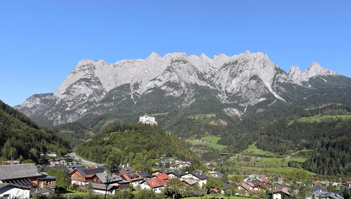
Tennengebirge Karst Plateau
Tennengebirge - Karst Plateau
Salzburg (Werfen / Abtenau) · Austria
Photo: C.Stadler/Bwag · CC BY-SA 4.0 · Wikimedia Commons
Alpine limestone plateau rimmed by precipitous escarpments housing Eisriesenwelt, the largest explored ice cave on Earth (42 km of surveyed passages).
High upon the Tennengebirge rain falls copiously yet not a single brook flows across the surface. Rainwater and snowmelt instantly vanish into deep fissures and sinkholes, plunging into the mountain's core where subterranean waters have hollowed out cavern systems over millions of years. This prominent massif of the Northern Limestone Alps in Salzburg forms a severely karstified Dachsteinkalk limestone plateau spanning some 280 km², culminating at Raucheck at 2.430 meters. From outside it appears as sheer barren limestone; within, it is honeycombed with more than a thousand cataloged caves, including the grandest ice cave system on the planet.
What makes it unique
Beneath a riverless plateau slumbers Eisriesenwelt, 42 kilometers of caverns of which only the first is cloaked in ice.
The place
Nature
The landscape
Envision a gigantic stone sponge. The heavily fractured Dachsteinkalk limestone allows precipitation to drain directly underground, leaving the plateau void of permanent surface streams. Infiltrating water converges in vast subterranean drainage networks; beneath the limestone lie impermeable basement strata dipping northwards, forcing underground aquifers to discharge through abundant karst resurgences along the northern base of the range.
The caves also preserve the morphotectonic evolution of the Alps. Passages are arranged in stepped horizontal tiers corresponding to past water table elevations. The giant cave horizon housing Eisriesenwelt formed during the Late Miocene. Most cave entrances sit between 1.500 and 1.600 meters in altitude, with Austrian speleological registries listing more than a thousand caves across the massif.
Eisriesenwelt behaves counterintuitively: its ice mass grows primarily during winter. Cold winter drafts enter through a chimney effect, penetrating nearly a kilometer into the mountain; the frigid rock retains this subzero chill into spring, freezing incoming surface meltwater into magnificent stalagmites and ice walls. Consequently, only the first kilometer forms an ice palace, while the remainder is dry limestone gallery.
Roughly 37 km² of the plateau lie above 2.000 meters. To the west, the Salzach river separates it from the Hagengebirge in the Berchtesgaden Alps.
Wildlife and seasons
Much of the plateau's specialized fauna dwells beneath ground. The nature reserve shelters the lesser horseshoe bat, an endangered troglophile mammal, alongside greater mouse-eared and Bechstein's bats. Avifauna recorded across the Northern Limestone Alps includes the golden eagle, Eurasian sparrowhawk, northern goshawk, Eurasian eagle-owl, hazel grouse, and white-throated dipper.
The seasons are dictated by snow and ice. The cave generally welcomes visitors from 1 May to 26 October; in winter the entrance remains completely inaccessible due to high altitude and severe avalanche hazard. On the plateau, winter attracts experienced ski mountaineers undertaking wilderness traverses.
Species
With a page in the atlas
Being mentioned in a source doesn't guarantee sightings: check with the people who manage the area.
Memory and protection
History and conservation
The massif takes its name from the Tennalm, an alpine pasture on the eastern rim of the plateau. The cave itself possesses a colorful folklore history. Local peasants had long known the dark maw, believing it to be the entrance to hell and avoiding it. In 1879 Salzburg naturalist Anton Posselt penetrated roughly 200 meters into the darkness. Speleologist Alexander von Mörk, killed in World War I in 1914, rests in an urn within the cave cathedral bearing his name. Guided public tours commenced in 1920, and in 1955 the aerial cable car reduced a arduous hour-and-a-half climb to just three minutes. Admission fees help fund ongoing exploration and scientific monitoring.
The entire rocky high plateau is designated a nature reserve covering 8541,7 hectares, protecting alpine karst landforms, limestone grasslands, and montane ecosystems. The southern foothills form a landscape protection buffer encompassing 4781,3 hectares.
Before you set off
Visiting
How to visit
The premier highlight is the Eisriesenwelt. From the visitor parking area a foot trail leads to the cable car station, which ascends to the cave portal; in clear weather, panoramic vistas unfold across the Salzach valley toward the Hohe Tauern. The guided cave tour lasts one hour and a quarter, traversing a kilometer of ice formations; plan around three hours for the complete excursion. The tour involves ascending some 1.400 wooden steps in temperatures hovering around zero degrees Celsius: warm winter clothing, gloves, and sturdy footwear are essential. Photography and filming are prohibited inside the cave, and drone use is restricted across the mountain.
For trekkers, the massif offers classic multi-day plateau traverses. European long-distance trail E4, coinciding here with the Via Alpina, traverses the southern flanks from Lungötz to Werfen via the Söldenhütte, while the Salzburger Arnoweg traverses the west from Annaberg to the Laufener Hütte and onwards to Abtenau. Numerous Alpine Club huts provide accommodation, but expeditions require alpine experience, sure-footedness, and awareness of the complete lack of surface water and severe fog disorientation risks.
Active valley resurgence caves include the Brunneckerhöhle at Pass Lueg, Winnerfall, and Tricklhöhle: all subject to violent seasonal flooding during spring snowmelt.
Before you go
The ice cave tour requires a half-day excursion and does not operate in winter. When venturing onto the high plateau, carry all drinking water with you: the karst terrain provides no springs. Mountain huts are plentiful, but alpine self-reliance and weather vigilance remain your responsibility.
Check access, rules and visiting conditions in the official information from the managing body before you set off.
Location
Where it is and how far it reaches
Boundary of Tennengebirge · IUCN V · © EEA, CDDA (CC-BY) The coordinate is estimated; it isn't a verified access point.
Transparency
Sources
The research data with its sources, and the official links for this place, are in the Spanish version of this page. See the Spanish version
Around it
About 8 km away lies the Dachstein Nature Reserve - Gosau, Hallstatt and Obertraun, and 10 km across the Salzach valley stands Berchtesgaden National Park - Hagengebirge Massif. Roughly 20 km to the west lies the Steinernes Meer - Sea of Stone and 26 km to the south the Ankogel Group - Hohe Tauern.
What else to explore nearby
Approximate straight-line distance between the edges of each area. It doesn't indicate access, routes or driving times.
- Dachstein Nature Reserve — Gosau, Hallstatt and Obertraun
Upper Austria — Gmunden; Gosau, Hallstatt and Obertraun
About 8 km away
Karst topography, glaciers, alpine meadows and old-growth mountain forests above the Gosau lakes.
JFMAMJJASONDMarch – November · Crowding no data
- Berchtesgaden National Park - Hagengebirge Massif
Bavaria (Berchtesgaden) (DE) / Salzburg (AT)
About 10 km away
Germany's only high-alpine National Park, dominated by mount Watzmann (2.713 m) and the fjord-like Königssee.
JFMAMJJASONDJune – October · Crowding moderate
- Steinernes Meer - Sea of Stone
Bavaria (DE) / Salzburg (Saalfelden / Maria Alm) (AT)
About 11 km away
The 'Sea of Stone', a vast undulating desert-like limestone plateau suspended at 2.000 m altitude straddling Germany and Austria.
JFMAMJJASONDJune – October · Crowding low
- Ankogel Group - Hohe Tauern
Carinthia / Salzburg (Mallnitz / Bad Gastein)
About 18 km away
The 'Gateway to the Tauern', crystalline massif of the Ankogel (3,252 m) with retreating glaciers and pristine alpine alluvial valleys.
JFMAMJJASONDJune – October · Crowding low
- Totes Gebirge - Karst Desert
Upper Austria / Styria (Hinterstoder / Bad Aussee)
About 25 km away
The 'Dead Mountains', Central Europe's largest high-alpine karst desert plateau (over 200 km² of exposed barren limestone void of surface water).
JFMAMJJASONDJune – October · Crowding low
Entry #348 of the original atlas.