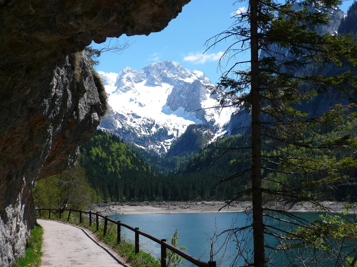
Dachstein Nature Reserve — Gosau, Hallstatt and Obertraun
Naturschutzgebiet Dachstein in den Gemeinden Gosau, Hallstatt und Obertraun
Upper Austria — Gmunden; Gosau, Hallstatt and Obertraun · Austria
Photo: Pauljaeg · CC BY-SA 4.0 · Wikimedia Commons
Karst topography, glaciers, alpine meadows and old-growth mountain forests above the Gosau lakes.
The Dachstein possesses glaciers and deep mountain lakes that appear to have no surface feeder streams. Beneath the fractured limestone, snow and ice meltwaters filter into abyss-like sinkholes and caves, resurfacing at the foot of the massif: filling the Gosau lakes from submerged sub-lacustrine springs fed by glacial melt, or swelling the Kessel near Hallstatt, which surges only after extreme deluges. The Dachstein nature reserve, straddling the municipalities of Gosau, Hallstatt and Obertraun, encompasses the highest limestone bastion of Upper Austria, holding the federal state’s sole glaciers and cascading from high alpine meadows down into the ravine forests of Koppenwinkel.
What makes it unique
Upper Austria’s only glacier realm, resting on a vast limestone massif that swallows its waters underground to return them through hidden springs and tarns.
The place
Nature
The landscape
The Dachstein forms a colossal limestone massif crowned by elevated plateaux and sheer jagged ridges like the Gosaukamm. It consists primarily of heavily karstified Dachstein limestone, harbouring the most extensive glacier zone in the Northern Limestone Alps. Its barren tablelands feature giant dolines and expansive karren lapiaz fields, underlain by profound cave labyrinths: the Hirlatzhöhle, exceeding 112 km in surveyed passages, is the third longest cave system in Austria, while the Mammuthöhle, Rieseneishöhle and Koppenbrüllerhöhle operate as show caves open to the public.
The imprint of the ice ages is etched across every landform. The Dachstein cradles the easternmost glacier in the Alps, shrinking noticeably yet retaining its status as the largest single ice body in the Northern Limestone Alps; the primary three are the Hallstätter Gletscher, Großer Gosaugletscher and Schladminger Gletscher. Both Lake Hallstatt and Hinterer Gosausee occupy deep bedrock troughs excavated by Pleistocene glaciers. The Gosau lake valley is a dramatic tectonic graben separating bedded Dachstein lagoonal limestone from the fossil reef limestone of the Gosaukamm.
Vegetation ascends in distinct altitudinal zones. Lower slopes support mixed spruce, silver fir and European beech; near 1800 m grow hardy stands of Swiss stone pine marking the timberline. Dwarf mountain pine forms a dense creeping scrub belt reaching up to roughly 2000 m before giving way to alpine heath and turf. Above the tree line stretches a near-pristine wilderness of krummholz pine, alpine tundra, rock screes and precipitous cliffs. In the Koppenwinkel, specialized ravine forests and grey alder woodlands flank cold karst seepages.
Wildlife and seasons
The arid high-altitude plateau offers prime sanctuary for the chamois, which maintains high population densities, and shelters Upper Austria’s only resident herd of alpine ibex. Near Bachlalm several colonies of alpine marmot thrive, all descending from historical reintroductions, alongside the mountain hare.
In the alpine air, alpine choughs and common ravens are daily sights. Four distinct grouse species inhabit the massif: rock ptarmigan, black grouse, hazel grouse and capercaillie. The alpine accentor and white-winged snowfinch have been regularly recorded, and the golden eagle maintains established breeding territories across the crags.
Memory and protection
History and conservation
The Dachstein massif and inner Salzkammergut were inscribed on the UNESCO World Heritage list in December 1997 as the Hallstatt–Dachstein/Salzkammergut Cultural Landscape, shaped by Hallstatt’s prehistoric salt mining heritage. The modern nature reserve was legally established under an Upper Austrian provincial government ordinance in 2018, officially proclaiming the Dachstein within Gosau, Hallstatt and Obertraun. The red Hallstätter Kalk limestone is also internationally famed for its Triassic ammonites, constituting one of the most celebrated paleontological deposits in the world.
Before you set off
Visiting
How to visit
The natural approach is through Obertraun. From Gasthaus Koppenrast, an unpaved forest track leads directly into the Koppenwinkel reserve; after roughly 20 minutes you reach Koppenwinkelsee, a transparent shallow lake fed exclusively by groundwater springs. The Koppenwinkel circuit is ideal for families: entirely flat, requiring around two hours of gentle walking.
The Dachsteinhöhlenpfad climbs toward the cable car base station, the launch point for the Rieseneishöhle ice cave and Mammuthöhle. The Obertrauner Höhenweg, a level panoramic trail lined with benches, traces the flanks of the Sarstein 50 to 80 metres above the valley floor. And the Salzkammerweg completes a 45,5 km circuit around the Hoher Sarstein in five stages, connecting Ausseerland with the inner Salzkammergut.
The Kessel near Hallstatt is a periodic karst siphon spring that erupts only during exceptional torrential rains or violent spring snowmelt, protected as a natural monument. To the west, the reserve embraces the magnificent Gosau lakes.
Before you go
Reserve regulations permit hiking on foot across the territory. Strict municipal dog-leash rules apply on the path through Koppenwinkel up to Ebnersteg. The glaciers are undergoing rapid retreat, so do not expect the ice extent seen in historical photographs. Check local advisories and trail closures with Obertraun municipal office prior to setting out.
Check access, rules and visiting conditions in the official information from the managing body before you set off.
Location
Where it is and how far it reaches
Boundary of Naturschutzgebiet Dachstein in den Gemeinden Gosau, Hallstatt und Obertraun · IUCN IV · © EEA, CDDA (CC-BY) The coordinate is estimated; it isn't a verified access point.
Transparency
Sources
The research data with its sources, and the official links for this place, are in the Spanish version of this page. See the Spanish version
Around it
Roughly 6 km away lies the Totes Gebirge, another vast karst desert, and about 8 km away rises the Tennengebirge Karst Plateau.
What else to explore nearby
Approximate straight-line distance between the edges of each area. It doesn't indicate access, routes or driving times.
- Totes Gebirge - Karst Desert
Upper Austria / Styria (Hinterstoder / Bad Aussee)
About 6 km away
The 'Dead Mountains', Central Europe's largest high-alpine karst desert plateau (over 200 km² of exposed barren limestone void of surface water).
JFMAMJJASONDJune – October · Crowding low
- Tennengebirge Karst Plateau
Salzburg (Werfen / Abtenau)
About 8 km away
Alpine limestone plateau rimmed by precipitous escarpments housing Eisriesenwelt, the largest explored ice cave on Earth (42 km of surveyed passages).
JFMAMJJASONDJune – October · Crowding low
If you like this place, elsewhere in Europe
Distant places with uncommon wildlife and habitats in common. The most widespread species don't count. Sharing species doesn't imply a corridor or guaranteed presence.
- Aigüestortes and Lake Saint Maurici National Park
Catalonia (Lleida)
In common: Alpine accentor · Rock ptarmigan · Alpine marmot — high mountain, old-growth forest, lake
The only National Park in Catalonia, a glacial circus wonderland harboring over 200 tarns (estanys) beneath the iconic twin summits of Els Encantats.
JFMAMJJASONDJune – October · Crowding moderate
- Gran Paradiso National Park
Aosta Valley / Piedmont (Cogne / Valsavarenche / Ceresole Reale)
In common: Rock ptarmigan · Alpine marmot · Alpine ibex — high mountain, old-growth forest
Italy's oldest national park (1922): the last surviving Alpine ibex population held out here and repopulated the entire range.
JFMAMJJASONDJune – September · December – January · Crowding moderate
- Vanoise National Park
Auvergne-Rhône-Alpes (Savoie)
In common: Rock ptarmigan · Alpine marmot · Alpine ibex — high mountain
France's first national park (1963), created to save the Alpine ibex: glaciers, alpine grasslands, and one of the Alps' greatest ibex populations.
JFMAMJJASONDJune – September · Crowding moderate
- Maritime Alps Natural Park
Piedmont (Cuneo / Valdieri / Entracque)
In common: Alpine marmot · Alpine ibex · Chamois — high mountain, old-growth forest
United with France's Mercantour National Park, it forms a massive cross-border Alpine-Mediterranean wilderness crowned by Mount Argentera (3.297 m).
JFMAMJJASONDJune – October · Crowding low
Entry #1066 of the original atlas.