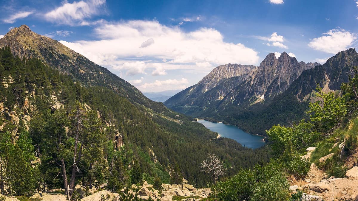
Aigüestortes and Lake Saint Maurici National Park
Parc Nacional d'Aigüestortes i Estany de Sant Maurici
Catalonia (Lleida) · Spain
Photo: Jolaus · CC0 · Wikimedia Commons
The only National Park in Catalonia, a glacial circus wonderland harboring over 200 tarns (estanys) beneath the iconic twin summits of Els Encantats.
Glaciers gouged out the valleys of this Pyrenean sector, leaving the rugged landscape you traverse today: sharp horns, jagged ridgelines, sweeping amphitheatres at valley heads, and rock-carved tarns. Aigüestortes and Estany de Sant Maurici National Park preserves countless alpine lakes, 300-million-year-old granite batholiths, and a wide meadowed plain where a river meanders freely among peat bogs, lush meadows, and mountain pines.
What makes it unique
Within a single high-mountain sanctum coexist glacial tarns, the jagged peaks of Els Encantats beside Lake Sant Maurici, and a braided alluvial plain—Aigüestortes—that was once a lake and gave the park its name.
The place
Nature
The landscape
Begin with the stone. The core of the park is a massive granite pluton around 300 million years old that surfaced through tectonic uplift and continuous erosion; metamorphic slates and limestones frame the outer edges. It is from these metamorphic limestones that Els Encantats—the park's most emblematic twin peaks—are carved.
Then came the glaciers. They scooped out deep cirques with near-vertical amphitheatre walls, most notably Amitges with its famous granite needles, and Colomèrs, one of the largest in the range. Alpine tarns occupy different tiers within this topography: most lie nested at the base of high cirques and plunge to the greatest depths, while Sant Maurici and Estany Llong occupy lower valley floors.
The plain of Aigüestortes tells its own story. It was once a large glacial lake that river sediments and mountain torrents gradually filled completely. Today the river of Sant Nicolau meanders lazily across it between wetlands, boggy lawns, and mountain pines, where wooden boardwalks allow you to explore even in a wheelchair.
Elevation orchestrates everything. Between lower elevations at 1200 m and the highest peak at 3029 m, vegetation belts succeed one another with precision. In the montane belt up to roughly 1800 m grow deciduous woodlands of downy oak and beech, frequently replaced by Scots pine forests. Silver firs favor sheltered north-facing slopes, rarely rising above 2000 m; above them, mountain pine forms open subalpine forests carpeted with rhododendron and bilberry. Higher still stretch alpine meadows speckled with alpine gentian, Pyrenean buttercup, and moss campion. In lakes, springs, and peat bogs thrive water-crowfoot, delicate wild orchids, and a small carnivorous plant, the round-leaved sundew. Bordering the park to the north of Pallars Sobirà lies the expansive fir forest of Mata de València.
Wildlife and seasons
Some 200 vertebrate species inhabit the park, though spotting them requires keen patience. Notable mammals include the Pyrenean chamois, wild boar, ermine, Alpine marmot, and roe deer.
Birds are the most diverse group. Deep in inaccessible forests dwell the black woodpecker, western capercaillie, boreal owl, and red crossbill. Soaring above scree slopes and barren ridges are the griffon vulture, golden eagle, and bearded vulture. Across alpine grasslands you can encounter the rock ptarmigan, Alpine accentor, white-winged snowfinch, and yellow-billed chough.
Cold mountain waters hold rare gems: the Pyrenean brook salamander is an endemic amphibian of clean torrents, while sea trout thrives in the pristine, icy currents. Among reptiles, look out for the asp viper and smooth snake; the former is venomous.
The mountain calendar dictates access. From late November through early May nearly the entire park lies buried under deep snow, demanding winter mountaineering gear and thorough avalanche knowledge. Snowshoeing and ski mountaineering are popular winter pursuits. For foot hiking, the main season runs from June to October.
Species
With a page in the atlas
Being mentioned in a source doesn't guarantee sightings: check with the people who manage the area.
Memory and protection
History and conservation
The area was declared a national park on 21 October 1955 encompassing 9851 ha, becoming Spain's fifth national park and the second in the Pyrenees after Ordesa. The inner national park core spans 14.119 hectares today, wrapped by a peripheral buffer zone providing graduated protection.
Hydroelectric development in the Pyrenees during the first half of the twentieth century profoundly reshaped the landscape; water harnessing remains an integral part of local history alongside traditional pastoral livestock grazing. In the Vall de Boí, the cluster of Catalan Romanesque churches, including Sant Climent and Santa Maria de Taüll, was declared a UNESCO World Heritage Site on 30 November 2000.
Before you set off
Visiting
How to visit
The two traditional gateways are Boí and Espot. Boí provides access to the Aigüestortes plain; Espot leads to Lake Sant Maurici. Driving between them takes around two hours along winding mountain roads, so your first task is choosing which valley to explore. Access on foot is free; bicycles are only permitted as far as the information checkpoints at Sant Maurici and Aigüestortes. Authorized public shuttle taxi services operate from Espot and Boí up to Lake Sant Maurici and the Aigüestortes plain, respectively.
Begin your trip at the Park House in Boí or Espot. Open year-round, they feature permanent exhibits (Espot interprets the park's three pillars: rock, water, and life) and provide trail leaflets for the best itineraries in each valley, designed for half-day or full-day excursions. In Llessui you will find the Shepherd Ecomuseum of the Vall d'Àssua; in Senet, an exhibit exploring human-wildlife relationships; and at the top station of the Lake Gento cable car, open in summer, an information hut offering guided outings and an exhibit on hydropower.
From Boí, wooden boardwalks allow you to walk among the braided meanders of Aigüestortes, with an accessible adapted section right across the meadow. On the Espot side, the trail from Prat de Pierró car park up to Lake Sant Maurici takes 1 h 15 min and climbs 260 m. From the lake, a loop via the Ratera waterfall, its upper tarn, and the Sant Maurici viewpoint takes 2 h 30 min with 300 m of ascent. Hiking up to the Needles of Amitges is another classic extension. The GR 11 trans-Pyrenean route crosses the park from east to west.
For trekkers with several days, Camins vius circles the perimeter connecting historic villages along ancient mule tracks. The famous Carros de Foc connects staffed mountain huts in a high-altitude circuit: completing it on foot requires at least four days.
Before you go
Hunting, fishing, capturing wildlife, and lighting open fires are strictly prohibited within the park. Swimming and water sports in rivers, tarns, and streams are forbidden, and you must remain on designated trails. Carry alpine equipment: mountain weather changes abruptly. In an emergency, all mountain huts are equipped with emergency radio links to the Catalan Fire and Rescue Service. In winter, always check road and trail conditions with one of the two Park Houses before setting out.
Check access, rules and visiting conditions in the official information from the managing body before you set off.
Location
Where it is and how far it reaches
Boundary of Aigüestortes i Estany de Sant Maurici · IUCN II · © EEA, CDDA (CC-BY) The coordinate is estimated; it isn't a verified access point.
Transparency
Sources
The research data with its sources, and the official links for this place, are in the Spanish version of this page. See the Spanish version
Around it
Farther afield, other high-mountain national parks share glacial landscapes and Pyrenean wildlife: the Pyrénées National Park, with Pyrenean chamois and marmots, and the Gran Paradiso National Park, with marmots and bearded vultures.
If you like this place, elsewhere in Europe
Distant places with uncommon wildlife and habitats in common. The most widespread species don't count. Sharing species doesn't imply a corridor or guaranteed presence.
- Maritime Alps Natural Park
Piedmont (Cuneo / Valdieri / Entracque)
In common: Pyrrhocorax graculus · Alpine marmot · Bearded vulture — high mountain, glacial landscape, old-growth forest
United with France's Mercantour National Park, it forms a massive cross-border Alpine-Mediterranean wilderness crowned by Mount Argentera (3.297 m).
JFMAMJJASONDJune – October · Crowding low
- Gran Paradiso National Park
Aosta Valley / Piedmont (Cogne / Valsavarenche / Ceresole Reale)
In common: Vipera aspis · Rock ptarmigan · Alpine marmot — high mountain, glacial landscape, old-growth forest
Italy's oldest national park (1922): the last surviving Alpine ibex population held out here and repopulated the entire range.
JFMAMJJASONDJune – September · December – January · Crowding moderate
- Dachstein Nature Reserve — Gosau, Hallstatt and Obertraun
Upper Austria — Gmunden; Gosau, Hallstatt and Obertraun
In common: Alpine accentor · Rock ptarmigan · Alpine marmot — high mountain, lake, old-growth forest
Karst topography, glaciers, alpine meadows and old-growth mountain forests above the Gosau lakes.
JFMAMJJASONDMarch – November · Crowding no data
Entry #491 of the original atlas.