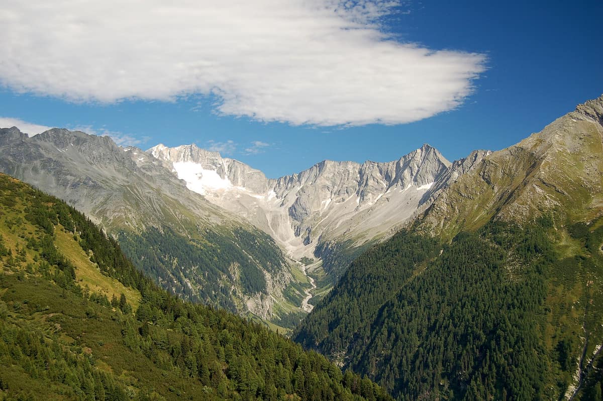
Ankogel Group - Hohe Tauern
Ankogelgruppe - Hohe Tauern
Carinthia / Salzburg (Mallnitz / Bad Gastein) · Austria
Photo: Herzi Pinki · CC BY-SA 3.0 · Wikimedia Commons
The 'Gateway to the Tauern', crystalline massif of the Ankogel (3,252 m) with retreating glaciers and pristine alpine alluvial valleys.
Some valleys came dangerously close to disappearing beneath reservoirs. The Seebachtal, at 1,270 m altitude and framed by steep alpine peaks, was nearly dammed for hydroelectricity in the nineteen-seventies. It was saved, and today an interpretive nature trail wanders its floor between mountain forests, alpine meadows, and braided meanders. It serves as the main gateway to the Ankogel Group, the eastern bastion of the Hohe Tauern across Salzburg and Carinthia, nestled within the largest national park in the Alps.
What makes it unique
Here, in a single afternoon, you can stroll beside a turquoise river of white sand and feel a freezing draught rushing from deep within the rocks.
The place
Nature
The landscape
The Ankogel gives its name to the massif and reaches 3,252 m, though the crowning summit of the range is the Hochalmspitze at 3,360 m. The group spans the Ankogel, Hochalmspitze, Hafner, and Reißeck massifs, and encompasses the Maltatal—the 'valley of tumbling waters'—famous for the Fallbach waterfall and the towering Kölnbrein Dam. Along the valley floor runs the Malteiner Wasserspiele water path, tracing deep gorges and roaring cascades.
Geology explains why these mountains rise so high. The group lies within the 160-km-long Tauern Window, where geological layers that elsewhere lie buried deep beneath the Alps were thrust up to the surface. Four major granite-gneiss domes, formed from ancient molten magma, form the core of this tectonic window and sculpted summits such as the Grossvenediger. Subsequent glaciations carved out cirques and valleys, with ice and water continuing their erosive work today. The national park protects 332 glaciers, covering nearly six percent of its surface area, which are in rapid retreat under a warming climate.
Subalpine forests climb to between 2,000 and 2,200 m—roughly 200 to 300 m below their climatic potential—because centuries of grazing and timber harvesting pushed the tree line downward. Above thrive rusty-leaved alpenrose blooming in May and early June, edelweiss, and Rudolph's saxifrage, a high-alpine endemic of the Hohe Tauern clinging to limestone screes and rocky ledges. In total, around 3,500 plant species have been documented across the national park, many protected for their regional rarity.
Wildlife and seasons
The golden eagle adorns the national park emblem, with roughly 40 breeding pairs established in the territory. The bearded vulture was reintroduced in 1986 and achieves a wingspan of up to 2.9 m. The griffon vulture makes its sole, seasonal summer guest appearance here within the Alpine arc. In the Seebachtal, the alpine swift and crag martin are among the many nesting birds.
Among mammals, the chamois is most readily seen across high ridges. The Alpine ibex populates crags and screes, numbering around 1,100 animals following successful reintroductions in the nineteen-sixties. Alpine marmots live in family colonies between 1,400 and 2,700 m, whistling shrill warnings: a single whistle for an aerial predator, a rhythmic series for terrestrial threats. Brown bears and wolves are now memories here, having vanished during the nineteenth century.
In winter, avalanche danger is a constant factor in planning. The optimal hiking season spans June through October.
Species
With a page in the atlas
Being mentioned in a source doesn't guarantee sightings: check with the people who manage the area.
Memory and protection
History and conservation
The national park grew out of a tripartite treaty: in 1971 the provincial governors of Salzburg, Carinthia, and Tyrol met at Heiligenblut to pledge the creation of an alpine national park. Enabling legislation was enacted in Carinthia in 1981, Salzburg in 1984, and Tyrol in 1992. The IUCN granted Category II status in 2001 for Carinthia and in 2006 for Salzburg and Tyrol. Covering 1,856 km², it is the largest national park in the Alps and contains the largest continuous Natura 2000 site in Austria.
In the core wilderness zone strict process protection applies, precluding economic uses across 75% of the perimeter. Two historic Roman roads once crossed high passes over the Mallnitz and Korn Tauern.
Before you set off
Visiting
How to visit
The ideal introductory hike is the Seebachtal nature trail: an easy, seven-kilometre circuit setting out from the Ankogelbahn car park and reaching Lake Stappitzer See. Midway, a path branches right to the Seebach river, showcasing turquoise water and banks of white glacial sand. A covered observation tower stands beside interpretive lake boards, while farther along the trail traverses mountain forest, alpine pastures, and braided stream gravels leading onto an alluvial fan. The final two stops are the 'praying forest' and the 'ice hole', where subterranean fissures vent freezing air.
To understand the high-alpine environment before setting out, the BIOS National Park Centre in Mallnitz provides interactive displays and wildlife updates through its 'univerzoom nationalpark' exhibition. Park rangers offer specialized wildlife viewing excursions, including dawn wildlife-watching tours.
Mallnitz is reachable by road. From Salzburg, motorists reaching Badgastein-Böckstein can load their vehicles onto the Tauern motorail shuttle train directly to Mallnitz; regional buses also serve the village.
Before you go
Trails are marked with yellow signposts and red or black difficulty dots; black dots indicate demanding alpine routes requiring sure-footedness and alpine experience. Camping and lighting fires in open terrain are strictly forbidden. Stay on marked paths and avoid unnecessary noise.
Check access, rules and visiting conditions in the official information from the managing body before you set off.
Location
Where it is and how far it reaches
Boundary of Ankogelgruppe · © OpenStreetMap contributors (ODbL) The coordinate is estimated; it isn't a verified access point.
Transparency
Sources
The research data with its sources, and the official links for this place, are in the Spanish version of this page. See the Spanish version
Around it
Directly adjoining the Ankogel within the same national park lies Hohe Tauern National Park - Umbal Valley and Isel River Headwaters. About six kilometres away lies Schober Group - Hohe Tauern, and roughly twenty-four kilometres away lies Tarvisio Forest and Italian Julian Alps. Distant alpine protected areas sharing ibex and chamois in glaciated landscapes include Vanoise National Park, Stelvio National Park, and Maritime Alps Natural Park.
What else to explore nearby
Approximate straight-line distance between the edges of each area. It doesn't indicate access, routes or driving times.
- Hohe Tauern National Park - Umbal Valley and Isel Headwaters
East Tyrol / Carinthia / Salzburg (Matrei in Osttirol / Prägraten)
Borders this area
The largest National Park in the Alps and Central Europe (1.800 km²), sheltering the Grossglockner (3.798 m) and the wild Isel glacial river.
JFMAMJJASONDJune – October · Crowding low
- Steinernes Meer - Sea of Stone
Bavaria (DE) / Salzburg (Saalfelden / Maria Alm) (AT)
About 17 km away
The 'Sea of Stone', a vast undulating desert-like limestone plateau suspended at 2.000 m altitude straddling Germany and Austria.
JFMAMJJASONDJune – October · Crowding low
- Tennengebirge Karst Plateau
Salzburg (Werfen / Abtenau)
About 18 km away
Alpine limestone plateau rimmed by precipitous escarpments housing Eisriesenwelt, the largest explored ice cave on Earth (42 km of surveyed passages).
JFMAMJJASONDJune – October · Crowding low
- Berchtesgaden National Park - Hagengebirge Massif
Bavaria (Berchtesgaden) (DE) / Salzburg (AT)
About 21 km away
Germany's only high-alpine National Park, dominated by mount Watzmann (2.713 m) and the fjord-like Königssee.
JFMAMJJASONDJune – October · Crowding moderate
- Schober Group - Hohe Tauern National Park
East Tyrol / Carinthia (Lienz / Debanttal)
About 23 km away
Heart of high alpine rock and silence with 30 summits above 3.000 m and no cable cars in the Eastern Alps.
JFMAMJJASONDJune – October · Crowding very low
If you like this place, elsewhere in Europe
Distant places with uncommon wildlife and habitats in common. The most widespread species don't count. Sharing species doesn't imply a corridor or guaranteed presence.
- Écrins National Park - Alpine Massif
Auvergne-Rhône-Alpes / Provence-Alpes-Côte d'Azur (Isère / Hautes-Alpes)
In common: Alpine ibex · Chamois — high mountain, glacial landscape
The glaciated core of the French Alps (Barre des Écrins 4.102 m), with deep glacial valleys such as Valgaudemar and Vénéon.
JFMAMJJASONDJune – October · Crowding low
- Vanoise National Park
Auvergne-Rhône-Alpes (Savoie)
In common: Alpine ibex · Chamois — high mountain, glacial landscape
France's first national park (1963), created to save the Alpine ibex: glaciers, alpine grasslands, and one of the Alps' greatest ibex populations.
JFMAMJJASONDJune – September · Crowding moderate
- Maritime Alps Natural Park
Piedmont (Cuneo / Valdieri / Entracque)
In common: Alpine ibex · Chamois — high mountain, glacial landscape
United with France's Mercantour National Park, it forms a massive cross-border Alpine-Mediterranean wilderness crowned by Mount Argentera (3.297 m).
JFMAMJJASONDJune – October · Crowding low
- Stelvio National Park
Lombardy / Trentino-Alto Adige (Bormio / Ortler / Sulden / Val Martello)
In common: Alpine ibex · Chamois — high mountain, glacial landscape
One of Europe's oldest and most majestic Alpine national parks (Ortles 3,905 m), featuring vast valley glaciers and massive herds of red deer and chamois.
JFMAMJJASONDJune – October · Crowding moderate
Entry #344 of the original atlas.