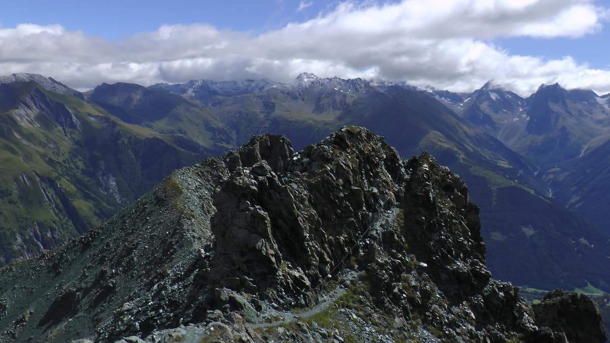
Schober Group - Hohe Tauern National Park
Schobergruppe - Hohe Tauern
East Tyrol / Carinthia (Lienz / Debanttal) · Austria
Photo: FkMohr · CC BY-SA 3.0 de · Wikimedia Commons
Heart of high alpine rock and silence with 30 summits above 3.000 m and no cable cars in the Eastern Alps.
Here there are no cable cars, no ski lifts, and no roads. The Schober Group is a high mountain massif in the southern Hohe Tauern between East Tyrol and Carinthia, with more than 400 peaks and cirques and some thirty peaks over 3.000 meters. The highest is Petzeck at 3.283 m, and the entire heart of the massif is preserved as a strict core zone. The main natural access route is the Debanttal, an alpine valley that penetrates deep into the heart of the massif from near Lienz.
What makes it unique
More than 25.000 hectares of high alpine wilderness where 95 % of the territory is strict nature reserve (IUCN Category 1).
The place
Nature
The landscape
Water and frost shattered the rock. Today the massif preserves twenty-five glaciers covering around 2,5 km², and in the Debanttal only relict ice masses remain, the largest being the Viehkofelkees below the Ralfkopf.
The valley extends sixteen kilometers, considered by the park authorities to be the longest enclosed alpine pasture valley in Austria. Through it flows the Debantbach torrent. Ascending, the landscape shifts in elevational zones: spruce forest at the lower entrance up to Seichenbrunn; followed by larch pasture shaped by human history; and beyond Hofalm, old-growth larch and Swiss stone pine forest. Historic logging depressed the treeline to 2.000 meters, though its natural potential lies between 2.300 and 2.400 meters. Above, rusty-leaved alpenrose and bilberry dominate hollows where snow lingers longest, while at the source of the Debantbach at 2.300 meters, a spring mire gathers rare mosses and plants such as starry saxifrage. Beneath the three-thousand-meter peaks, vast boulder screes dominate.
Wildlife and seasons
Isolation here fosters thriving wildlife. The Debanttal is rich in large game and represents one of the park areas with the most red deer; roe deer, chamois, and an abundant population of alpine marmots are also widespread. Marmots live in family clans in burrows between 1.400 and 2.700 meters, communicating through whistles: a sequence warns of danger on the ground; a single whistle signals an approaching eagle. If you hear it, look skyward. The valley shelters two nesting pairs of golden eagle, and in 2014 two bearded vultures were released, continuing reintroductions underway in the Hohe Tauern since 1986. Occasionally alpine ibex descend from Kals or Heiligenblut, and the Eurasian lynx also roams the valley.
The mountain calendar is marked by blooms. Alpenrose paints the slopes bright pink between May and early July, depending on altitude. Winter belongs to few: occasional ski mountaineers explore the western headwaters, as plans to develop the valley for downhill skiing were permanently abandoned due to high avalanche risk.
Species
With a page in the atlas
Being mentioned in a source doesn't guarantee sightings: check with the people who manage the area.
Memory and protection
History and conservation
The Debanttal is historically a valley of alpine herders. High pastures and hayfields are worked primarily by farmers from Nußdorf-Debant, with many community-held alms. Historic clearing opened pastures in less productive timber, which is why the forest margin ends lower than natural conditions dictate.
Hohe Tauern National Park was established in 1981 as Austria's first national park. With 332 glaciers and the largest contiguous Natura 2000 sanctuary in Austria, it also shelters around 1.100 alpine ibex, successfully reintroduced from the sixties onward.
Before you set off
Visiting
How to visit
Everything starts at the Seichenbrunn parking area. From Lienz, head toward Nußdorf-Debant and follow signs into the Debanttal within the national park.
The gentlest excursion is the nature and culture theme trail, following the Debantbach past Gaimberger Alm and Hofalm to the Lienzer Hütte: an hour and a half, roughly 300 meters of elevation gain, easy and family-friendly. Interpretive panels explain lichen ecology, wetland value, birds of the larch-stone pine forest, and historic alpine transhumance; a small alpine dairy museum stands beside Hofalm.
For more demanding hiking, the Lienzer Hütte serves as the hub for long routes. A round trip to Lake Gartlsee at 2.571 meters takes five hours and some 500 meters of ascent over loose scree requiring surefootedness. The Lienzer Höhenweg offers a five-hour circuit that, after a gentle traverse to Trelebitsch Alm, drops 300 meters back to Seichenbrunn. For a two-day trek, the route from Seichenbrunn to Wangenitzsee hut and Lienzer Hütte totals six hours and 890 meters of ascent; from the Untere Seescharte at around 2.530 meters, you gaze upon Kreuzsee and Wangenitzsee right below the shelter. Ambitious mountaineers can tackle Petzeck from Seichenbrunn: 16,6 kilometers, ten hours, and high difficulty. The Lienzer Hütte can also be reached along the Wiener Höhenweg from the east or the Lienzer Höhenweg from Zettersfeld, and mountain biking is permitted on designated tracks.
Before you go
High-altitude trails demand sturdy alpine boots, surefootedness, and proper mountain gear. The Lienzer Hütte is the only mountain lodge in the Debanttal, so plan multi-day itineraries with it as your base. The valley theme path is gentle; ascents like Gartlsee require solid mountain walking experience.
Check access, rules and visiting conditions in the official information from the managing body before you set off.
Location
Where it is and how far it reaches
Boundary of Schobergruppe · © OpenStreetMap contributors (ODbL) The coordinate is estimated; it isn't a verified access point.
Transparency
Sources
The research data with its sources, and the official links for this place, are in the Spanish version of this page. See the Spanish version
Around it
At 5 km lies Hohe Tauern National Park - Umbal Valley and Upper Isel, and at 6 km the Ankogel Group - Hohe Tauern, two other sectors of the same park. Further afield, Vanoise National Park and Gran Paradiso National Park share alpine ibex, golden eagles, chamois, glaciated peaks, and high mountain silence with the Schober Group.
What else to explore nearby
Approximate straight-line distance between the edges of each area. It doesn't indicate access, routes or driving times.
- Hohe Tauern National Park - Umbal Valley and Isel Headwaters
East Tyrol / Carinthia / Salzburg (Matrei in Osttirol / Prägraten)
About 11 km away
The largest National Park in the Alps and Central Europe (1.800 km²), sheltering the Grossglockner (3.798 m) and the wild Isel glacial river.
JFMAMJJASONDJune – October · Crowding low
- Ankogel Group - Hohe Tauern
Carinthia / Salzburg (Mallnitz / Bad Gastein)
About 23 km away
The 'Gateway to the Tauern', crystalline massif of the Ankogel (3,252 m) with retreating glaciers and pristine alpine alluvial valleys.
JFMAMJJASONDJune – October · Crowding low
If you like this place, elsewhere in Europe
Distant places with uncommon wildlife and habitats in common. The most widespread species don't count. Sharing species doesn't imply a corridor or guaranteed presence.
- Écrins National Park - Alpine Massif
Auvergne-Rhône-Alpes / Provence-Alpes-Côte d'Azur (Isère / Hautes-Alpes)
In common: Alpine ibex · Chamois · Golden eagle — high mountain, glacial landscape
The glaciated core of the French Alps (Barre des Écrins 4.102 m), with deep glacial valleys such as Valgaudemar and Vénéon.
JFMAMJJASONDJune – October · Crowding low
- Vanoise National Park
Auvergne-Rhône-Alpes (Savoie)
In common: Alpine ibex · Chamois · Golden eagle — high mountain, glacial landscape
France's first national park (1963), created to save the Alpine ibex: glaciers, alpine grasslands, and one of the Alps' greatest ibex populations.
JFMAMJJASONDJune – September · Crowding moderate
- Maritime Alps Natural Park
Piedmont (Cuneo / Valdieri / Entracque)
In common: Alpine ibex · Chamois · Golden eagle — high mountain, glacial landscape
United with France's Mercantour National Park, it forms a massive cross-border Alpine-Mediterranean wilderness crowned by Mount Argentera (3.297 m).
JFMAMJJASONDJune – October · Crowding low
- Gran Paradiso National Park
Aosta Valley / Piedmont (Cogne / Valsavarenche / Ceresole Reale)
In common: Alpine ibex · Chamois · Golden eagle — high mountain, glacial landscape
Italy's oldest national park (1922): the last surviving Alpine ibex population held out here and repopulated the entire range.
JFMAMJJASONDJune – September · December – January · Crowding moderate
Entry #343 of the original atlas.