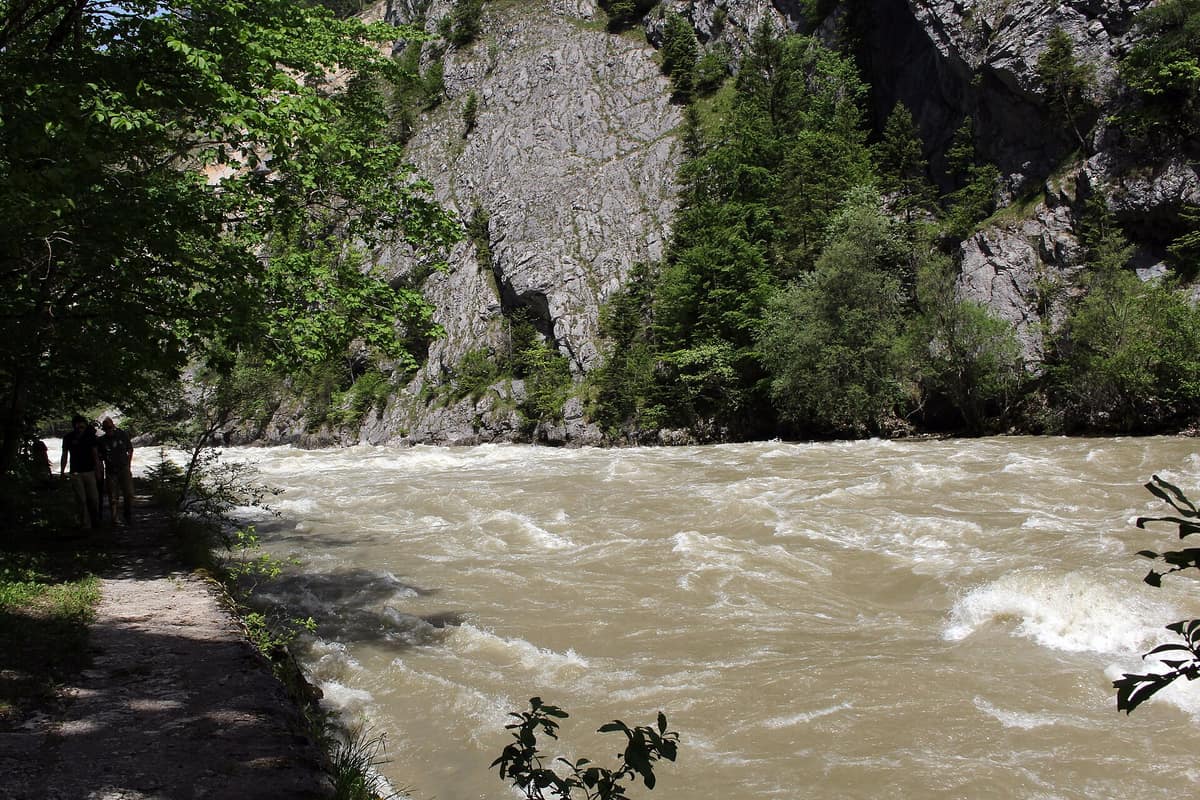
Gesäuse National Park - Enns Gorge
Nationalpark Gesäuse - Enns Gorge
Styria (Admont / Hieflau) · Austria
Photo: Haeferl · CC BY-SA 3.0 at · Wikimedia Commons
Vertical limestone precipices towering over 1.000 m above the thundering whitewater of the Enns river.
The national park owes its name to the rushing, foaming whitewater of the Enns, which cuts a passage through sheer rock ramparts in one of the grandest gorges of the Eastern Alps, framed by soaring limestone peaks rising from 500 m to the 2.369 m summit of the Hochtor. Gesäuse National Park encompasses 12.000 hectares of Upper Styria, was founded in 2002, and adheres to a simple principle: nature decides.
What makes it unique
Nowhere in Austria harbours more endemic species than the Gesäuse, and many cling directly to its sheer limestone walls.
The place
Nature
The landscape
Four fundamental elements define the park: water, woodland, alpine pasture, and rock. That is why the park emblem features three colour bands: blue, green, and grey. The rock is dolomite, and dolomite crumbles easily: it yields enormous volumes of scree that the Enns and Johnsbach torrents carry and deposit into extensive gravel banks where common sandpipers nest. Rushing violently one moment and idling quietly the next, the Enns absorbs the tempestuous mountain waters of the Johnsbach.
Slightly more than half of the park is cloaked in forest: riverside willow and alder thickets alongside sycamore and ash along the valley floor, relict winter heath pine woods surviving from glacial times, and montane fir-beech woods mixed with spruce. Higher up grows the easternmost outpost of Swiss stone pine, while dense creeping mountain pine cushions the slopes above the timberline.
Above all towers bare rock. Across these sheer mountain flanks clings the delicate feathered pink, a floral jewel strictly endemic to the Northern Limestone Alps.
Wildlife and seasons
Amid the jagged limestone crags live the Eurasian lynx, the golden eagle, and the endemic harvestman Megabunus lesserti, which lives exclusively on limestone cliffs between Lugauer and Buchstein. The lynx disappeared from Austria around 1900 due to intense hunting persecution; in 2011 its reintroduction began in the adjacent Kalkalpen National Park with the release of the female Freia.
The golden eagle is a permanent resident, frequently seen soaring along the ridges. You are very likely to spot chamois across the craggy heights; encountering marmots or red deer requires greater patience. In the montane woodlands you can hear the resonant drumming of the white-backed woodpecker, which depends on mixed beech forests rich in standing deadwood, and on still spring nights echoes the fluting call of the boreal owl. With luck, the wallcreeper flashes its crimson wings against steep torrent ravines. Park rangers offer guided outings to track secretive inhabitants such as the western capercaillie.
Species
With a page in the atlas
Being mentioned in a source doesn't guarantee sightings: check with the people who manage the area.
Memory and protection
History and conservation
It is an IUCN Category II national park: commercial forestry and gravel extraction are strictly forbidden, the sole exception being traditional alpine pastures whose historical grazing regime is essential for cultural biodiversity. The natural wilderness zone encompasses around 75 % of the park area and will remain entirely free from human intervention once scheduled transition measures conclude.
Before you set off
Visiting
How to visit
You experience the national park on foot. Walking here means taking in vistas of jagged limestone spires and the swirling Enns deep below, along numerous waymarked footpaths and guided routes tailored to various fitness levels. Visitor centres welcome you at the Weidendom and Gstatterboden. The Weidendom, situated beside the Enns near the Johnsbach turnoff, offers educational programmes showcasing wilderness dynamics, and its grounds remain open year-round. The Admont information office and the Gstatterboden pavilion sell printed topographic maps. A specialized photo guide highlights choice scenic viewpoints and seasonal lighting.
Johnsbach warrants an overnight stop: the darkest night skies ever recorded in an Austrian settlement were measured here, and the Milky Way arches brightly to the naked eye. For almost a century the Gesäuse has been celebrated as the «university of mountaineering».
Before you go
Camping (except at the official Forstgarten campsite in Gstatterboden), open fires, parking outside designated areas, off-leash dogs, drones, and entering caves are prohibited. You must stay on marked paths: the banks of the Enns and Johnsbach are closed off outside designated gravel bars, and in winter wildlife resting zones are enforced. Be prepared for avalanches, rockfalls, sudden mountain mists, and rapid weather shifts, keeping in mind that most alpine tracks demand sure-footedness. European vipers and ticks occur.
Check access, rules and visiting conditions in the official information from the managing body before you set off.
Location
Where it is and how far it reaches
Boundary of Nationalpark Gesäuse · IUCN II · © EEA, CDDA (CC-BY) The coordinate is estimated; it isn't a verified access point.
Transparency
Sources
The research data with its sources, and the official links for this place, are in the Spanish version of this page. See the Spanish version
Around it
The Hochschwab Group lies some three kilometres away. About thirteen kilometres distant spreads the Kalkalpen National Park - Forest Areas, and some sixteen kilometres away rises the Totes Gebirge Karst Desert. Around twenty-two kilometres away rests the Dürrenstein-Lassingtal Wilderness Area.
What else to explore nearby
Approximate straight-line distance between the edges of each area. It doesn't indicate access, routes or driving times.
- Hochschwab Group
Styria (Aflenz / Mariazell)
About 3 km away
Vast, desert-like karst plateau above 2,000 m hosting the largest concentration of chamois in the Alps.
JFMAMJJASONDJune – October · Crowding low
- Kalkalpen National Park - Forest Areas
Upper Austria (Steyr-Land / Kirchdorf)
About 11 km away
Austria's largest contiguous tract of broadleaf forest and the grandest wilderness recovery area in the Northern Limestone Alps.
JFMAMJJASONDMay – October · Crowding low
- Totes Gebirge - Karst Desert
Upper Austria / Styria (Hinterstoder / Bad Aussee)
About 20 km away
The 'Dead Mountains', Central Europe's largest high-alpine karst desert plateau (over 200 km² of exposed barren limestone void of surface water).
JFMAMJJASONDJune – October · Crowding low
- Dürrenstein-Lassingtal Wilderness Area
Lower Austria (Ybbstal Alps)
About 22 km away
The largest unmanaged primeval forest in the Central Alps (Rothwald), UNESCO World Heritage site.
JFMAMJJASONDJune – October · Crowding very low
If you like this place, elsewhere in Europe
Distant places with uncommon wildlife and habitats in common. The most widespread species don't count. Sharing species doesn't imply a corridor or guaranteed presence.
- Retezat National Park
Hunedoara County (Hațeg)
In common: Ichthyosaura alpestris · Cypripedium calceolus · Chamois — high mountain, old-growth forest
The realm of the granitic and glacial Retezat, with over 80 crystal tarns and the Gemenele scientific reserve.
JFMAMJJASONDJune – October · Crowding low
- Sagittario Gorge Nature Reserve
Abruzzo (Anversa degli Abruzzi / Scanno)
In common: Wallcreeper · White-backed woodpecker · White-throated dipper — gorge and canyon, river corridor
An awe-inspiring karst canyon carved by the Sagittario River between vertical limestone cliffs hundreds of metres high.
JFMAMJJASONDMay – October · Crowding very low
- Domogled - Cerna Valley National Park
Caraș-Severin, Mehedinți, and Gorj Counties
In common: Cypripedium calceolus · White-backed woodpecker · Chamois — high mountain, gorge and canyon
Deep tectonic canyon flanked by Banat black pine and catchments with virgin montane beech woods.
JFMAMJJASONDMay – October · Crowding very low
Entry #345 of the original atlas.