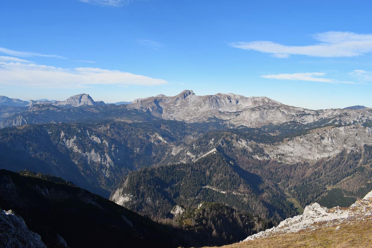
Hochschwab Group
Hochschwabgruppe
Styria (Aflenz / Mariazell) · Austria
Photo: Schreckgespenst · CC BY-SA 4.0 · Wikimedia Commons
Vast, desert-like karst plateau above 2,000 m hosting the largest concentration of chamois in the Alps.
It rains, it snows, yet not a single stream flows across the high plateau. That is the hydrological wonder of the Hochschwab: a limestone massif so riddled with fissures that every drop of surface moisture vanishes underground, re-emerging at the periphery in immense karst springs that feed the drinking taps of Vienna. This is the Hochschwabgruppe, a mountain massif of some 400 km² in northern Styria, Austria, culminating at the summit of Hochschwab at 2277 m, explored from base to crest amidst rock walls, cirques, limestone pavement, and alpine huts.
What makes it unique
A mountain that swallows its own rain through sinkholes and subterranean caverns, returning it in peripheral springs supplying Vienna's tap water.
The place
Nature
The landscape
The Hochschwab is a high mountain massif of the Northern Limestone Alps, a desert-like plateau primarily composed of Wetterstein limestone—a carbonate rock readily dissolved by acidic water. That is the genesis of its karst topography. The elevated plateau surfaces were uplifted during the Miocene with the Alpine orogeny: above some 1330 m they form rolling, undulating terrain that breaks abruptly into sheer peripheral precipices dropping into surrounding valleys. The plateau is bounded by the Seeberg Pass to the east and the Präbichl Pass to the west.
Rain and snow melt seep through grikes and sinkholes into subterranean caverns; beneath the permeable limestone lie impervious Werfen geological strata forcing groundwater back out through powerful perimeter springs. This explains the barren surface: expansive limestone pavements (Karren) and deep dolines, including a giant sinkhole north of Lake Sackwiesensee measuring 600 × 300 m with a depth of 70 m. Subterranean exploration has catalogued 932 caves, including the Frauenmauer-Langstein cave system extending over 45 km.
Glacial ice and rockfalls also sculpted the terrain. During the Würm glaciation, an ice cap mantled the northern massif, leaving cirques along its flanks. Glacial erosion carved the Obere Dullwitz valley and left distinct morainic hallmarks around Lake Leopoldsteiner See near Eisenerz. Furthermore, between 3900 and 3700 BC, a colossal rock avalanche detached between Ebenstein, Großer Griesstein, and Brandstein, thundering down the Salza valley well past Wildalpen. Two other prehistoric rockslides in Tragöß dammed the famous Grüner See and Pfarrerlacke.
Several mountain lakes, such as Lake Leopoldsteiner See, Lake Brunnsee, and the emerald Grüner See in Tragöß, boast drinking-water clarity. Lake Sackwiesensee and Lake Teufelssee, nestled between Eisenerz and Wildalpen, are other well-known alpine waters.
Wildlife and seasons
The fauna of the massif includes the alpine marmot, the chamois, the Alpine ibex, and the western capercaillie, along with alpine salamanders and the common viper. Plant life is exceptionally rich: mountain auricula, lady's slipper orchid, black vanilla orchid, edelweiss, and multiple gentian species.
Species
With a page in the atlas
Being mentioned in a source doesn't guarantee sightings: check with the people who manage the area.
Memory and protection
History and conservation
The name Hochschwab probably derives from the Schwabenboden, the high pastoral shelves flanking the summit, which later gave their name to the peak and the entire massif. The earliest known depiction of the Hochschwab, drawn by a Renaissance cartographer, portrays two snow-clad summits inscribed with the legend "snow lies here forever".
The massif plays a crucial role in water supply: the city of Vienna draws about 60 % of its municipal drinking water through the Second Spring Water Pipeline, completed in 1910. The Kläffer springs along the Salza valley constitute one of the mightiest drinking spring discharges in the Eastern Alps.
Before you set off
Visiting
How to visit
Mountain huts operated by the Alpine Club, an extensive footpath network, and several winter sports zones make the massif well-equipped for mountain trekking. The classic route ascends the Hochschwab from Seewiesen at 974 m via the Seetal valley, the Untere Dullwitz, the Voisthaler Hut, the Obere Dullwitz, and the Graf-Meran-Steig trail to reach the Schiestlhaus. The Schiestlhaus can also be reached from the north via Weichselboden in the Salza valley.
From the Schiestlhaus, the rounded plateau summit of the Hochschwab, crowned by rock and alpine meadows, is reached in just half an hour. The formidable South Face forms the massif's greatest mountaineering wall: nearly two kilometres wide and up to 300 m high. Crossing the summit are the North-South long-distance trail 05 (reaching its highest elevation here), the Northern Alpine Way 01, and the European long-distance paths E6 and E4.
The modern Schiestlhaus, reopened in 2005, is the highest passive mountain house in the world, having replaced a venerable shelter dating back 120 years. Near Bodenbauer in Thörl, a dedicated museum illuminates the natural history of the Hochschwab.
Before you go
This is high limestone karst terrain: with no flowing streams on the high plateau, you must carry all the water you need. The upper plateau experiences severe mountain weather, so check hut openings and trail conditions before departing.
Check access, rules and visiting conditions in the official information from the managing body before you set off.
Location
Where it is and how far it reaches
Boundary of Hochschwab · IUCN V · © EEA, CDDA (CC-BY) The coordinate is estimated; it isn't a verified access point.
Transparency
Sources
The research data with its sources, and the official links for this place, are in the Spanish version of this page. See the Spanish version
Around it
Just 3 km away lies Gesäuse National Park, and slightly further the Dürrenstein-Lassingtal Wilderness Area and Kalkalpen National Park. Further afield, Karwendel Nature Park, Adamello-Brenta Nature Park, the Ankogel Group, and Écrins National Park share with the Hochschwab populations of Alpine ibex and chamois.
What else to explore nearby
Approximate straight-line distance between the edges of each area. It doesn't indicate access, routes or driving times.
- Gesäuse National Park - Enns Gorge
Styria (Admont / Hieflau)
About 3 km away
Vertical limestone precipices towering over 1.000 m above the thundering whitewater of the Enns river.
JFMAMJJASONDMay – October · Crowding low
- Dürrenstein-Lassingtal Wilderness Area
Lower Austria (Ybbstal Alps)
About 14 km away
The largest unmanaged primeval forest in the Central Alps (Rothwald), UNESCO World Heritage site.
JFMAMJJASONDJune – October · Crowding very low
- Kalkalpen National Park - Forest Areas
Upper Austria (Steyr-Land / Kirchdorf)
About 22 km away
Austria's largest contiguous tract of broadleaf forest and the grandest wilderness recovery area in the Northern Limestone Alps.
JFMAMJJASONDMay – October · Crowding low
If you like this place, elsewhere in Europe
Distant places with uncommon wildlife and habitats in common. The most widespread species don't count. Sharing species doesn't imply a corridor or guaranteed presence.
- Karwendel Nature Park
Tyrol (Innsbruck / Scharnitz) (AT) / Bavaria (Mittenwald) (DE)
In common: Alpine ibex · Chamois — high mountain, karst and caves
Tyrol's largest Nature Park, with 4 parallel limestone ranges plunging sheer into gorges and the famous ancient sycamore-maple wood-pasture Großer Ahornboden.
JFMAMJJASONDJune – October · Crowding low
- Adamello-Brenta Natural Park
Trentino (Pinzolo / Madonna di Campiglio / Tovel)
In common: Alpine ibex · Chamois — high mountain, karst and caves
Two opposing geological worlds facing each other: the limestone spires of the Brenta Dolomites and the glaciated granite massif of the Adamello (home to Trentino's historic brown bear).
JFMAMJJASONDJune – October · Crowding moderate
- Ankogel Group - Hohe Tauern
Carinthia / Salzburg (Mallnitz / Bad Gastein)
In common: Alpine ibex · Chamois — high mountain
The 'Gateway to the Tauern', crystalline massif of the Ankogel (3,252 m) with retreating glaciers and pristine alpine alluvial valleys.
JFMAMJJASONDJune – October · Crowding low
- Écrins National Park - Alpine Massif
Auvergne-Rhône-Alpes / Provence-Alpes-Côte d'Azur (Isère / Hautes-Alpes)
In common: Alpine ibex · Chamois — high mountain
The glaciated core of the French Alps (Barre des Écrins 4.102 m), with deep glacial valleys such as Valgaudemar and Vénéon.
JFMAMJJASONDJune – October · Crowding low
Entry #346 of the original atlas.