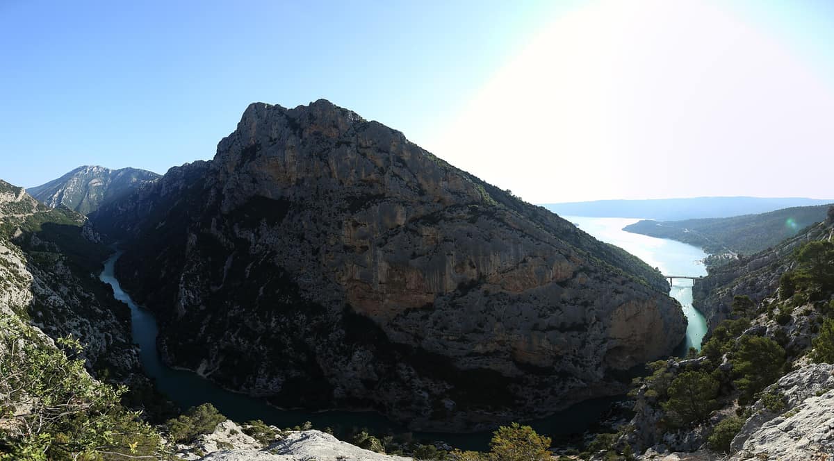
Verdon Regional Natural Park - Grand Canyon
Parc Naturel Régional du Verdon - Gorges
Alpes-de-Haute-Provence / Var (Castellane / Moustiers-Sainte-Marie) · France
Photo: Tom Chirossel · CC BY-SA 4.0 · Wikimedia Commons
The 'Grand Canyon of Europe', sheer limestone cliffs plunging 700 m carved out by the turquoise waters of the Verdon River.
In 1905, Édouard-Alfred Martel and Isidore Blanc traversed the Verdon gorge from end to end, transforming Europe's Grand Canyon from a blank spot on the map into a celebrated wonder. What they unveiled is a chasm between 250 and 700 metres deep, narrowing at the riverbed to between 6 and 100 metres wide. Today, the Verdon Regional Natural Park covers 188 000 hectares across the departments of Alpes-de-Haute-Provence and Var, organized around the watershed of the river that lends its name, inspired by the vivid turquoise hue of its waters.
What makes it unique
A limestone canyon dropping up to 700 metres, a river vanishing subterraneanly at the Imbut, and vultures returned to nest along its sheer walls.
The place
Nature
The landscape
The narrative begins beneath an ancient sea. During the Triassic, Provence subsided and the sea laid down thick calcareous sediments; in the Jurassic, warm, shallow waters fostered extensive coral growth. Much later in the Tertiary, the Alpine orogeny buckled the terrain, prompting the ancestral Verdon to cut into the limestone as the mountains rose. Mont Chiran belongs to this pre-Alpine limestone massif around Castellane.
At the Imbut, the Verdon plunges subterraneanly beneath a colossal chaos of fallen boulders. At the downstream exit of the gorge, the hydrology tells another story: the filling of the Sainte-Croix reservoir in 1973 submerged the agricultural plain and the old village of Les Salles-sur-Verdon, reconstructed on higher ground. On the right bank bordering the lake, the Verdon tufa terraces form a designated regional nature reserve.
The great gorge also provides a sheltered microclimatic haven: sheltering endemic cliff flora, cliff-dwelling birds, and specialized bats. The left bank is cooler and clad in deciduous woodland of beech and oak, with the Aiguines beech forest managed as a directed biological reserve. Overall, 63 % of the park area is forest, 32 % is agricultural or pasture land, and only 3 % is built up. The flora numbers 2 200 species, representing one third of all plant species in France, including the Verdon spleenwort (Asplenium jahandiezii), a rare chasmophytic fern discovered in the gorge in 1911.
Wildlife and seasons
Cast your eyes toward the cliffs. The park's rock-dwelling birds include the golden eagle, red-billed chough, peregrine falcon, common raven, bearded vulture, and Eurasian eagle-owl. Yet the undisputed masters of the air are the vultures. The griffon vulture, reintroduced in 1999, now nests across the gorge walls with over 200 breeding pairs closely monitored by the LPO. Cinereous vultures also frequent the gorge corridors.
In winter, the park recommends the Grand Margès summit to spot vultures overlooking Lake Sainte-Croix, while the LPO leads interpretive outings to observe the Verdon's scavengers.
Ashore, terrestrial wildlife remains discreet. You may encounter chamois, singly or in small groups, along the bends of the canyon paths. The park harbours some 50 mammal species, including 22 bat species out of the 32 recorded in metropolitan France. Larger mammals include roe deer, wild boar, Eurasian lynx, wolf, badger, and the common genet. In the river, the critically endangered Rhône streber bears witness to the pristine water quality of the Verdon.
Spring and autumn offer the finest conditions for the Blanc-Martel trail. In spring, ascending Mount Teillon lets you walk amid mountain wild blooms, while on clear summer nights the astronomical observatory on Mont Chiran invites stargazing.
Species
With a page in the atlas
Being mentioned in a source doesn't guarantee sightings: check with the people who manage the area.
Memory and protection
History and conservation
Caves in the lower gorges have sheltered human populations since prehistoric times, with findings exhibited at the Museum of Prehistory in Quinson.
The regional natural park was officially founded by decree on 3 March 1997. The gorge itself has been protected as a classified natural site since 1990, securing long-term core preservation, and the park charter was renewed on 28 April 2025 for the 2025-2040 term, embracing 54 member communes. Avian protection carries direct consequences: certain climbing sectors are closed seasonally to safeguard nesting ledges of reintroduced vultures amid growing recreational pressures.
Before you set off
Visiting
How to visit
The definitive footpath through the gorge is the Blanc-Martel trail: fifteen kilometres between the Chalet de la Maline and Point Sublime, involving some 600 metres of cumulative ascent. The hike down to the Couloir Samson spans 12 km. To walk it from the village of La Palud-sur-Verdon, a park shuttle operates to the trailhead while cars are parked in designated bays.
Other classic gorge hikes include the Sentier de l'Imbut, the Sentier du Bastidon, and the Rancoumas lookout via the Tusset bridge. The Martel trail was laid out in 1928 by the Touring Club de France and named in 1930 in honour of the speleologist.
To interpret the landscapes: the Maison de site in Rougon by Point Sublime guides visitors across both rims. The Valx-Félines estate, owned by the Conservatoire du littoral and managed by the park, houses the Maison du Parc, an educational goat farm, and an interpretive nature trail open year-round. Along the paths, park eco-guards in beige uniforms provide guidance on conservation rules and route safety.
Before you go
Hikers must remain on marked paths to prevent trampling fragile cliff vegetation and endemic invertebrates. Always heed seasonal climbing cliff closures designed to safeguard nesting vultures.
Check access, rules and visiting conditions in the official information from the managing body before you set off.
Location
Where it is and how far it reaches
Boundary of Gorges Du Verdon · © EEA, CDDA (CC-BY) The coordinate is estimated; it isn't a verified access point.
Transparency
Sources
The research data with its sources, and the official links for this place, are in the Spanish version of this page. See the Spanish version
Around it
Farther away, other karst landscapes share raptors and limestone walls: Parc Natural dels Ports shares bearded and Egyptian vultures in deep limestone gorges, Parque Natural Hoces del Río Duratón hosts Egyptian vultures, eagle-owls, and griffons, while the Gorges du Tarn share choughs, cinereous vultures, and griffon vultures.
If you like this place, elsewhere in Europe
Distant places with uncommon wildlife and habitats in common. The most widespread species don't count. Sharing species doesn't imply a corridor or guaranteed presence.
- Els Ports Natural Park
Catalonia / Aragon / Valencian Community (Tarragona / Teruel / Castellón / Roquetes / Tortosa)
In common: Circaetus gallicus · Bearded vulture · Cinereous vulture — gorge and canyon, karst and caves
A rugged karst massif between Catalonia, Aragon, and the Valencian Community featuring limestone cliffs, southern beech groves, and the Iberian ibex.
JFMAMJJASONDApril – June · September – November · Crowding low
- Hoces del Río Duratón Natural Park
Castile and León (Segovia / Sepúlveda / Sebastopol / San Frutos)
In common: Egyptian vulture · Griffon vulture · Eurasian eagle-owl — gorge and canyon, karst and caves, river corridor
Incised meanders 100 m deep carved into red limestone by the Duratón River, featuring the renowned cliffside hermitage of San Frutos.
JFMAMJJASONDApril – June · September – October · Crowding moderate
- Paklenica National Park - Velebit Plateau
Zadar County (Starigrad-Paklenica)
In common: Circaetus gallicus · Griffon vulture · Eurasian eagle-owl — gorge and canyon, karst and caves
Vertical incised canyons (Velika and Mala Paklenica) plunging straight towards the Adriatic Sea from the crests of Velebit.
JFMAMJJASONDApril – June · September – October · Crowding low
Entry #383 of the original atlas.