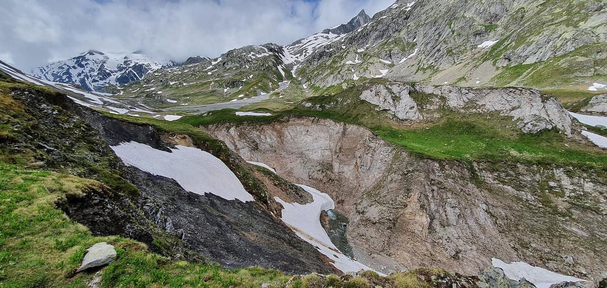
Greina Plateau
Plaine de la Greina / Passo della Greina
Grisons / Ticino (Vrin / Olivone) · Switzerland
Photo: Oliylkaeng · CC BY-SA 4.0 · Wikimedia Commons
An alpine tundra plateau at 2,200 m without a single building, saved from a reservoir project in 1996.
A river meanders unhurriedly across a plain above 2000 m where there is not a single tree, house, or road. The Greina is a plateau about six kilometres long and one wide, at 2200 m, on the border between Grisons and Ticino, and what makes it famous is what it lacks: neither roads nor cable cars, so crossing it typically requires an excursion of two or more days. A reservoir nearly swallowed it. Today it is a milestone of Swiss conservation.
What makes it unique
An alpine tundra without a single construction, saved from being submerged beneath a reservoir.
The place
Nature
The landscape
The plateau is not a perfect flat: it appears rather as a landscape of hills, terraces, and rocky ribs on either side of the river. The Rein da Sumvitg meanders across it, and the scenery is sometimes compared to northern tundras, because trees from the valleys have been unable to reach here. Eleven three-thousanders surround it, and a section of the European watershed passes along the alpine crest of the protected area.
The Greina is a key to Alpine geology. Erosion exposes folds and overthrusts through which the transformation of minerals and the formation of the Alps can be reconstructed. From the northwest descends the crystalline Gotthard massif nappe, made of gneiss, and from the south the Adula nappe collides with it, carrying Penninic sediments and Grisons schists. To the west, vertical beds of light dolomite, marble, and rauwacke dominate the valley floor.
Ice did the rest. During the glacial maximum, the ice surface stood at around 2900 m, more than 600 m above the plain. The erratic block of augen gneiss, Crap la Crusch, was carried by the glacier from the Gotthard area, and within the protected territory lies a massive morainic wall left by a late glacier some 8000 years ago. The last remnants of glaciers are the Glatscher dalla Greina, the Glatscher da Gaglianera, and the Glatscher dil Terri, which nourish the plain with meltwater. Near the pass, a natural limestone rock arch of about forty metres is widely admired. And at 2585 m, beneath Piz Terri, lies Laghet la Greina, the only large mountain lake.
Wildlife and seasons
In the brief summer, the flora is remarkably diverse. In the youthful soils of the plain grows the two-coloured rush, a rare relict, and in the alpine pastures there are sulphur anemone, mountain buttercup, alpine snowbell, snow gentian, and alpine forget-me-not, among others. Ticino poet Plinio Grossi described the plateau as a 'geological museum' and 'botanical garden'.
The wildlife is discreet. In the open, treeless landscape, the Alpine marmot and the common adder, which is endangered here, find good habitat. Mammals of the federal reserve include the chamois and the Alpine ibex, and management plans foresee regulating the latter to reduce grazing impact and competition with the former. Another conservation goal is preserving the diversity of grouse populations.
Species
With a page in the atlas
Being mentioned in a source doesn't guarantee sightings: check with the people who manage the area.
Memory and protection
History and conservation
The Greina was repeatedly threatened in the twentieth century by power plant projects. The scheme planned a reservoir across the plateau, submerging its alluvial plain, and a hydroelectric station in the Blenio Valley.
Among the organisations that campaigned to preserve it was the Swiss Greina Foundation for the Protection of Alpine Waters, established on 15 August 1986. Ultimately, the power industry shelved the reservoir for economic reasons, the landscape entered the federal inventory in 1996, and since 1997 the municipalities have received compensation for relinquishing the power plant. Since 2004 the area has been designated a federal game reserve, 'Pez Vial/Greina'. Today, cattle grazing has caused trampling damage to the low bogs, particularly across the southwestern half of the alluvial plain.
Before you set off
Visiting
How to visit
The plateau is reached from three valleys connected by trails: Val Lumnezia, Val Sumvitg, and the Blenio Valley. It is best to ascend via one and descend by another. The Bus alpin runs from Vrin to Puzzatsch and from Rabius to Runcahez, while on the Ticino side a line operates from Olivone to Pian Geirett and Lago di Luzzone.
The classic crossing takes two days. The first stage sets off from Vrin/Puzzatsch, ascends to the Diesrut Pass at 2428 m, the 'gateway to the Greina', with a steady climb taking about two and a half hours from Puzzatsch, and traverses the plateau. Shortly after the pass, descending onto the plain, you cross the Punt la Greina suspension bridge, 65 m long and 40 m high above the Rein da Sumvitg. The second stage leads from Terrihütte across Crest la Greina down to Runcahez; the descent is partly more demanding, with chains on rocky sections. Those in top physical condition can complete the crossing in a single day. The published trail profile peaks at 2430 m at its highest point and drops to 1280 m at its lowest. Public transport combines the postbus Ilanz–Vrin and the Bus alpin up to Puzzatsch.
From the Ticino side, the trail starts at the end of a road at about 2000 m; a postbus carries hikers up to that elevation.
Before you go
With uncertain weather you should not start the route: mountain weather changes rapidly, and if a rain front approaches, you must turn back in good time. Sturdy footwear with a deep tread, waterproof clothing, a first-aid kit, water, food, and perhaps walking poles are recommended. The Greina protected district is subject to strict integral protection.
Check access, rules and visiting conditions in the official information from the managing body before you set off.
Location
Where it is and how far it reaches
Boundary of Greina · IUCN IV · © EEA, CDDA (CC-BY) The coordinate is estimated; it isn't a verified access point.
Transparency
Sources
The research data with its sources, and the official links for this place, are in the Spanish version of this page. See the Spanish version
Around it
There are no other atlas sites nearby. At a great distance, the Upper Lötschental, the Queyras Regional Natural Park, the Vanoise National Park, and the Rodna Mountains National Park share with the Greina the chamois, the Alpine marmot, and the high-alpine character.
If you like this place, elsewhere in Europe
Distant places with uncommon wildlife and habitats in common. The most widespread species don't count. Sharing species doesn't imply a corridor or guaranteed presence.
- Queyras Regional Natural Park
Hautes-Alpes (Guillestre / Saint-Véran)
In common: Alpine marmot · Chamois — high mountain
A high alpine larch valley dominated by Mount Viso and punctuated by Saint-Véran, the highest inhabited village in Europe.
JFMAMJJASONDJune – October · Crowding low
- Dachstein Nature Reserve — Gosau, Hallstatt and Obertraun
Upper Austria — Gmunden; Gosau, Hallstatt and Obertraun
In common: Alpine marmot · Chamois — high mountain
Karst topography, glaciers, alpine meadows and old-growth mountain forests above the Gosau lakes.
JFMAMJJASONDMarch – November · Crowding no data
- Vanoise National Park
Auvergne-Rhône-Alpes (Savoie)
In common: Alpine marmot · Chamois — high mountain
France's first national park (1963), created to save the Alpine ibex: glaciers, alpine grasslands, and one of the Alps' greatest ibex populations.
JFMAMJJASONDJune – September · Crowding moderate
Entry #336 of the original atlas.