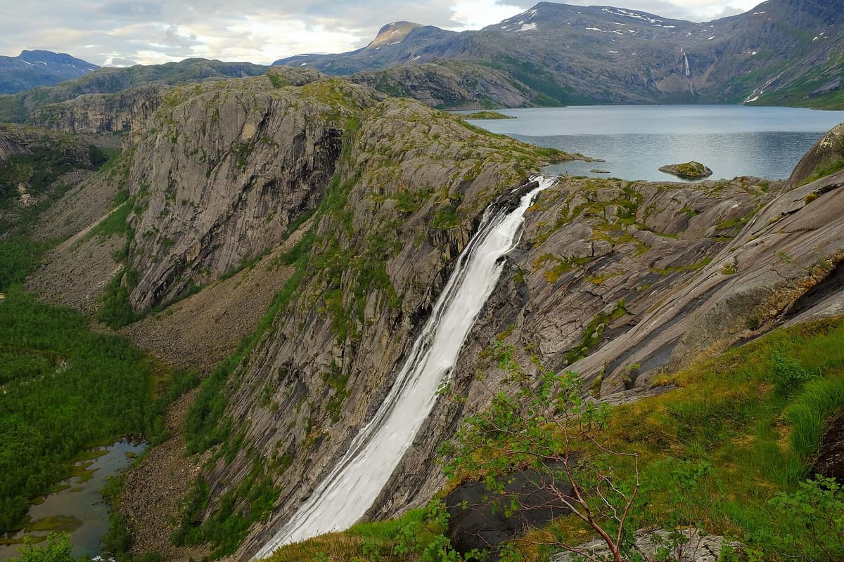
Rago National Park
Nordland (Sørfold / Nordfold) · Norway
Photo: Frankemann · CC BY-SA 4.0 · Wikimedia Commons
An extremely dramatic bare-granite alpine canyon adjoining Padjelanta and Sarek in Sweden, forming a wild transboundary complex of 7,400 km².
In Sami, Rago signifies a 'difficult and impassable mountain tract', and the name sets the tenor. Covering 171 km², Rago is a compact park established on 22 January 1971 to safeguard an unblemished mountain landscape of Nordland, directly adjoining Sweden's Padjelanta, Sarek, and Stora Sjöfallet national parks. Together, the four encompass 5,700 km², creating one of Europe's largest contiguous protected wilderness expanses. Its management plan deliberately treats it as a wilderness park, devoid of tourist infrastructure.
What makes it unique
A near-virgin pine forest at the foot of bare granite, glaciers, and a 223 m waterfall, all within a park that has chosen to remain wild.
The place
Nature
The landscape
Granite reigns supreme. The bedrock consists predominantly of granite-gneiss, a durable rock that weathers agonizingly slowly and generates minimal topsoil, yielding a scoured terrain of polished stone, glacial erratics, and scree slopes hugging cliff bases. River gorges were gouged by glacial meltwaters surging during the ice retreat. Multiple summits surpass a thousand metres, with one of them, Rago, giving its name to the reserve.
To the south, the Lappfjellet massif harbors several small cirque glaciers, and the climate is maritime: heavy rainfall, cool summers, and mild winters. Litlverivatnet empties directly over the Litlverivassforsen waterfall, plunging 223 m.
The most prized woodland element is the pine stand. Rago protects one of the finest natural Scots pine forests in Nordland, where pines ascend almost to the treeline, leaving mountain birch far less dominant than elsewhere in Norway. The old-growth forest shelters numerous red-listed polypores and crust fungi; around Storskogvatnet, 20 red-listed species have been catalogued, primarily on standing dead pine. Around the Flatkjølen glacier in the southeast, calcareous outcrops foster diverse alpine communities, with demanding plants prospering near late snowbeds.
Wildlife and seasons
Rago serves as winter grazing territory for reindeer belonging to the Doukta herding district. The moose is the sole resident cervid; the wolverine maintains dens and hunting circuits here, whereas the Eurasian lynx is only an itinerant visitor. In neighboring Swedish parks brown bears thrive, but in Rago they have remained uncommon since 1900.
In the pine woods dwell black grouse and the Western capercaillie, and in favorable seasons ptarmigan thrive through the birch zones. The red-throated diver is plentiful. Among raptors, hikers may spot the golden eagle and the gyrfalcon, which peak in abundance during rodent population booms.
Species
With a page in the atlas
Being mentioned in a source doesn't guarantee sightings: check with the people who manage the area.
Memory and protection
History and conservation
Sami pastoralists traversed this country to drive reindeer herds from Sweden to coastal summer pastures. An ancient cairned route stretched from Megården via Lappfjellet and Flatkjølen into Sweden: along it Swedish Sami came to barter meat and pelts for fish, salt, and coastal commodities, and during the Second World War refugees used it to escape into neutral Sweden.
The foremost threat to the park's fragile values is summer recreational wear, while climate change poses the gravest danger to cold-adapted rare species.
Before you set off
Visiting
How to visit
The Rago circuit is the defining trek. It can be walked in either direction, beginning from Lakshola or Litjsand. From Lakshola you follow a marked path alongside the crystalline Storskogelva and cross a suspension bridge; the ascent of Nordskaret is steep and slippery, but the summit panoramas reward the effort. After about nine kilometres you reach Storskogvatnet, an ideal spot for wild camping or staying at the unlocked hut at the lake's southern end. The route proceeds towards Sølvskarvatnan and Litlverivatnet across raw alpine terrain, traversing another suspension bridge suspended above the Litlverivassforsen cataract. Following another five kilometres you arrive at Litjsand, followed by a final two kilometres back to your vehicle at Lakshola.
The finest overlook in Rago is Grisryggen, a couple of hundred metres from the bridge: accessed from Litjsand, the first two kilometres climb steeply with nearly 400 m of elevation gain and rest benches, forming a round trip of some 11 km. Another maintained path links Lakshola to Storskogvatnet, measuring about 7 km. The wilderness crossing into Sweden, via Ragohytta to the frontier and Padjelanta, is demanding and only partially signposted.
The Nordland National Park Centre in Storjord (Saltdal) opened in 2005 and serves five national parks, including Rago.
Before you go
The Rago circuit is rugged and requires sturdy footwear along with weather-appropriate layering; a windproof jacket and waterproof trousers are essential. Statskog's open wilderness cabins, Storskogvasshytta and Ragohytta, contain very few bunks and can quickly fill up, especially from June to October; carry a tent. Light campfires solely with brought firewood, as dead standing pines provide irreplaceable habitat for rare fungi. Dogs must be kept on a lead from 1 April to 20 August, and all waste must be packed out.
Check access, rules and visiting conditions in the official information from the managing body before you set off.
Location
Where it is and how far it reaches
Boundary of Rago · IUCN II · © EEA, CDDA (CC-BY) The coordinate is estimated; it isn't a verified access point.
Transparency
Sources
The research data with its sources, and the official links for this place, are in the Spanish version of this page. See the Spanish version
Around it
Padjelanta National Park abuts Rago directly across the border, with Junkerdal National Park lying somewhat farther away. Farther still, Jotunheimen National Park and Børgefjell National Park share the wolverine, and Jotunheimen also shares the golden eagle with high-alpine habitats.
What else to explore nearby
Approximate straight-line distance between the edges of each area. It doesn't indicate access, routes or driving times.
- Padjelanta National Park
Swedish Lapland / Norrbotten (Jokkmokk / Kvikkjokk)
About 1 km away
Sweden's largest national park (198.000 ha), featuring vast alpine lakes Vastenjaure and Virihaure and ancestral Sami grazing lands.
JFMAMJJASONDJuly – September · Crowding very low
- Junkerdal National Park
Nordland (Saltdal / Fauske / Junkerdal)
About 29 km away
Renowned internationally for harboring one of the richest arctic-alpine and karst floras in the entire Arctic, thanks to its soft limestone bedrock.
JFMAMJJASONDJuly – September · Crowding very low
If you like this place, elsewhere in Europe
Distant places with uncommon wildlife and habitats in common. The most widespread species don't count. Sharing species doesn't imply a corridor or guaranteed presence.
- Jotunheimen National Park - Home of the Giants
Innlandet / Vestland (Lom / Gjendesheim / Øvre Årdal)
In common: Wolverine · Golden eagle — high mountain, glacial landscape, lake
The 'Home of the Giants' in Norse mythology, harboring Scandinavia's two highest peaks (Galdhøpiggen 2 469 m and Glittertind) and the legendary Besseggen ridge.
JFMAMJJASONDJune – September · Crowding moderate
- Børgefjell National Park
Trøndelag / Nordland (Hattfjelldal / Røyrvik)
In common: Wolverine · Sea trout — high mountain, lake
One of Scandinavia's purest trail-less wilderness sanctuaries, a core breeding haven for the Arctic fox (Vulpes lagopus).
JFMAMJJASONDJuly – September · Crowding none
Entry #583 of the original atlas.