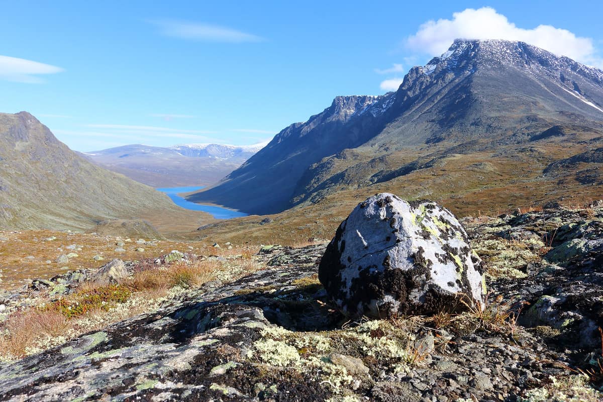
Jotunheimen National Park - Home of the Giants
Jotunheimen National Park
Innlandet / Vestland (Lom / Gjendesheim / Øvre Årdal) · Norway
Photo: FrDr · CC BY-SA 4.0 · Wikimedia Commons
The 'Home of the Giants' in Norse mythology, harboring Scandinavia's two highest peaks (Galdhøpiggen 2 469 m and Glittertind) and the legendary Besseggen ridge.
Trolls, legend tells, dwell within these crags. Caught by the rising sun, they shattered and turned to stone, yielding these fractured, sawtooth ridges. It was poet Aasmund Olavsson Vinje who in 1862 christened the massif «Jøtunheimen»—the home of the giants—inspired by its untamed topography and Norse mythology. The name endured. Today Jotunheimen is Norway's most celebrated national park, gathering the highest summits in Northern Europe: over two hundred and fifty peaks rising above 1900 m, spearheaded by Galdhøpiggen at 2469 m.
What makes it unique
A single national park unites the highest peaks in Northern Europe with a deciduous valley framed by 275 m waterfalls, all explored on foot.
The place
Nature
The landscape
This is an integral segment of the Caledonian mountain belt traversing Norway from north to south; regionally known as the Jotun Nappe Complex. Ancient glaciers completed the architecture, carving out gabbro massifs to leave steep troughs and sharp horns. Lake Gjende has a unique hue: glacial silt turns its waters deep emerald green by late summer, whereas Lake Bessvatnet, pure cobalt blue, sits 400 m higher up. Henrik Ibsen contemplated the razor ridge separating them, Besseggen, drawing inspiration for Peer Gynt's wild reindeer ride.
Two summits dominate discussions. Galdhøpiggen reaches 2469 m, while ice-capped Glittertind is only slightly lower; in the Hurrungane, the most jagged alpine redoubt, Store Skagastølstind (2403 m) is revered as king and ranks as the country's third highest peak. Roughly half the park lacks vegetation: a moonscape of bedrock, scree, ice, and perennial snow. Even so, specialized alpine flora attains record elevations, and raptors eyrie on sheer crags.
To the west, the scenery shifts completely. Utladalen is a protected landscape of thermophilous deciduous woodlands and plunging waterfalls: a narrow V-shaped gorge flanked by hanging U-shaped valleys carved by the glacier-fed Utla River. There, the primeval pine forest of Vettismorki is an invaluable sanctuary, from which the Vettisfossen waterfall plunges 275 m into the chasm.
Wildlife and seasons
Jotunheimen is one of the few places sheltering all four Scandinavian deer species. Moose browse high ground in summer; red deer frequent lower slopes and occasionally venture onto open fell; roe deer appear sporadically along protected valley fringes. Eastern tracts support domestic reindeer, while wild reindeer populations roam Hurrungane and western sectors: Norway protects roughly 90 % of the world's wild alpine tundra reindeer.
Among apex predators, the wolverine is the most characteristic and tracks are widely found. Pine martens, American minks, stoats, and least weasels are present, while the expanding red fox has largely displaced the critically rare arctic fox. Periodic lemming population explosions carpet the fells, offering other prey species a respite from predation. Some 75 breeding bird species have been recorded, with the park providing vital territory for cliff-nesting raptors.
In Utladalen, Atlantic salmon and sea trout ascend the torrential Utla River up to the Avdalsfossen falls.
Species
With a page in the atlas
Being mentioned in a source doesn't guarantee sightings: check with the people who manage the area.
Memory and protection
History and conservation
Early mountain adventurers arrived in the nineteenth century, with many trekking cabins springing up beside summer dairy farms. The national park was created in 1980 and covers roughly 1151 km². A historic route crosses the massif, its first stage traversing Besseggen, featuring stone staircases crafted by Nepalese Sherpas to curb trail erosion.
Before you set off
Visiting
How to visit
The prime walking season runs from mid-July to mid-August, depending on snowpack and weather. The park encompasses more than fifty waymarked hiking trails, spanning from one hour walks to ten hours expeditions.
The quintessential route is Besseggen. Most hikers take the morning passenger ferry from Gjendeosen to Memurubu and trek back along the crest to Gjendesheim across a full day; the route links Gjendesheim with Memurubu over thirteen kilometres, requiring seven to nine hours. The traverse exceeds 1000 m of total ascent, topping out at Veslfjellet at 1743 m, with steep scrambles requiring handholds. From the narrow arête, green Gjende gleams to the south and blue Bessvatnet lies to the north. For an easier route or in poor weather, take the lakeshore trail along Gjende's northern bank: typically 3 to 5 hours with rests.
Galdhøpiggen ascents depart from Spiterstulen or Juvass Cabin, where daily guided glacier crossings operate during high season. In Utladalen, the hike to Vettisfossen is beloved by families: roughly 4 hours return from the Hjelle car park (6 km each way) to the foot of Northern Europe's highest unregulated free-falling waterfall.
Gateway villages offer complete visitor services. Gjendesheim by Lake Gjende is the busiest hub; from Reinsvangen car park, shuttle buses transfer hikers to the park boundary. In Lom, the Norwegian Mountain Center provides route advice. The Utladalen Nature House acts as western gateway, interpreting pastoral history. In Fortun, the Fortunsdalen visitor centre presents wild reindeer history, prehistoric pitfall hunting, and Hurrungane mountaineering heritage.
Before you go
Crossing glaciers requires a certified guide or organized excursion. Wild camping is permitted across the fells, provided tents are pitched more than 150 m from inhabited dwellings. Dogs must be kept on a leash from 1 April to 1 October or 1 November, and reindeer are acutely vulnerable after Christmas and during spring calving. Motorized vehicles and e-bikes are prohibited. Mountain weather shifts rapidly year-round; cold gales and thick fog can descend swiftly even in midsummer.
Check access, rules and visiting conditions in the official information from the managing body before you set off.
Location
Where it is and how far it reaches
Boundary of Jotunheimen · IUCN II · © EEA, CDDA (CC-BY) The coordinate is estimated; it isn't a verified access point.
Transparency
Sources
The research data with its sources, and the official links for this place, are in the Spanish version of this page. See the Spanish version
Around it
Reinheimen National Park lies about twenty-five kilometres away. Further afield, Saltfjellet-Svartisen National Park, Urho Kekkonen National Park, and Vindelfjällen Nature Reserve share with Jotunheimen wolverines, reindeer, and golden eagles in alpine terrain.
What else to explore nearby
Approximate straight-line distance between the edges of each area. It doesn't indicate access, routes or driving times.
- Reinheimen National Park
Innlandet / Møre og Romsdal (Åndalsnes / Skjåk / Lesja)
About 25 km away
One of Norway's largest roadless, unelectrified contiguous protected areas, safeguarding the mountains' most ancestral wild reindeer herds.
JFMAMJJASONDJune – September · Crowding very low
If you like this place, elsewhere in Europe
Distant places with uncommon wildlife and habitats in common. The most widespread species don't count. Sharing species doesn't imply a corridor or guaranteed presence.
- Saltfjellet-Svartisen National Park
Nordland (Rana / Saltdal / Beiarn / Meløy)
In common: Wolverine · Caribou · Golden eagle — high mountain, glacial landscape
Gigantic coastal glaciers cascading from the Svartisen ice cap nearly to fjord level, across Saltfjellet alpine plateaus on the Arctic Circle.
JFMAMJJASONDJuly – September · Crowding very low
- Urho Kekkonen National Park
Finnish Lapland (Saariselkä / Inari / Sodankylä)
In common: Wolverine · Caribou · Golden eagle — high mountain
Finland’s second largest national park (2.550 km²), rounded arctic tundra fell-tops (tunturi), and wild trekking under the shadow of Sokosti (718 m).
JFMAMJJASONDJune – April · Crowding low
- Vindelfjällen Nature Reserve
Västerbotten (Ammarnäs / Tärnaby)
In common: Wolverine · Caribou · Golden eagle — high mountain
One of the largest nature reserves in Europe: high-alpine massifs, birch valleys, and the free-flowing Vindel River running wild to the Baltic.
JFMAMJJASONDMarch – April · June – September · Crowding very low
- Hossa National Park
Finland (Suomussalmi — Kainuu)
In common: Wolverine · Caribou — lake
Clear lakes and rivers woven between glacial esker ridges and taiga pine forests, featuring rock art on the shores of Lake Somerjärvi.
JFMAMJJASONDFebruary – March · June – September · Crowding very low
Entry #567 of the original atlas.