Suva Planina Special Nature Reserve
Specijalni rezervat prirode Suva Planina
Nišava District (Niška Banja / Bela Palanka) · Serbia
Photo: Dusziv · CC BY-SA 3.0 · Wikimedia Commons
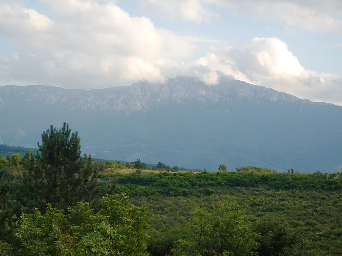
The "Dry Mountain", a monumental, razor-sharp limestone ridge extending for 45 km rising dramatically above the Niš basin.
It is called the "Dry Mountain", and the name is literal: at high elevations, springs are practically non-existent. Jovan Cvijić dubbed it the "Alps of Southern Serbia": a sheer limestone crest 45 kilometres long and up to 15 wide, beginning at Niška Banja, some twenty kilometres from the centre of Niš, and terminating in the Lužnica basin, spanning an elevation gain from 250 to 1810 metres.
Today it constitutes the Suva Planina Special Nature Reserve, designated in 2015 and covering 181 square kilometres.
What makes it unique
Two Tertiary relict plants, Ramonda serbica and Ramonda nathaliae, thrive here alongside feral horses that roam above 1600 metres.
The place
Nature
The landscape
The highest summits are Trem (1810 m), Golemo Stražište (1714), Litica (1683), Sokolov Kamen (1523), and Mosor (984). The knife-edge ridge separates the Sićevo gorge to the northeast from Zaplanje to the west. The massif exhibits extraordinary karst topography and forms an exceptional sedimentary archive rich in fossil flora and fauna; the Valožje plateau is recognized as an outstanding high-mountain karst landscape.
Deciduous forests are dominated by oak and beech, with the coniferous belt tapering off into dwarf mountain pine. The exposed topography keeps some pastures wind-scoured even during harsh winters when blizzards pile deep drifts. Because surface water is scarce, the few permanent springs become vital gathering points: the two largest are Bojanine Vode, nestled beneath Sokolov Kamen at 860 metres, and Rakoš Česma on the Bela Palanka flank, where a small pond serves as a watering hole for semi-feral horses.
Wildlife and seasons
The mountain is a botanical garden. Over 1200 plant species grow here, 128 of which are regional endemics; the 1.261 species inventoried up to 2015 represent a full third of Serbia's flora. Endemics include Pančić's columbine and Serbian rose. In the alpine belt around 1.400 metres, Dryas octopetala, Androsace villosa, and Gentiana verna flourish on rocky ledges.
Fauna includes great crested newt, Hermann's tortoise, nose-horned viper, golden eagle, European snow vole, grey wolf, roe deer, and wild boar. More than 139 bird species, 25 mammals, 13 reptiles, 259 insects, and 86 butterflies inhabit the reserve. The reserve management plan highlights Egyptian vulture, golden eagle, short-toed snake eagle, long-legged buzzard, levant sparrowhawk, and peregrine falcon among the avifauna of the strictly protected core zone.
Horses are the year-round icons of the plateau. The herds from Divna Gorica range into the highest zones above 1600 m. For generations, local villagers stabled livestock in winter and released them in spring; today hundreds of cattle and semi-feral horses graze freely across the ridges during the warm season until early November. On the last weekend of February, the annual "Winter Climb to Trem" convenes over 600 mountaineers from across the Balkans.
Species
With a page in the atlas
Being mentioned in a source doesn't guarantee sightings: check with the people who manage the area.
Memory and protection
History and conservation
Human history runs deep here. Pešturina cave in the north has yielded Middle and Upper Paleolithic stone tools since 2006, and in April 2019 archaeologists announced the discovery of the first confirmed Neanderthal remains in Serbia. From the heights, remnants of the Roman military highway Via Militaris connecting Singidunum with Constantinople can still be traced across the plains below.
The reserve zoning organizes the mountain into three conservation regimes. The first and strictest tier covers near-pristine crests, stretching from Mount Mosor across Sokolov Kamen, Trem, Točila, and Smrdan to Ržanca and Divna Gorica; the second includes the Valožje karst basin, Golemo Stražište peak, and the Rubovac-Cerje enclave. The mountain is also incorporated into the European Emerald network and recognized as an Important Bird Area, Important Plant Area, and Prime Butterfly Area.
Since the nineteen-seventies the rural population has dwindled, and the massive herds of cattle and sheep have disappeared. In 2021 the mountain's primary high-altitude spring, Rakoš, dried up entirely in August, marking the worst of six severe droughts recorded since 1990 as the mountain becomes progressively drier.
Before you set off
Visiting
How to visit
From Niš, access leads through Niška Banja to the mountain retreat of Bojanine Vode, where hiking trails strike out toward the summits and ridges. There is no public bus service to the site; walking approaches begin in the village of Gornja Studena. Beyond Trem, the highest crest, guided outings tackle Sokolov Kamen, the rocky needle of Mosor, or the full ridge traverse.
Access to the strict nature reserve core is restricted to educational and research visits authorized by the management body, and the management plan proposes developing a visitor centre at the Bojanine Vode mountain lodge. Motorway E-80 linking Niš to the Bulgarian border traverses the northern edge of the reserve planning zone.
Before you go
Carry all the drinking water you will need: natural springs are virtually non-existent at high altitudes and can dry up during arid seasons. Access regulations for the strict protection zone are set by the managing authority.
Check access, rules and visiting conditions in the official information from the managing body before you set off.
Location
Where it is and how far it reaches
Boundary of Suva planiana · IUCN IV · © EEA, CDDA (CC-BY) The coordinate is estimated; it isn't a verified access point.
Transparency
Sources
The research data with its sources, and the official links for this place, are in the Spanish version of this page. See the Spanish version
Around it
Some twenty-five kilometres away lies Stara Planina Nature Park. Among distant counterparts, Els Ports shares Egyptian vulture, wildcat, and peregrine falcon amidst karst mountain relief; Vikos-Aoös shares Egyptian vulture and chamois across high karst walls; while Gorges du Verdon and Hoces del Río Duratón share Egyptian vulture, peregrine falcon, and golden eagle on dramatic limestone canyons.
If you like this place, elsewhere in Europe
Distant places with uncommon wildlife and habitats in common. The most widespread species don't count. Sharing species doesn't imply a corridor or guaranteed presence.
- Els Ports Natural Park
Catalonia / Aragon / Valencian Community (Tarragona / Teruel / Castellón / Roquetes / Tortosa)
In common: Egyptian vulture · Peregrine falcon · European wildcat — high mountain, karst and caves
A rugged karst massif between Catalonia, Aragon, and the Valencian Community featuring limestone cliffs, southern beech groves, and the Iberian ibex.
JFMAMJJASONDApril – June · September – November · Crowding low
- Montsant Natural Park
Catalonia (Province of Tarragona / Priorat comarca)
In common: Egyptian vulture · Peregrine falcon · European wildcat — karst and caves
A range of limestone-conglomerate ramparts, gorges and Mediterranean forest inhabited by Bonelli's eagle and Iberian ibex.
JFMAMJJASONDMarch – June · September – November · Crowding low
- Cijevna River Canyon
Tuzi Municipality / Podgorica
In common: Egyptian vulture · Peregrine falcon · Golden eagle — karst and caves
Narrow miniature canyon carved into pure limestone on the way to Lake Skadar.
JFMAMJJASONDApril – June · September – October · Crowding low
- Verdon Regional Natural Park - Grand Canyon
Alpes-de-Haute-Provence / Var (Castellane / Moustiers-Sainte-Marie)
In common: Egyptian vulture · Peregrine falcon · Golden eagle — karst and caves
The 'Grand Canyon of Europe', sheer limestone cliffs plunging 700 m carved out by the turquoise waters of the Verdon River.
JFMAMJJASONDApril – June · September – October · Crowding moderate
Entry #325 of the original atlas.