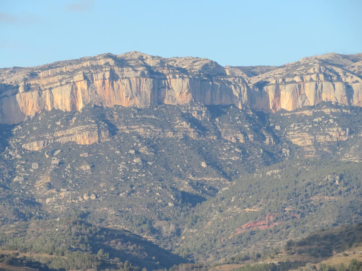
Montsant Natural Park
Parc Natural de la Serra de Montsant
Catalonia (Province of Tarragona / Priorat comarca) · Spain
Photo: Juan Emilio Prades Bel · CC BY 4.0 · Wikimedia Commons
A range of limestone-conglomerate ramparts, gorges and Mediterranean forest inhabited by Bonelli's eagle and Iberian ibex.
Montsant means holy mountain, and one glance explains why. It rises as an abrupt block, with a nearly bare conglomerate ridge, surrounded by eleven villages of the Priorat that make it look like an island of biodiversity. The Carthusians founded at its foot, in 1194, the first Carthusian monastery of the Iberian Peninsula, Santa Maria d'Escaladei, and hermitages still stand in spectacular enclave sites inside. The natural park, designated in 2002, protects its geological, biological, landscape and cultural values.
What makes it unique
A conglomerate wall accessible only via rock passages called grades, surrounded by hermitages, dry stone and raptors.
The place
Nature
The landscape
The sierra is a body of conglomerates that form cingles on the main ridge, the Serra Major, and of marls that give rise to numerous rock shelters and caves. The rock is the work of differential erosion: wind and water act on calcareous materials and softer layers between them, and karstification does the rest. Roca Corbatera, at 1,163 m, is the highest summit.
Although it looks inaccessible, people long ago discovered the grades: passages with steep gradients, with or without fixed equipment, that allow you to overcome the cliffs and reach the Serra Major. From La Morera de Montsant, where the park headquarters is, several start, of different difficulty.
One of the most singular spots is the Fraguerau gorge, where the Montsant river forces its way between rounded rocks with popular names like the Tres Jurados or the Roca Bailadora. Its name comes from Fra Guerau, a hermit who lived in a cave next to which the Romanesque chapel of Sant Bartomeu stands. At the heart of the sierra there is also a circular karstic depression, surrounded by conglomerate walls, that usually holds water all year and preserves the drinking troughs that shepherds prepared for their flocks.
The vegetation changes with moisture. In dry areas garrigues and scrub with Aleppo pine dominate; at the top, in humid spots, stands of downy oak appear. The cliffs have varied rupicoline vegetation, and along the Montsant river a gallery forest of poplars, ashes and willows grows. The valleys of the Montsant and the Siurana surround the massif and act as biological corridors.
Wildlife and seasons
Bonelli's eagle, the peregrine falcon, the common kestrel, the golden eagle, the eagle owl, the goshawk and the long-eared owl nest and rest in Montsant. The park works with special habitat measures for Bonelli's eagle to ensure its survival. On the cliffs the griffon vulture nests, and in recent years the Egyptian vulture has been detected. To protect the breeding of these raptors, climbing is regulated: there are free zones, zones restricted from 15 July to 31 December, and prohibited zones.
Among the mammals stand out the greater horseshoe bat, the wild cat and the otter, which has returned in recent years and has already recolonised much of the river. The Iberian ibex maintains a stable population of about 200 individuals, according to data from 2022. Among the amphibians the fire salamander and the natterjack toad stand out, and in the most hidden corners of the river the increasingly scarce Iberian crayfish still lives. The barbel and the Iberian chub inhabit the water.
Since 2005 the park has been releasing Hermann's tortoises to repopulate the territory. It already lived in Montsant in the Neolithic, and by 2021 a total of 6,289 individuals had been released. The Montsant grasshopper is an endemic species of Montsant and the Serra de la Llena.
In winter and early spring many weed species flower, and the park recommends that season for flora routes.
Species
With a page in the atlas
Being mentioned in a source doesn't guarantee sightings: check with the people who manage the area.
Memory and protection
History and conservation
The sierra entered the Plan of Natural Areas of Interest of Catalonia in 1992, ten years before becoming a park. Almost all of its area, 93.38 %, is privately owned. In 2018 the park and twelve surrounding municipalities were declared a quiet and quality night-sky zone, and in 2021 it obtained the Starlight certification. The Tejo de la Cueva in Margalef is about 1,200 years old and is the yew with the widest canopy measured in Catalonia.
Before you set off
Visiting
How to visit
The Albarca flora route starts beside the village entrance, at the turn-off from the C-242 road, and takes forty-five minutes. It crosses the transition zone from the sunny holm-oak woodland to the Valencian oak woodland in the shaded slopes. For a full day there is the Clot del Cirer, a circular route of 9 km with 600 m of positive elevation gain and moderate difficulty. The Cartujanos Route also allows you to complete the Montsant traverse and learn about the Carthusian history.
In the Montalts area, between La Vilella Baixa and Cabacés, there is a circular route suitable for all abilities that interprets dry stone walls, with terraces, shelters, cisterns and Civil War trenches.
Before you go
Climbing is regulated: before opening a route or climbing in a restricted zone, consult the park. Almost all the territory is private land, so respect crops and neighbours.
Check access, rules and visiting conditions in the official information from the managing body before you set off.
Location
Where it is and how far it reaches
Boundary of Serra del Montsant · IUCN V · © EEA, CDDA (CC-BY) The coordinate is estimated; it isn't a verified access point.
Transparency
Sources
The research data with its sources, and the official links for this place, are in the Spanish version of this page. See the Spanish version
Around it
Montsant shares raptors and rock faces with distant places in the atlas. Sierra de las Nieves National Park also has Bonelli's eagle, Iberian ibex and griffon vulture on karstic terrain; at Picos de Europa National Park the ibex and griffon vulture coincide, and in Lo Zingaro Nature Reserve the Bonelli's eagle and peregrine falcon live on limestone cliffs.
If you like this place, elsewhere in Europe
Distant places with uncommon wildlife and habitats in common. The most widespread species don't count. Sharing species doesn't imply a corridor or guaranteed presence.
- Sierra de las Nieves National Park
Andalusia (Málaga — Ronda / Tolox / Yunquera)
In common: Bonelli's eagle · Spanish ibex · Griffon vulture — karst and caves
Spanish fir forests (pinsapares), a relict conifer growing only in these ranges, over deep karst harboring some of the deepest chasms in Spain.
JFMAMJJASONDMarch – May · October – December · Crowding low
- Gerês-Xurés Transboundary Biosphere Reserve
Northern Portugal (Viana do Castelo / Braga / Vila Real) (PT) / Galicia (Ourense / Lobios) (ES)
In common: Spanish ibex · Greater horseshoe bat · Eurasian eagle-owl — karst and caves, old-growth forest
Portugal's sole National Park joined with Galicia's Serra do Xurés Natural Park, forming a transboundary reserve of granite monoliths and herds of free-roaming Garrano horses.
JFMAMJJASONDMay – October · Crowding low
- Verdon Regional Natural Park - Grand Canyon
Alpes-de-Haute-Provence / Var (Castellane / Moustiers-Sainte-Marie)
In common: Egyptian vulture · Griffon vulture · Eurasian eagle-owl — karst and caves, gorge and canyon
The 'Grand Canyon of Europe', sheer limestone cliffs plunging 700 m carved out by the turquoise waters of the Verdon River.
JFMAMJJASONDApril – June · September – October · Crowding moderate
- Hoces del Río Duratón Natural Park
Castile and León (Segovia / Sepúlveda / Sebastopol / San Frutos)
In common: Egyptian vulture · Griffon vulture · Eurasian eagle-owl — karst and caves, gorge and canyon
Incised meanders 100 m deep carved into red limestone by the Duratón River, featuring the renowned cliffside hermitage of San Frutos.
JFMAMJJASONDApril – June · September – October · Crowding moderate
Entry #504 of the original atlas.