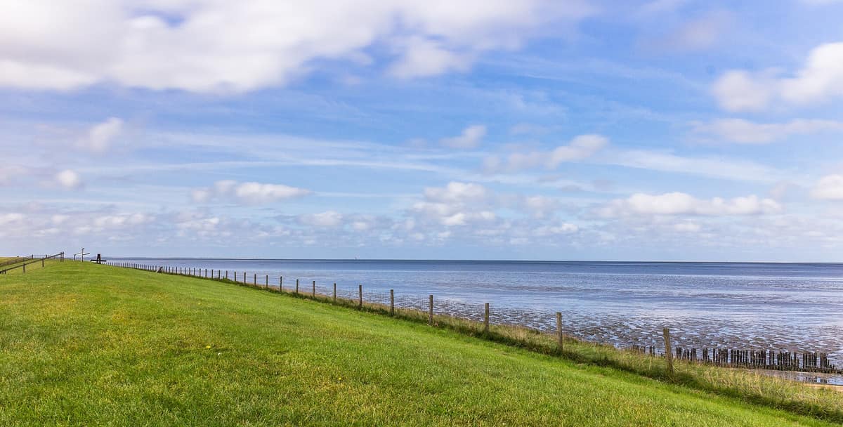
Wadden Sea Salt Marshes (Dutch Sector)
Waddenzee - Kwelders en Salzwiesen (UNESCO World Heritage)
Provinces of Friesland and Groningen (Islands of Texel, Vlieland, Terschelling, Ameland, Schiermonnikoog, and mainland coast) · Netherlands
Photo: Famberhorst · CC BY-SA 4.0 · Wikimedia Commons
Vast intertidal system of mudflats and salt marshes, a vital lifeline for millions of migratory birds along the Atlantic flyway.
Twice a day the tide withdraws, uncovering the floor of an ocean. This is no beach: it is a plain of silt and sand that stretches to the horizon, grooved by deep gulleys, with sandbanks where seals rest and, landward, fringes of salt-tolerant grasses that are inundated only on the highest spring tides. Those fringes are the salt marshes, the kwelders, and they are the prime reason this Dutch sector of the Wadden Sea—between the Marsdiep off Den Helder and the Dollard in Groningen—belongs to the UNESCO World Heritage list. The Wadden Sea (Waddenzee) is the world's largest unbroken expanse of intertidal sand and mud flats, and the trilateral UNESCO property encompasses 1,143,403 hectares across three nations.
What makes it unique
Twice every day the seabed emerges into the open air, and you are permitted to walk across it.
The place
Nature
The landscape
All of this is geologically young. Around 8000 years ago, postglacial sea level rise began to decelerate, allowing the Wadden Sea to form: an outer barrier chain of dune islands and shoals, shielding intertidal flats and salt marshes behind them. The Frisian barrier islands represent the eroded remains of ancient coastal dunes, and they are constantly in motion. Vlieland and Ameland have drifted eastward over the centuries, losing land on their western shores while gaining ground to the east.
Wind joins with the tide to govern the waters. Fierce westerly gales push sea levels up to 4 m above normal, submerging the tidal flats for days; strong easterlies blow the low tide out further than usual, drying shoals that normally remain submerged and stranding interisland ferries in port. As a result, the coastline shifts day by day.
Salt marshes are born of silt. Each flood tide deposits fine mud onto the flats; the ground gradually builds above daily high water and becomes colonized by halophytic plants that trap sediments and anchor the land. Glasswort (zeekraal), sea lavender (lamsoor), common cordgrass (Engels slijkgras), and sea blite (schorrenkruid) establish successively. Plant diversity increases steadily from the lower pioneer zone, inundated regularly, up to the high marsh, flooded only in storms. Because every flood deposits fresh silt, the salt marsh accretes upward, keeping pace with sea level rise.
Wildlife and seasons
The Wadden Sea shelters roughly 10,000 species of flora and fauna, including about 2700 of marine origin. In the salt marshes alone, some 2,300 species occur. It constitutes one of the premier staging grounds for shorebirds worldwide: over a quarter of the European populations of Eurasian spoonbill, pied avocet, gull-billed tern, and Sandwich tern nest in the Wadden Sea. Nearly the entire population of dark-bellied brent goose and red knot from Europe and western Russia depends on these mudflats. In late summer, nearly all common shelduck from northern and western Europe congregate in undisturbed sanctuaries here to undergo their annual wing moult.
Every season brings a distinct wave of life. Between ten and twelve million migratory birds traverse the World Heritage property in an average year, with up to 6.1 million present simultaneously at peak stopover. From the Groningen dike you can watch thousands of waders foraging across the mudflats and Dollard margins. Salt marshes host nesting colonies of common terns, redshanks, avocets, and ringed plovers; open beaches shelter the Kentish plover and little tern, both Red List species whose choice of breeding habitat coincides with high-recreation beaches.
Seals embody an inspiring conservation recovery. Heavily hunted until the mid-twentieth century, their numbers plunged below 4000 common seal and almost no grey seal. Today the Wadden Sea harbors roughly 20 % of the Northeast Atlantic common seal population, estimated at some 40,000 animals in 2018, while the largest breeding colony of grey seals in the entire Wadden Sea breeds west of Terschelling. In the Dutch sector, more than a quarter of all common seals gather during their summer moult. The common porpoise also frequents these shallow tidal waters. The phocine distemper virus epidemic dealt a severe blow to populations in 1988, despite prior statutory protection.
Species
With a page in the atlas
Being mentioned in a source doesn't guarantee sightings: check with the people who manage the area.
Memory and protection
History and conservation
In 1932, vast meadows of common eelgrass covered more than 150 km²; today they have largely vanished, with ongoing restoration efforts replanting beds by seed. In 2005, mechanized cockle dredging was outlawed across the Dutch Wadden Sea, and benthic bottom trawling is similarly restricted.
The Dutch and German Wadden Sea was inscribed on the UNESCO World Heritage list on 26 June 2009, with the Danish sector added on 23 June 2014. Most of the Dutch sector enjoys protected natural monument and biosphere reserve status, incorporating Schiermonnikoog, Lauwersmeer, and Dunes of Texel National Parks. While tourism and water sports exert pressure on vulnerable wildlife, they also cultivate public appreciation for the conservation stakes.
Conservation organisations
Before you set off
Visiting
How to visit
The definitive experience here is walking across the exposed seabed at low tide: wadlopen. It must always be undertaken accompanied by a certified mudflat guide, who navigates safe routes without disturbing roosting birds. Deep tidal gullies, soft mud patches, and incoming tides can swiftly cut off unwary walkers. On suitable tides, guided expeditions trek from the mainland all the way to Schiermonnikoog.
The mainland coast of Groningen offers serene alternatives. The outer spit of Punt van Reide, an important seal nursery, overlooks nesting terns, redshanks, avocets, and plovers. The Kiekkaaste hide near Nieuwe Statenzijl commands views over feeding mudflats where porpoises occasionally surface offshore. At Lauwersoog, the Dark Sky Park invites visitors to stargaze, seek nocturnal bats, or cycle along the "darkest cycle path" in the Netherlands.
The five Dutch Wadden Islands—Texel, Vlieland, Terschelling, Ameland, and Schiermonnikoog—are renowned as the "five pearls" of the north, threaded by over 300 km of designated cycle paths; the LF10 Waddenzeeroute traces the mainland shore. The Afsluitdijk Wadden Sea Center serves as the primary UNESCO gateway on the Dutch coast, and visitor centers across the provinces offer field trips into the natural and cultural heritage of the Wad.
Before you go
Maintain ample distance from resting seals and roosting flocks, follow marked paths, pack out all litter, and keep dogs on a leash. Tides and wind conditions are unpredictable: mudflat walking should always be done with a licensed guide, never independently.
Check access, rules and visiting conditions in the official information from the managing body before you set off.
Location
Where it is and how far it reaches
Boundary of Waddenzee · IUCN IV · © EEA, CDDA (CC-BY) The coordinate is estimated; it isn't a verified access point.
Transparency
Sources
The research data with its sources, and the official links for this place, are in the Spanish version of this page. See the Spanish version
Around it
The Lower Saxony Wadden Sea National Park continues the unbroken tidal system across the German frontier, while Lauwersmeer National Park lies some two kilometres inland. Farther away, the Schleswig-Holstein Wadden Sea National Park and Wadden Sea National Park (Denmark) share salt marshes, marine seals, and flyway avifauna.
What else to explore nearby
Approximate straight-line distance between the edges of each area. It doesn't indicate access, routes or driving times.
- Lower Saxony Wadden Sea National Park
Lower Saxony (East Frisian Islands / Cuxhaven / Wilhelmshaven)
About 4 km away
Barrier islands, salt marshes and intertidal mudflats between the Ems and the Elbe, part of the Wadden Sea World Heritage site.
JFMAMJJASONDApril – May · August – October · Crowding moderate
If you like this place, elsewhere in Europe
Distant places with uncommon wildlife and habitats in common. The most widespread species don't count. Sharing species doesn't imply a corridor or guaranteed presence.
- Schleswig-Holstein Wadden Sea National Park
Schleswig-Holstein (Sylt / Halligen / Husum / Tönning)
In common: Common seal · Red knot · Common porpoise — wetland, wild coast
Central Europe's largest national park: intertidal mudflats, dyked islets (Halligen) and millions of migratory waders on passage.
JFMAMJJASONDApril – May · August – October · Crowding moderate
- Wadden Sea National Park (Denmark)
South Jutland (Esbjerg / Fanø / Rømø / Ribe)
In common: Red knot · Grey seal — wetland, wild coast
The world's largest unbroken system of intertidal sand and mud flats (UNESCO World Heritage), renowned for massive starling murmurations (Sort Sol).
JFMAMJJASONDApril – May · September – October · Crowding low
- Great Blasket Island / An Blascaod Mór
Ireland (County Kerry / Dingle Peninsula / Dunquin)
In common: Common porpoise · Grey seal — wild coast
The largest of the Blasket archipelago islands (evacuated in 1953), famed for rich Gaelic literature, wild sea cliffs, and beaches with hundreds of grey seals.
JFMAMJJASONDMay – September · Crowding low
Entry #193 of the original atlas.