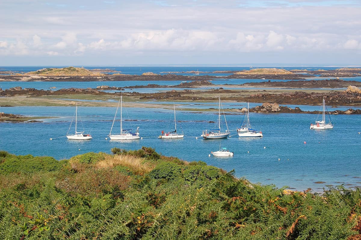
Chausey Archipelago
Archipel de Chausey
Normandy (Manche / Granville) · France
Photo: Pline · CC BY-SA 3.0 · Wikimedia Commons
Europe's largest insular archipelago by tidal range (52 islets at high tide expanding to 365 at low tide).
At high tide, Chausey appears as a scattered cluster of granite islets; at low water, an immense labyrinth of reefs extends to the horizon. Local tradition summarizes this metamorphosis in two numbers: 52 islands at high tide, matching the weeks of the year, and 365 at low tide, matching the days. In reality, the archipelago, lying 16 km off the Norman coast opposite Granville, comprises around twenty main islands and over 130 rocky islets, yet at peak flood tide it totals barely 65 hectares of dry land. Everything else is receding sea, exposed reefs, sandflats, and a maritime ecosystem governed by tidal amplitudes that rank among the most powerful in Europe.
What makes it unique
Chausey is the sole breeding colony in France for the red-breasted merganser, across an archipelago where tidal fluctuations reach up to 14 metres.
The place
Nature
The landscape
Everything here is granite. The islands constitute an exposed granitic pluton, part of the ancient Mancellian batholith, with the granite rocks crystallizing around 540 million years ago. For centuries they served as an offshore stone quarry: the Benedictine monks of Mont-Saint-Michel are regarded as the first quarrymen, potentially beginning in the eleventh century, providing granite used in building Mont-Saint-Michel itself. During the nineteenth century nearly 500 quarrymen laboured across 37 islets, leaving behind the ruins of their historic stone cottages.
Grande Île is the primary island, measuring roughly 1.5 km by 0.5 km. In morphological terms it consists of three granite knolls bound together by a tombolo, rising to a high point of 24 m. Its sandy walking tracks are flanked by maritime gorse and blackthorn scrub. Private cars are prohibited: only a handful of farm tractors and municipal utility vehicles operate. In winter, barely a dozen permanent residents inhabit the island.
At low spring tide, the exposed reef and sand platform forms an ellipse measuring 10 by 5 kilometres. Beneath the waves, Chausey shelters extraordinary meadows of common eelgrass (Zostera marina), a flowering marine seagrass.
Wildlife and seasons
More than 200 bird species frequent the archipelago throughout the seasons. The bird reserve, established in 1987, records 243 species, including mergansers, cormorants, common shelducks, terns, and gulls. At low water, wintering Eurasian oystercatchers account for over 15% of the total French population; at high tide, common gulls, great cormorants, and European shags crowd exposed roosts.
In the surrounding waters, the common bottlenose dolphin is the most frequently observed marine mammal, particularly along the ferry crossing between Granville and Grande Île. Every year since 1984, ornithologists from the Groupe Ornithologique Normand census the breeding birds during an annual survey at Ascension.
Species
With a page in the atlas
Being mentioned in a source doesn't guarantee sightings: check with the people who manage the area.
Memory and protection
History and conservation
In 1022 the Duke of Normandy granted the archipelago to the monks of Mont-Saint-Michel, who established a priory on Grande Île. Chausey remained the only Norman island group retained under French sovereignty following the Treaty of Brétigny in 1360. From the seventeenth century onwards, kelp gathering flourished, burning seaweed into soda ash for regional soap and glass manufacture, while in the nineteenth century pioneering naturalists arrived to document its intertidal biodiversity.
In May 1988 the archipelago was classified as a Special Protection Area (SPA), the first in Normandy. The 2009 management plan safeguards both terrestrial and marine biotopes. Tourism pressures continue to rise, with shore anglers and day-trippers arriving via ferries, sailing yachts, and motorboats.
Before you set off
Visiting
How to visit
Grande Île is accessible year-round along marked coastal paths; the fragile sensitive dunes of the Tombolo and Gros Mont are closed to public access. Passenger ferry shuttles between Granville and the island operate two crossings weekly in winter, expanding to more than ten daily sailings during peak summer. The Conservatoire du Littoral provides a downloadable walking guide on its reserve portal.
Key heritage landmarks include the stone cromlech of l'Œillet, the Pierre du Sacrifice dolmen, and the historic granite lighthouse, built in 1847 and standing 37 m high. The earliest human traces date back to the Neolithic, with the cromlech standing above the northern marshes of the Sound.
Grande Île features no hotels; small seasonal gîtes and seasonal boat moorings serve arriving yachts.
Before you go
Access to satellite islets is restricted during the nesting season to protect ground-nesting seabirds. On Grande Île, remain on waymarked paths and respect the tranquility of residents and wildlife.
Check access, rules and visiting conditions in the official information from the managing body before you set off.
Location
Where it is and how far it reaches
Boundary of Iles chausey · IUCN IV · © EEA, CDDA (CC-BY) The coordinate is estimated; it isn't a verified access point.
Transparency
Sources
The research data with its sources, and the official links for this place, are in the Spanish version of this page. See the Spanish version
Around it
Galicia Atlantic Islands Maritime-Terrestrial National Park shares bottlenose dolphins, coastal seascapes, and open waters with Chausey. Great Blasket Island, Lundy, and Lunga (Treshnish Isles) share the grey seal and marine coastal biotopes.
If you like this place, elsewhere in Europe
Distant places with uncommon wildlife and habitats in common. The most widespread species don't count. Sharing species doesn't imply a corridor or guaranteed presence.
- Atlantic Islands of Galicia National Park
Galicia (Cíes / Ons / Sálvora / Cortegada)
In common: Common bottlenose dolphin — wild coast, marine
Four granitic archipelagos guarding the mouth of the Rías Baixas, with seabird nesting cliffs facing west and sheltered sand dunes facing east.
JFMAMJJASONDApril – June · September – October · Crowding high
- Great Blasket Island / An Blascaod Mór
Ireland (County Kerry / Dingle Peninsula / Dunquin)
In common: Grey seal — wild coast, marine
The largest of the Blasket archipelago islands (evacuated in 1953), famed for rich Gaelic literature, wild sea cliffs, and beaches with hundreds of grey seals.
JFMAMJJASONDMay – September · Crowding low
- Lundy Island
England (Devon / Bristol Channel / Ilfracombe)
In common: Grey seal — wild coast, marine
Granite plateau 5 km in length in the Bristol Channel, the first designated Marine Conservation Zone in the United Kingdom.
JFMAMJJASONDMay – September · Crowding low
- Isle of Lunga (Treshnish Isles)
Scotland (Inner Hebrides / Isle of Mull)
In common: Grey seal — wild coast, marine
Small basalt islet where puffins nest mere inches from walkers’ boots showing virtually no fear of humans.
JFMAMJJASONDMay – August · Crowding low
Entry #629 of the original atlas.