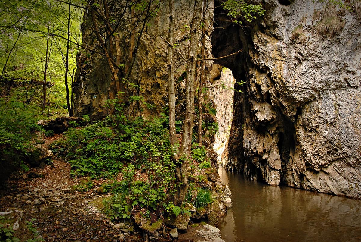
Râmeț Gorge
Cheile Râmețului
Alba County (Trascău Mountains / Teiuș) · Romania
Photo: Rheaxnaidoo · CC BY-SA 3.0 · Wikimedia Commons
Extremely narrow limestone gorge in the Trascău Mountains where the trail runs squeezed between rock walls, crossing the river on foot.
For nearly a kilometre, the only way forward in Cheile Râmețului is in the water. The limestone walls close in, the Geoagiu River fills the gorge floor, and no path remains: you advance through the riverbed. It is a reserve of barely 150 hectares in the eastern Trascău Mountains, and everything within it is compressed: rock, water, and a flora where alpine and thermophilous species live side by side.
What makes it unique
A limestone gorge where, for nearly a kilometre, the only way forward is through the river water.
The place
Nature
The landscape
The gorge lies in the east-central part of the Trascău Mountains, in the middle course of the Geoagiu valley: Valea Mănăstirii downstream, Valea Mogoșului upstream. They are two massifs carved into Jurassic limestones, and the reserve ranges from 530 to 1189 metres in altitude.
The limestone has undergone intense dissolution, yielding a rich karst catalogue: steep and bare slopes, sharp tower-like peaks, crests, sinkholes, caves, natural portals, and gullies, along with screes and boulders. Forests, meadows, and hayfields encircle the rock. Inside the massif, underground water circulation predominates; only the Geoagiu stream, also called Mănăstirea, cuts through the gorge. Surrounding the protected area is a buffer zone of about 300 metres, mostly made up of bordering forest.
The climate is cool: 6 to 8 °C annual average, 16 to 18 °C in July, and between –3 and –4 °C in January. Annual rainfall is between 700 and 800 mm, exceeding 1,000 mm in the high areas.
Wildlife and seasons
The vegetation belongs to the mixed beech and sessile oak forest zone. Within the gorge, alpine species such as Ranunculus oreophilus, Arabis alpina, and Saxifraga paniculata cohabit with thermophiles such as Silene bupleuroides and Linum flavum. There are also endemics, including Dianthus kitaibelii ssp. spiculifolius, Silene dubia, Aconitum moldaicum, and Hepatica transsilvanica. Among rare and protected species are yew, the cranesbill Geranium macrorrhizum, and lady's slipper orchid, Cypripedium calceolus.
The setting invites you to listen to bird song echoing between the rushing water and the gorge canopy, and the municipal strategy of Alba Iulia mentions the golden eagle in Cheile Râmețului.
Species
With a page in the atlas
Being mentioned in a source doesn't guarantee sightings: check with the people who manage the area.
Memory and protection
History and conservation
The reserve was established in 1969 by a decision of the Alba County People's Council, and today it is a protected area of national interest under IUCN Category IV, of mixed type. The official description depicts it as a picturesque landscape very little altered by human activity, sculpted in limestone, preserving rare plants.
The Trascău Mountains harbour other well-known gorges, including Turzii, Turenilor, Găldiței, Întregaldelor, Cetii, Aiudului, and Ampoiței.
Before you set off
Visiting
How to visit
A marked tourist trail traverses the gorge, from the monastery to the hamlet of Cheia. Access is via the DC 73 from Teiuș towards Râmeț Monastery, or via the DJ 107 from Aiud to Brădești, in the commune of Râmeț. Entering is very demanding: for nearly a kilometre you can only advance through the river water.
Râmeț Monastery, 34 km from Alba Iulia and 18 from Teiuș, stands at the entrance to the gorge. It is one of the oldest monastic settlements in Transylvania, and the third layer of frescoes inside was painted by Mihu of Crișul Alb in 1377.
Before you go
The section along the riverbed forces you into the water. For safety, the Salvamont Alba public rescue service is listed as the regional contact.
Check access, rules and visiting conditions in the official information from the managing body before you set off.
Location
Where it is and how far it reaches
Boundary of Cheile Râmețului · IUCN IV · © EEA, CDDA (CC-BY) The coordinate is estimated; it isn't a verified access point.
Transparency
Sources
The research data with its sources, and the official links for this place, are in the Spanish version of this page. See the Spanish version
If you like this place, elsewhere in Europe
Distant places with uncommon wildlife and habitats in common. The most widespread species don't count. Sharing species doesn't imply a corridor or guaranteed presence.
- Fuentes del Narcea, Degaña and Ibias Natural Park and Muniellos Reserve
Asturias (Cangas del Narcea / Degaña / San Antolín de Ibias)
In common: Quercus petraea · Fagus sylvatica
The largest sessile oak (Quercus petraea) forest in Spain and one of the best preserved in Europe (Muniellos).
JFMAMJJASONDMay – November · Crowding very low
- Abruzzo, Lazio and Molise National Park
Abruzzo, Lazio and Molise regions (L'Aquila, Frosinone and Isernia provinces)
In common: Taxus baccata · Cypripedium calceolus — karst and caves
Sanctuary of the Marsican brown bear and Apennine wolf in primeval beechwoods and high alpine valleys of central Italy.
JFMAMJJASONDMay – June · October · Crowding moderate
- Aigüestortes and Lake Saint Maurici National Park
Catalonia (Lleida)
In common: Fagus sylvatica · Sea trout · Golden eagle
The only National Park in Catalonia, a glacial circus wonderland harboring over 200 tarns (estanys) beneath the iconic twin summits of Els Encantats.
JFMAMJJASONDJune – October · Crowding moderate
- Maritime Alps Natural Park
Piedmont (Cuneo / Valdieri / Entracque)
In common: Fagus sylvatica · Sea trout · Golden eagle
United with France's Mercantour National Park, it forms a massive cross-border Alpine-Mediterranean wilderness crowned by Mount Argentera (3.297 m).
JFMAMJJASONDJune – October · Crowding low
Entry #391 of the original atlas.