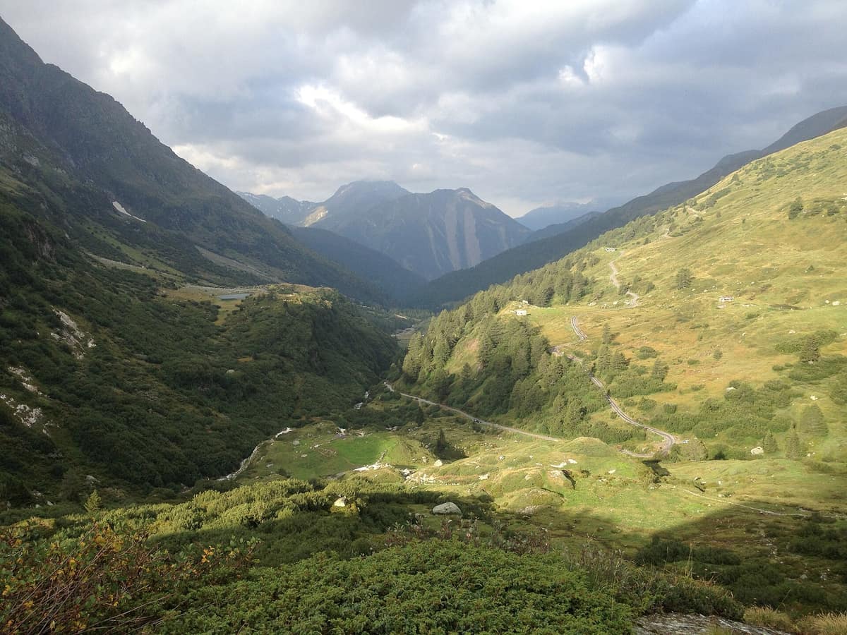
Binntal Nature Park
Landschaftspark Binntal
Valais (Binn / Ernen) · Switzerland
Photo: Tnt66 · CC BY-SA 3.0 · Wikimedia Commons
Alpine valley in Valais world-renowned for its extraordinary diversity of rare minerals.
In the Binntal, crystals are searched for with as much patience as mountain blooms are admired. This alpine valley in Valais is famed for its minerals, yet it is also a botanical hotspot and a haven of remarkable wildlife. Across the Binntal and adjoining deposits over three hundred mineral species have been discovered. Spanning the valley is a regional nature park stretching from around 1000 m up to perpetual snows, culminating at the Helsenhorn at 3,272 m.
What makes it unique
In a single valley more than three hundred mineral species have been found, and in the Lengenbach quarry over 150, of which more than forty were discovered there for the first time.
The place
Nature
The landscape
The valley is a tapestry of contrasts. Sun-drenched rocky slopes face north-facing slopes mantled in dense, moist forest. The topography is exceptionally multifaceted: valleys radiating in all directions from 900 m dominated by peaks rising to 3,250 m, with passes opening into distinct floral realms. There are fens, dry pastures, spruce forests, alpine meadows, glacial forelands, pine woods, tarns, rocky steppes and alpine floodplains.
Beneath your boots the bedrock tells the story. Lengenbach is a steep side glen rising behind the hamlet of Fäld, exposing a band of white dolomitic marble about 300 m across. In these rocks, laid down some 240 million years ago, ores of iron, lead, zinc and other metals precipitated, subsequently metamorphosed during the alpine orogeny in an extraordinary manner. This process gave birth to exotic and rare minerals. Fifty-six minerals claim the Binntal as their type locality.
Wildlife and seasons
Flora erupts the moment warm days arrive. In May the Grengiols tulip blooms, found nowhere else on Earth, and early summer brings a profusion of alpine lilies, martagon lilies, gold-cushion primroses and milkvetches. The tulip survives because since 1996 a local association has maintained traditional rye cultivation, ensuring its strict protection. To the south, on gneiss bedrock, extensive stands of alpenrose and Swiss willow carpet the tree line. In the protected mire of the Albrun Pass thrive bog cottongrasses, least rush and two arctic relict rushes. The Binntal flora also features plumeless knapweed, yellow rockrose and the stemless milkvetch, a rare speciality.
Wildlife follows its own rhythm. In spring, emerging from hibernation, the asp viper is highly active, basking in the sun; the Binntal is a known stronghold. The apollo butterfly, extinct or declining in other European countries, is still regularly seen across dry south-facing slopes. Crag martins are widespread and nest in mountain villages: in Heiligkreuz and neighbouring hamlets, under eaves and overhangs.
Large mammals roam widely. chamois are adept climbers, seeking steep crags for refuge, especially when tending kids; males only join female herds during the late autumn rut in November and December. A telemetry study revealed that nearly all red deer winter in the Binntal and migrate across the Albrun Pass into Italy each spring, returning in November and December. Consequently, relatively few are seen in summer during the rutting season.
Species
With a page in the atlas
Being mentioned in a source doesn't guarantee sightings: check with the people who manage the area.
Memory and protection
History and conservation
Minerals originally drew travellers here: in the nineteenth century, British visitors first discovered the valley, and in 1883 the historic Hotel Ofenhorn opened. Yet the defining historical artery is older: the historic mule track over the Albrun Pass, at 2,409 m, served as a primary transalpine trade route already in the Iron Age.
Conservation came early. In 1964 the municipality of Binn, Pro Natura Valais and the Swiss Alpine Club signed a pioneering protection agreement for the Binntal, renouncing major hydroelectric expansion, holiday home development and intrusive tourist infrastructure. The area achieved official regional nature park status in 2011. In 2025 the Canton of Valais recognized traditional mineral collecting and study as a living tradition and intangible cultural heritage. The Lengenbach quarry continues to operate exclusively for scientific research.
Before you set off
Visiting
How to visit
To grasp the geology, start with the geological theme trail between Fäld and the Lengenbach mine: eleven stations, 1.25 km, 150 m of ascent and about 30 minutes of walking. To explore further, the park runs guided mineral excursions led by a local crystal hunter (Strahler), alongside tours with regional experts on geology, flora, animal tracks and bird habitats. A botanical walk explores larch pastures shaped by centuries of traditional grazing.
The trail network is color-coded across three difficulty tiers; alpine blue trails cross trackless scree, snowfields, glaciers and exposed scrambling terrain. A 7.92 km circular walk taking 2 h 32 min departs from Ausserbinn, with side trips to the Binna gorge and Roman bridge. The long trek from Binn to the Leng valley traverses Wilere and Heiligkreuz, crossing three torrents and taking 7 h 30 min (20.50 km). Further thematic paths introduce notable trees, such as a 4.88 km route taking 1 h 30 min around Ernen.
The regional museum in Binn presents displays of minerals, traditional farming implements, craft history and archaeological findings.
Before you go
Within the park you must not pick plants, keep disturbance to wildlife minimal, carry out all waste and refrain from camping. Livestock, wildlife, livestock guarding dogs and visitors share this alpine terrain: when encountering a guard dog, do not run, never turn your back or look it in the eye, and dismount from bicycles. Bringing domestic dogs near herds is strongly discouraged; if accompanying you, keep them strictly leashed.
Check access, rules and visiting conditions in the official information from the managing body before you set off.
Location
Where it is and how far it reaches
Boundary of Landschaftspark Binntal · © OpenStreetMap contributors (ODbL) The coordinate is estimated; it isn't a verified access point.
Transparency
Sources
The research data with its sources, and the official links for this place, are in the Spanish version of this page. See the Spanish version
Around it
The Curso Alto del Valle de Lötschental lies about two kilometres away, and Parque Nacional de la Val Grande roughly twenty-one kilometres distant. The Aletschgebiet partially overlaps with this territory.
What else to explore nearby
Approximate straight-line distance between the edges of each area. It doesn't indicate access, routes or driving times.
- Great Aletsch Glacier - Unspoiled Sectors
Valais (Fiesch / Riederalp)
About 3 km away
The largest glacier in the Alps (20 km long) bordered by ancient stone pine and larch stands in the Aletschwald.
JFMAMJJASONDJune – October · Crowding moderate
- Val Grande National Park
Piedmont (Verbania / Lake Maggiore / Malesco / Santa Maria Maggiore)
About 29 km away
The largest wilderness area in the Alps and Italy, an impenetrable canyon valley fully reclaimed by wild nature.
JFMAMJJASONDMay – October · Crowding very low
If you like this place, elsewhere in Europe
Distant places with uncommon wildlife and habitats in common. The most widespread species don't count. Sharing species doesn't imply a corridor or guaranteed presence.
- Northern Velebit National Park
Lika-Senj (Croatia)
In common: Parnassius apollo · Chamois · Golden eagle — high mountain, old-growth forest
Karst relief, ancient beech forests and mountain pastures in Northern Velebit.
JFMAMJJASONDMay – November · Crowding low
- Paklenica National Park - Velebit Plateau
Zadar County (Starigrad-Paklenica)
In common: Parnassius apollo · Chamois · Golden eagle — high mountain, old-growth forest
Vertical incised canyons (Velika and Mala Paklenica) plunging straight towards the Adriatic Sea from the crests of Velebit.
JFMAMJJASONDApril – June · September – October · Crowding low
Entry #337 of the original atlas.