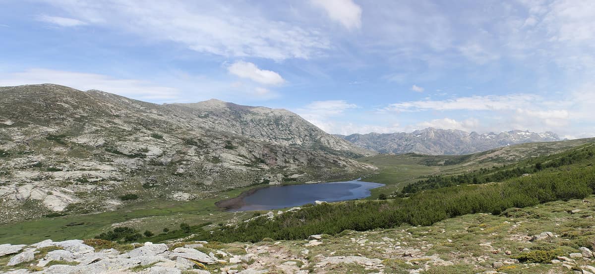
Corsica Regional Nature Park
Parc naturel régional de Corse
Corsica (Corte / Ajaccio / Bastia / Porto) · France
Photo: Arnaud Abadie · CC BY-SA 4.0 · Wikimedia Commons
Covers more than 40 % of the island of Corsica (375,000 ha), encompassing the backbone of Monte Cinto (2,706 m) and the canyons of the Restonica and Tavignano.
In 1969 the last deer of Corsica was shot, in the forest of Pinia. When the regional park was born, mountain villages were emptying, cultivation terraces were filling with maquis and the island was watching its interior die. From that came the idea of a regional park, demanded by Corsica itself: a proactive policy to save the interior. The Corsica Regional Nature Park, the Parcu di Corsica, is built on the great mountain ridge that crosses the island from north-west to south-east and culminates in Monte Cintu (2,706 m); it is above all a rural and mountain park, associating the Collectivité de Corse and 178 municipalities.
What makes it unique
The whole mountain of Corsica, with the GR20 and the other long-distance trails of the island, and with deer and mouflon back in the forests and on the summits.
The place
Nature
The landscape
Beyond the ridge, the park has maritime faces: the grandiose and wild western coast of the Gulf of Porto-Girolata, and a sample of the lagoons of the eastern shoreline. On that western flank, the Falasorma–Dui Sevi biosphere reserve covers the valleys of the Fangu and the Portu and drops some 1,500 metres into the Gulf of Portu down to Punta Minuta at 2,556 m. The Gulf of Porto is classified as a UNESCO World Heritage Site, and the Corte–Ota route ends at Ota with that view between sea and mountains.
Island isolation made the park a laboratory of endemisms, high for Europe: the Corsican nuthatch, the Corsican mouflon, the Corsican trout and Montalent's painted frog; among plants, the Laricio pine and the Corsican garlic. The island's culture stays alive in livestock farming and in the Bronze Age castles of Cucuruzzu and Capula, in the municipality of Livia, reached from the Mare a Mare trail.
Wildlife and seasons
Two animals tell the park's story. The Corsican mouflon lives in two areas, the Cintu massif and the Bavella massif, and the two populations are distinct subspecies according to genetic studies. It is threatened by lamb predation and disturbance from outdoor activities, and since 2020 the park releases animals from the Quenza breeding enclosure to form a new nucleus. If you want to see it, bring binoculars, stay quiet and keep your distance.
The deer came back from Sardinia. In 1985 four animals were reintroduced at the Quenza enclosure; from 1998 to 2017 there were 20 releases with more than 300 deer, and today the population is estimated at between 4,000 and 5,000. The park has set up thematic trails with viewpoints to track them and, with luck, see them.
In the sky there is a reinforcement programme for the bearded vulture, "Altore", coordinated by the park, and an INTERREG project for the osprey. From mid-June to mid-September access to some massifs may be dangerous depending on weather, and they may be closed to the public if severe risk exists.
Species
With a page in the atlas
Being mentioned in a source doesn't guarantee sightings: check with the people who manage the area.
Memory and protection
History and conservation
In 1971 the park charter was approved, focused on protecting nature and renewing the rural economy with livestock and tourism. In 1972 the decree creating it was signed, the GR20 was given its number and the first mouflon reserve was created. Today the park also looks after mountain lakes: it regulates visitor flow, monitors for wild camping and organises waste collection.
Before you set off
Visiting
How to visit
The park is the island's leading hiking operator. The GR20 is the name everyone knows: since 1972 it has carried that number, and the first refuge on the route was built in 1971. It is waymarked with white and red markers. The first stage, from Calenzana to Ortu di u Piobbu, takes six and a half hours: it starts from the San'Antone spring, follows an old mule track to the Ortiventi spring, passes the Arghjova viewpoint at 820 metres and reaches the Ortu di u Piobbu refuge at 1,520 metres.
But there are more trails, all waymarked in orange:
- The Mare è Monti runs from Calenzana to Cargèse in ten days of 4 to 6 h 30 and 121 km, below the summits but close to the sea. It can be done year-round, best in spring and autumn; in summer, start early and carry plenty of water. - The Corte–Ota takes four days, 58 km and 2,500 m of ascent, through Laricio pine forests, the Niolu valley and old transhumance paths. - The Transhumance trail follows the age-old shepherd's path that linked the Niolu mountains with the plain: five days and 72 km, from mid-April to end of October, requiring good fitness. - The Mare a Mare Nord goes from Moriani to Cargèse via Corte in 11 or 12 days and 139 km, at the foot of Monte Cintu and the Paglia Orba. - For something gentler, the Mare è Monti Sud (Porticcio–Propriano, five days, 66 km) or the Mare a Mare Sud (Porto-Vecchio–Propriano, five days, 73 km), suitable for those with little experience and walkable all year.
Before you go
At the park's refuges, overnight booking is compulsory, including for bivouacs and sleeping platforms, and is made through the park's central booking service. Wild camping is prohibited: it is only authorised next to refuges or in designated areas. Dogs are strongly discouraged on this route because of the steep passes and abseil descents, and are not admitted inside the park refuges. Do not walk on the pozzi and pozzines, very sensitive wetlands, and do not feed or disturb wildlife.
Mountain professionals urge you never to go alone, never to stray from waymarked paths, and to be wary of weather changes, because even in summer there are violent storms.
Check access, rules and visiting conditions in the official information from the managing body before you set off.
Location
Where it is and how far it reaches
Boundary of Corse · IUCN V · © EEA, CDDA (CC-BY) The coordinate is estimated; it isn't a verified access point.
Transparency
Sources
The research data with its sources, and the official links for this place, are in the Spanish version of this page. See the Spanish version
How it fits into the territory
Calculated from the Atlas boundaries. «Part of» is only stated with an official boundary; an estimated area only means that they overlap.
Within this area · 1
- Bavella Massif and Needles
Corsica (Zonza / Quenza / Solenzara)
Inside its official boundary
A wall of red granite towers and pinnacles weathered into surreal hollow forms (taffoni), framed by Corsican black pine.
JFMAMJJASONDMay – October · Crowding moderate
Around it
At 19 km, the Parc Naturel Marin du Cap Corse et de l'Agriate is the neighbouring marine park. And sharing a mouflon connection, though far away: the Troodos National Forest Park; sharing the bearded vulture: the Parc Natural dels Ports.
What else to explore nearby
Approximate straight-line distance between the edges of each area. It doesn't indicate access, routes or driving times.
- Cap Corse and Agriate Marine Natural Park
Corsica (Bastia / Saint-Florent / Centuri)
About 19 km away
The largest Marine Natural Park in metropolitan France (6.800 km²), safeguarding the pristine scrubland of the Agriates Desert and the Genoese towers of Cap Corse.
JFMAMJJASONDMay – October · Crowding low
If you like this place, elsewhere in Europe
Distant places with uncommon wildlife and habitats in common. The most widespread species don't count. Sharing species doesn't imply a corridor or guaranteed presence.
- Troodos National Forest Park
Cyprus (Troodos / Platres)
In common: Mouflon — high mountain, old-growth forest
The pine-cloaked peaks of Cyprus, towering above a complete section of ancient oceanic crust lifted from the Tethys seabed.
JFMAMJJASONDApril – June · September – October · Crowding low
- Els Ports Natural Park
Catalonia / Aragon / Valencian Community (Tarragona / Teruel / Castellón / Roquetes / Tortosa)
In common: Bearded vulture — high mountain, gorge and canyon, old-growth forest, karst and caves
A rugged karst massif between Catalonia, Aragon, and the Valencian Community featuring limestone cliffs, southern beech groves, and the Iberian ibex.
JFMAMJJASONDApril – June · September – November · Crowding low
Entry #630 of the original atlas.