Telašćica Nature Park
Park prirode Telašćica
Zadar (Dugi Otok Island) · Croatia
Photo: qwesy qwesy · CC BY 3.0 · Wikimedia Commons
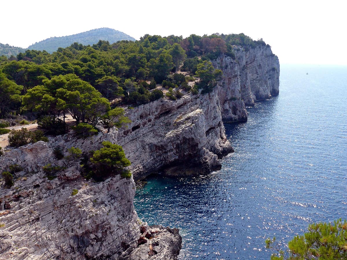
Sea cliffs rising over 150 metres above the open Adriatic and the saltwater Lake Mir, at the southern tip of Dugi Otok.
Look at a map of Dugi Otok and trace its southern extremity: a sheltered bay ten kilometres long that branches into three connected basins, like three natural lakes laid out end to end. This gave rise to its name, Telašćica, documented in medieval records as Tilagus. Considered the safest and largest natural harbour in the Adriatic, its surroundings, protected as a nature park since 1988, encompass sheer sea cliffs, islets, a saltwater lake and shores that are windswept and bare to the north-east while carpeted in Aleppo pines, olive groves and fig trees to the south-west.
What makes it unique
Three natural wonders in a single park: a bay of three joined basins, sea cliffs continuing beneath the waves, and the saltwater Lake Mir.
The place
Nature
The landscape
The nature park encompasses 70.50 km², though only 25.95 km² is dry land across Dugi Otok and adjacent islets; the remaining 44.55 km² is marine reserve. Here the sea takes centre stage. The bay shelters six islets and reefs, including Korotan and Galijola; Katina is the most picturesque, while Taljurić is a curious flat skerry. The highest elevation is Mrzlovica, reaching 198 m, while the bay plunges to depths of 67 m.
The towering cliffs, known locally as the stene, form the emblem of the park. Rising dramatically above the open sea, their vertical faces plunge straight into the submerged abyss. Another hydrological curiosity is Lake Mir, kept saline through subterranean fissures connecting it to the sea.
On land, a Mediterranean climate prevails: over 2,500 hours of sunshine each year, with sea temperatures averaging around 13 degrees in winter and 23 degrees in summer. Summer is dominated by the refreshing maestral breeze, winter by the biting bura, while southerly jugo gales produce the heaviest seas.
Wildlife and seasons
The park harbours roughly 500 terrestrial plant species, while the marine seabed supports over 300 plant species and 300 animal species. Notable rarities include tree spurge (Euphorbia dendroides), which reaches its northernmost European distribution here, and the Dugi Otok knapweed, an endemic rock-clinging specialist restricted strictly to Dugi Otok and Kornati. In late spring and summer, the miniature wild iris Iris adriatica blooms across rocky pastures, followed by Seseli tomentosum in August and September. Flora includes ten strictly protected wild orchid species.
Birdlife is best observed along the coastal precipices. The outer cliffs provide eyries for the peregrine falcon; the rare Eleonora's falcon appears as a wandering visitor from southern breeding islands. On lower sea ledges nests the European shag, while rock screes shelter the eagle owl alongside passerines such as the black-eared wheatear, rock partridge and blue rock thrush. Swifts nest in cliff crevices, including pallid, common and alpine swifts. During spring and autumn migrations, vast numbers of European birds pass through, while winter brings diverse sea ducks. In total, 115 bird species have been recorded, including 15 raptor species of which at least five breed locally.
Nine bat species inhabit the park; the largest colony roosts in Golubinka cave with an underwater sea entrance, sheltering some 2000 Geoffroy's bats and around 1000 greater horseshoe bats. Among 13 reptile species, the endangered loggerhead sea turtle frequents the coastal waters; among amphibians, only the European tree frog and green toad endure the dry summer climate.
Submerged cliff terraces support luxuriant Neptune grass meadows where the long-snouted seahorse finds refuge.
Species
With a page in the atlas
Being mentioned in a source doesn't guarantee sightings: check with the people who manage the area.
Memory and protection
History and conservation
Roman remains survive at Mala Proversa alongside numerous early medieval pre-Romanesque chapels, including Saint John at Stivanje polje. Local folklore tells of the Peteročići of Koženjak, industrious dwarf folk bearing five small horns.
The marine realm remains vulnerable: anchoring and heavy chains tear up fragile posidonia meadows and coralligenous reefs, taking decades to recover. On land, Aleppo pine was planted following the Second World War, spreading across Grpašćak toward Lake Mir; seven alien plant taxa are monitored. In 2008, the Ruđer Bošković Institute completed a baseline ecological survey to assess benthic health and ecological carrying capacity.
Before you set off
Visiting
How to visit
From the mainland, Sali—the nearest gateway village—is reached by direct passenger ferries from Zadar or via car ferries to Brbinj. Since the park is mostly marine, arrival by boat is the most scenic option. By vehicle, access is via the Dolac entrance, from where a walking path climbs to the Iron Age hillfort of Koženjak.
The Grpašćak Interpretation and Education Centre occupies a restored military fortress crowning the highest cliff in the Adriatic, providing reception, panoramic viewing platforms and exhibits on Telašćica's marine ecosystems.
Scuba diving requires a prior permit and is restricted to designated zones: Garmenjak Veliki and Mali, Korotan and Podusobine.
Before you go
Walking is permitted only on signposted trails; dogs must be kept on a leash. Lighting fires, camping outside authorized sites and picking plants or mushrooms are strictly prohibited. Climbing cliff faces is banned. Collecting molluscs and spearfishing are forbidden, and commercial filming requires prior administrative authorization.
Check access, rules and visiting conditions in the official information from the managing body before you set off.
Location
Where it is and how far it reaches
Boundary of Telašćica · © EEA, CDDA (CC-BY) The coordinate is estimated; it isn't a verified access point.
Transparency
Sources
The research data with its sources, and the official links for this place, are in the Spanish version of this page. See the Spanish version
Around it
Kornati National Park borders Telašćica directly. Farther afield, other marine areas sharing posidonia meadows and bottlenose dolphins include Lastovo Archipelago Nature Park and La Mola Karst Plateau and Cliffs—both also hosting Eleonora's falcon—as well as Port-Cros National Park and Cap de Creus Natural Park.
What else to explore nearby
Approximate straight-line distance between the edges of each area. It doesn't indicate access, routes or driving times.
- Kornati National Park
Šibenik-Knin (Kornati Archipelago — Murter)
Borders this area
A labyrinth of nearly ninety barren limestone islands, featuring sheer sea cliffs ("crowns") plunging into the open Adriatic.
JFMAMJJASONDMay – June · September – October · Crowding moderate
If you like this place, elsewhere in Europe
Distant places with uncommon wildlife and habitats in common. The most widespread species don't count. Sharing species doesn't imply a corridor or guaranteed presence.
- Karst Plateau and Cliffs of La Mola
Balearic Islands (Formentera / El Pilar de la Mola)
In common: Eleonora's falcon · Posidonia oceanica · Common bottlenose dolphin — wild coast, marine
Independent limestone plateau elevated 200 m above the sea with precipitous desert-like cliffs at the eastern tip of Formentera.
JFMAMJJASONDApril – June · September – October · Crowding low
- Lastovo Archipelago Nature Park
Dubrovnik-Neretva (Lastovo Island)
In common: Eleonora's falcon · Posidonia oceanica · Common bottlenose dolphin — wild coast, marine
One of Croatia's most remote inhabited islands and dozens of islets, with pristine night skies and largely undisturbed seabed ecosystems.
JFMAMJJASONDMay – June · September – October · Crowding very low
- Port-Cros National Park
Provence-Alpes-Côte d'Azur (Var / Hyères)
In common: Posidonia oceanica · Common bottlenose dolphin — wild coast, marine
One of the oldest marine parks in Europe (1963): an island cloaked in Mediterranean forest and posidonia seabed protected for sixty years.
JFMAMJJASONDMay – June · September – October · Crowding moderate
- Cap de Creus Natural Park
Catalonia (Girona / Cadaqués / El Port de la Selva / Roses)
In common: Posidonia oceanica · Common bottlenose dolphin — wild coast, marine
The easternmost point of the Iberian Peninsula, where the Pyrenees plunge into the sea in a labyrinth of metamorphic schists sculpted by the tramontana.
JFMAMJJASONDApril – June · September – October · Crowding moderate
Entry #1048 of the original atlas.