Cap de Creus Natural Park
Parc Natural del Cap de Creus
Catalonia (Girona / Cadaqués / El Port de la Selva / Roses) · Spain
Photo: Mikipons · CC BY-SA 3.0 · Wikimedia Commons
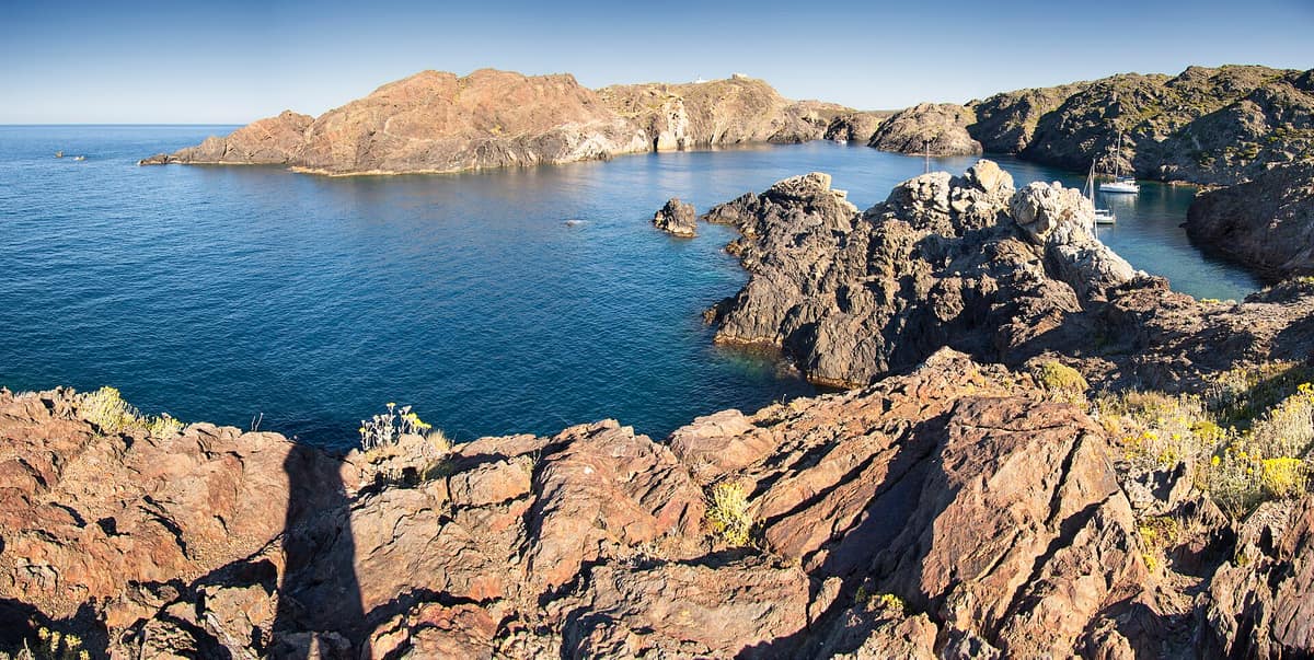
The easternmost point of the Iberian Peninsula, where the Pyrenees plunge into the sea in a labyrinth of metamorphic schists sculpted by the tramontana.
At Cap de Creus, the wind is an ever-present force. The relentless tramontana shapes the vegetation, dries the air, and saturates the soil with salt; where it blows hardest, the coast has been stripped down to bare rock cliffs. It marks the northeasternmost point of the Iberian Peninsula, and the Cap de Creus Natural Park, established in 1998, was the first maritime-terrestrial park in Catalonia: spanning 13.886 hectares, with 10.813 on land and 3.073 at sea.
What makes it unique
Here grows Seseli farrenyi, a plant found nowhere else in the world.
The place
Nature
The landscape
The Rodes or Verdera mountain range rises between Roses and Llançà, dropping into a coastal ribbon of cliffs sculpted by the sea and the tramontana. Inland, most of the terrain is carpeted in heathlands and dry grasslands, contrasting sharply with the bareness of the shoreline.
The origin dates to the Paleozoic era. Cap de Creus belongs to the axial zone of the Pyrenees, along with the Canigó, Pica d'Estats, Val d'Aran, and Cerdanya, safeguarding some of the oldest rocks of the mountain range's backbone. During the Hercynian orogeny, schists, gneisses, and marbles took shape, alongside granodiorite intrusions around Roses. Much later, volcanic activity from La Garrotxa left the basalt formations of Puig Ferral and Cap Norfeu.
Human intervention has left a deep mark. Much of the land consists of vast abandoned vineyards terraced with dry-stone walls, while grazing and recurring wildfires have shaped the open landscape. Today, Mediterranean maquis and scrubland dominate, featuring mastic, prickly juniper, tree heath, rockroses, and black gorse. Trees occupy little space: Aleppo pine and cork oak are most common, while holm oak and downy oak appear in shaded hollows.
The park also reaches underwater. Meadows of Posidonia, Cymodocea, and Zostera flourish over sandy and muddy sea bottoms and are strictly protected. The marine protected area spans some 3.000 hectares, representing 22 % of the park, extending from Cala Tamariua in El Port de la Selva to Punta Falconera in Roses.
Wildlife and seasons
If you want to observe birds, visit in spring or autumn during seasonal migration: Cap de Creus is an exceptional vantage point. Along the cliffs you can spot Bonelli's eagle, the peregrine falcon, and the Eurasian eagle-owl. Marine birds include gulls, the European shag, shearwaters, terns, and northern gannets.
On land, amphibians thrive, from the Mediterranean tree frog to the common toad. Hermann's tortoise and the Spanish pond turtle inhabit the area, though scarce, while the Iberian green lizard and common wall gecko are seen more easily. Among protected invertebrates, an endemic land snail, Mastigophallus rangianus, stands out.
Beneath the surface, marine life flourishes thanks to clean waters: red coral, gorgonian sea fans, spiny lobsters, and fish such as white seabream, saddled seabream, salema, red scorpionfish, and dusky grouper. The common bottlenose dolphin also frequents coastal waters.
Species
With a page in the atlas
Being mentioned in a source doesn't guarantee sightings: check with the people who manage the area.
Memory and protection
History and conservation
The Serra de Rodes and Cap de Creus have been inhabited since the Paleolithic. Heritage includes chapels, dry-stone walls, shepherd shelters, and archaeological remains with dolmens. Today's landscape inherits agricultural clearings begun at the end of the first millennium, while Cadaqués and Portlligat bear the indelible mark of Salvador Dalí, who attracted Federico García Lorca, Buñuel, Magritte, and Éluard.
The park's establishment protected a landscape scarred by disused quarries, reforestations, military barracks on El Pení, and secondary holiday homes. These traces intermingle with ancient terraces and the footpaths you tread today.
Before you set off
Visiting
How to visit
The park features walking itineraries. The circular Punta del Cap de Creus trail covers 2,1 km, with 100 metres of elevation change taking 45 minutes, rated easy. The Cap Norfeu circuit is another easy option: 4,6 km, 180 m of elevation gain, taking 1 h 45 min. For greater effort, the hike up Puig Ferral is moderate, spanning 6,9 km and 220 m of ascent, while the crossing from Cadaqués to Cap de Creus covers 9,2 km with 235 m of ascent and 165 m of descent. The most challenging route runs from Roses to Cadaqués: 20,4 km, 695 m of ascent, taking roughly 8 hours.
Punta de Cap de Creus and Cap Norfeu are integral natural reserves—the highest tier of legal protection for geological, botanical, and scenic wealth—where walking is restricted exclusively to signposted trails. The lighthouse viewpoint, facing southwest, commands vistas toward Illes d'en Forcat, Cap Norfeu, Cadaqués, and El Pení, overlooking coastal scrub.
The sea can be experienced through snorkelling at Cala Murtra, Cala Tamariua, and Cala Es Caials, supported by identification sheets; the park also designates scuba diving routes.
Before you go
Motor vehicle access (cars and motorbikes) to Punta de Cap de Creus is restricted with video monitoring on designated days; in 2026, daily in July and August from 9:30 to 21:30 h along the road between Cadaqués and the lighthouse. During restriction days, free parking is available at Corral d'en Morell in Cadaqués, from where shuttle buses run to the Punta. Vehicle access with four or more wheels to the coves of Roses is also regulated between 1 July and 31 August along the Montjoi and Jóncols road. Under Level 4 of the Alfa Plan for wildfire risk, access to the natural park is shut. These dates apply to 2026; check regulations for the year of your trip. Visiting in spring or autumn also avoids the midsummer crowds of July and August.
Check access, rules and visiting conditions in the official information from the managing body before you set off.
Location
Where it is and how far it reaches
Boundary of Cap de Creus · IUCN Ia · © EEA, CDDA (CC-BY) The coordinate is estimated; it isn't a verified access point.
Transparency
Sources
The research data with its sources, and the official links for this place, are in the Spanish version of this page. See the Spanish version
Around it
Nearby lies the Parc Natural dels Aiguamolls de l'Empordà.
Further away, Parc national de Port-Cros and Park prirode Lastovsko otočje share species like the bottlenose dolphin with Cap de Creus.
What else to explore nearby
Approximate straight-line distance between the edges of each area. It doesn't indicate access, routes or driving times.
- Aiguamolls de l'Empordà Natural Park
Catalonia (Girona / Castelló d'Empúries / Sant Pere Pescador)
About 10 km away
Coastal wetland and fluvial marsh reserve at the mouths of the Muga and Fluvià rivers on the Costa Brava.
JFMAMJJASONDMarch – May · September – November · Crowding low
If you like this place, elsewhere in Europe
Distant places with uncommon wildlife and habitats in common. The most widespread species don't count. Sharing species doesn't imply a corridor or guaranteed presence.
- Mondragó Natural Park
Balearic Islands (Mallorca / Santanyí)
In common: Tarentola mauritanica · Pinus halepensis · European shag — wild coast
White-sand coves nestled between coastal juniper groves, wild olive ravines and the freshwater wetlands of Ses Fonts de n’Alis.
JFMAMJJASONDApril – June · September – October · Crowding moderate
- Kornati National Park
Šibenik-Knin (Kornati Archipelago — Murter)
In common: European shag · Posidonia oceanica · Common bottlenose dolphin — wild coast, marine
A labyrinth of nearly ninety barren limestone islands, featuring sheer sea cliffs ("crowns") plunging into the open Adriatic.
JFMAMJJASONDMay – June · September – October · Crowding moderate
- Lastovo Archipelago Nature Park
Dubrovnik-Neretva (Lastovo Island)
In common: Pinus halepensis · Yelkouan shearwater · Posidonia oceanica — wild coast, marine
One of Croatia's most remote inhabited islands and dozens of islets, with pristine night skies and largely undisturbed seabed ecosystems.
JFMAMJJASONDMay – June · September – October · Crowding very low
- Port-Cros National Park
Provence-Alpes-Côte d'Azur (Var / Hyères)
In common: Yelkouan shearwater · Posidonia oceanica · Common bottlenose dolphin — wild coast, marine
One of the oldest marine parks in Europe (1963): an island cloaked in Mediterranean forest and posidonia seabed protected for sixty years.
JFMAMJJASONDMay – June · September – October · Crowding moderate
Entry #505 of the original atlas.