Ordesa y Monte Perdido National Park
Parque Nacional de Ordesa y Monte Perdido
Aragon (Huesca / Torla / Broto / Fanlo / Bielsa / Escalona) · Spain
Photo: Nata Mostova · CC BY-SA 4.0 · Wikimedia Commons
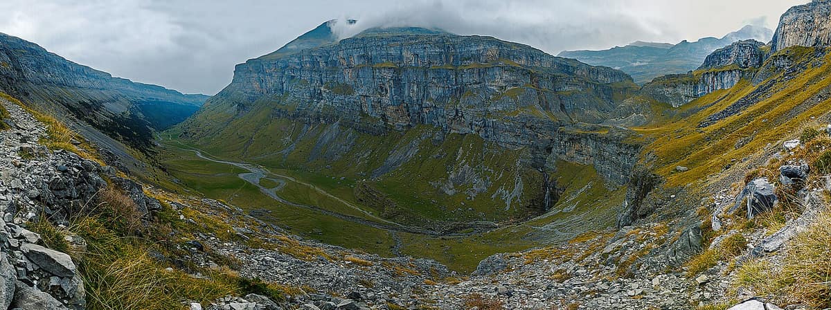
The 'Grand Canyon of Europe', UNESCO World Heritage Pyrénées-Mont Perdu, crowned by Monte Perdido (3,355 m) with four grand canyons: Ordesa, Añisclo, Escuaín, and Pineta.
According to legend, a knight hard-pressed by his foes raised his sword Durandarte and cleaved the rock wall blocking his retreat: thus the Brèche de Roland was opened. Whatever its true geological genesis, the cliff endures, and the national park surrounding it possesses the atmosphere of a mythic stage. Ordesa y Monte Perdido National Park occupies the Huesca Pyrenees, spanning from 700 m along the Bellós river to 3348 m atop Monte Perdido, encompassing four starkly distinct valleys: Ordesa, Añisclo, Escuaín, and Pineta. It was designated a Biosphere Reserve in 1977 and a UNESCO World Heritage site in 1997.
What makes it unique
Within a single park you transition from lush beech and fir valley forests to the highest limestone massif in Europe, illustrating pivotal stages of Pyrenean orogeny.
The place
Nature
The landscape
It all began with an ocean of limestone. The primary structure emerged during the Tertiary Alpine folding, later sculpted by Quaternary glaciation into monumental cirques and troughs. Hence the Ordesa valley boasts a dramatic U-shaped cross-section, carved by the Arazas down to its meeting with the Ara; hence the Tres Sorores massif stands as the highest limestone massif in Europe; and hence a lingering, retreating glacier clings to the northern face of Monte Perdido.
Then came moving water, dissolving the carbonate rock. High above, beyond 2000 m, the karst network swallows rainfall, leaving barren, arid summit crests. Below, the subterranean torrents re-emerge in thundering cascades, gorges, and canyons. The crystal-clear Arazas, teeming with trout, cascades through stepped waterfalls, with the Cola de Caballo and Gradas de Soaso among its most famed features. Añisclo is a canyon of 21 km where the Bellós courses between cliffs exceeding 1,000 m in vertical drop. In Escuaín, the Yaga carves through a subterranean karst gorge dotted with caverns. In Pineta rises the Cinca, fed by snowfields and the ice of Ibón de Marboré.
Vegetation arranges itself into distinct life zones. The montane belt, between 800 and 1700 m, shelters beechwoods, silver firs, and Scots pines; up to 2000 m, mountain pine takes command. In subalpine pastures blooms the iconic edelweiss. Clinging to limestone bluffs are specialized Pyrenean endemics: the park's flora counts 1400 species, nearly 45 % of all plants found in the Aragonese Pyrenees.
Wildlife and seasons
Cast your eyes toward the cliffs. The bearded vulture frequents high ravines and crags, nesting commonly along the Escuaín gorge. Alongside it soar the golden eagle, griffon vulture, Egyptian vulture, kites, and short-toed snake eagles. Ancient forests shelter the western capercaillie, boreal owl, black woodpecker, and white-backed woodpecker.
Across high subalpine pastures, alpine marmots and Pyrenean chamois (known locally in Aragon as sarrios) are readily spotted. The chamois population stands around 700 individuals, having declined due to outbreaks of keratoconjunctivitis and pestivirus. Red deer are gradually expanding back into the Pyrenean valleys, while the brown bear, numbering between 25 and 32 individuals across the entire range, roams secluded sectors. Small mammals include otters, foxes, wildcats, and the Pyrenean desman. Pristine glacial torrents shelter the endemic Pyrenean frog and the Pyrenean brook salamander, both sensitive biological indicators.
Each season transforms the park. In spring, the hunters' path (Senda de los Cazadores) and Faja de Pelay are frequently closed by residual ice, rockfalls, and fallen timber, while the Bellós swells with turbulent snowmelt. Autumn provides the grand spectacle: from mid-October onward the deciduous woodlands of Ordesa explode with golden foliage, while in Añisclo beeches, maples, and ashes reach their peak between late October and early November.
Species
With a page in the atlas
Being mentioned in a source doesn't guarantee sightings: check with the people who manage the area.
Memory and protection
History and conservation
This region remained secluded until modern times, conserving traditional architecture, land stewardship, and pastoral customs. For centuries, shepherds from Torla, Gavarnie, Barèges, and Broto negotiated shared grazing rights: flocks moved to lowlands in winter and summered on alpine passes. In the Turieto woods, a monument honours pioneer mountaineer Lucien Briet, who hailed the valley as a jungle where one sees only trees, through trees, and above trees.
The national park was established in 1918. In the late 70s, local communities and institutions mobilised successfully to halt a proposed hydroelectric dam that would have drowned the Añisclo Canyon. In Añisclo, visitors reach the cave hermitage of San Úrbez via a vertiginous bridge anchored between cliffs high above the Bellós river.
Before you set off
Visiting
How to visit
Each valley offers its own gateway. Access Ordesa from Torla, Añisclo from Escalona, Escuaín through Escuaín or Tella, and Pineta via Bielsa. Start at a visitor centre: the Torla-Ordesa centre preserves the mount of Celia, the last Pyrenean ibex before its extinction; other facilities operate at Casa Oliván and Tella, complemented by information desks in La Pradera, Escalona, San Úrbez, Fanlo, Escuaín, Bielsa, and Pineta.
In Ordesa, the information post at La Pradera marks the trailhead for hikes to the Arazas waterfalls, the Cola de Caballo, the Senda de los Cazadores, and the elevated Faja de Pelay ledge. The hunters' trail climbs to Calcilarruego viewpoint, providing access to the breathtaking cornice above the Arazas canyon.
Alternative valleys offer distinct charms: in Escuaín, follow the cliff viewpoint path from the village to overlook the gorge, or walk to the Angonés viewpoints from Revilla. From Pineta, summer tracks climb to the Balcón de Pineta and Ibón de Marboré, routes demanding solid physical stamina and mountain gear. Escuaín's southern orientation brings fewer frosts and earlier snowmelt.
Before you go
During high season, private vehicles are barred from driving up to the Pradera de Ordesa: you must board the shuttle bus from Torla-Ordesa. Since 9 February 2022, bivouacking is strictly forbidden across the entire Ordesa sector; overnight camping is restricted to the designated zone at Góriz with prior booking. Inside the park you may not light fires, allow dogs off leash, or collect animals, plants, minerals, or rocks.
Check access, rules and visiting conditions in the official information from the managing body before you set off.
Location
Where it is and how far it reaches
Boundary of Ordesa y Monte Perdido · IUCN II · © EEA, CDDA (CC-BY) The coordinate is estimated; it isn't a verified access point.
Transparency
Sources
The research data with its sources, and the official links for this place, are in the Spanish version of this page. See the Spanish version
Around it
Just 1 km away across the border lies Parque Nacional de los Pirineos. Farther afield, Parque Nacional de los Picos de Europa shares the chamois, alpine crags, deep gorges, and glaciated karst massifs, while Parco Nazionale Gran Paradiso shares the bearded vulture and golden eagle alongside glacial high-mountain terrain.
What else to explore nearby
Approximate straight-line distance between the edges of each area. It doesn't indicate access, routes or driving times.
- Pyrénées National Park
Occitanie / Nouvelle-Aquitaine (Hautes-Pyrénées / Pyrénées-Atlantiques)
About 1 km away
The French slope of the central Pyrenees, twin to Ordesa: glacial cirques, bearded vultures, isards, and Pyrenean desmans.
JFMAMJJASONDJune – September · Crowding moderate
If you like this place, elsewhere in Europe
Distant places with uncommon wildlife and habitats in common. The most widespread species don't count. Sharing species doesn't imply a corridor or guaranteed presence.
- Bucegi National Park - Western Slopes
Dâmbovița, Argeș, and Prahova Counties
In common: Leontopodium alpinum · Silver fir · Golden eagle — high mountain, karst and caves, old-growth forest
Dramatic conglomerate cliffs rising toward the plateau of the Babele and Sphinx wind-sculpted rock formations.
JFMAMJJASONDJune – October · Crowding low
- Vanoise National Park
Auvergne-Rhône-Alpes (Savoie)
In common: Leontopodium alpinum · Bearded vulture · Golden eagle — high mountain, glacial landscape
France's first national park (1963), created to save the Alpine ibex: glaciers, alpine grasslands, and one of the Alps' greatest ibex populations.
JFMAMJJASONDJune – September · Crowding moderate
- Pelister National Park
Pelagonia (Bitola / Resen)
In common: Bearded vulture · Silver fir · Golden eagle — high mountain, glacial landscape
The oldest national park in North Macedonia (1948), established to preserve primeval Macedonian pine (molika) forests.
JFMAMJJASONDJune – October · Crowding very low
- Abruzzo, Lazio and Molise National Park
Abruzzo, Lazio and Molise regions (L'Aquila, Frosinone and Isernia provinces)
In common: Pyrenean chamois · Bearded vulture — high mountain, karst and caves
Sanctuary of the Marsican brown bear and Apennine wolf in primeval beechwoods and high alpine valleys of central Italy.
JFMAMJJASONDMay – June · October · Crowding moderate
Entry #492 of the original atlas.