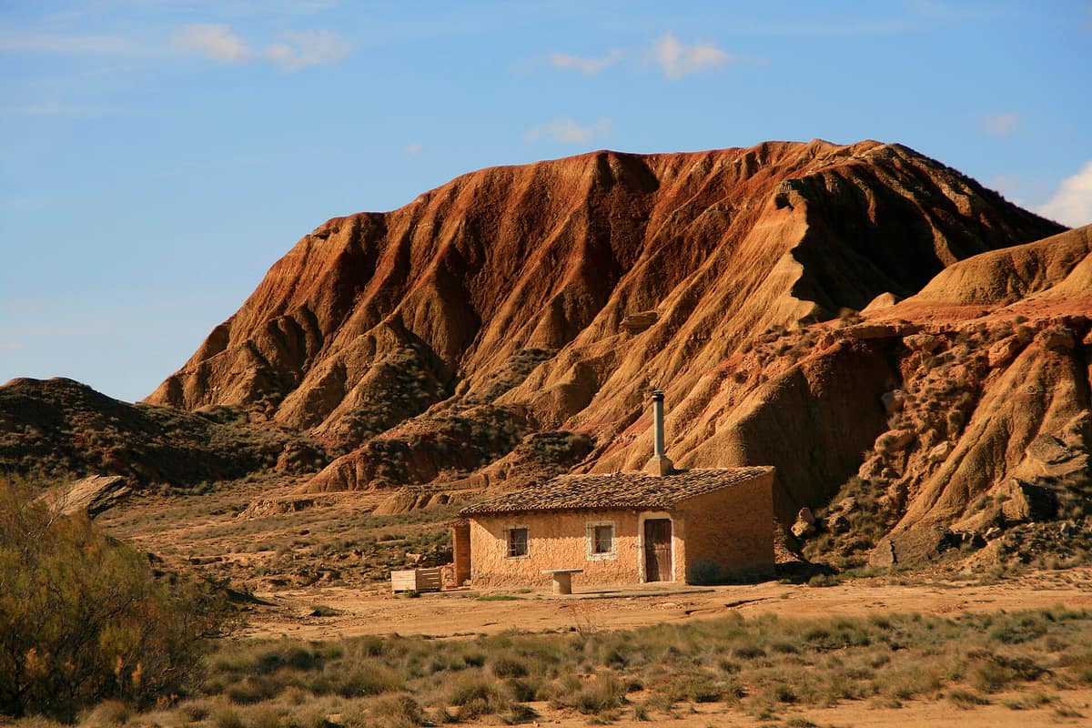
Bardenas Reales de Navarra Natural Park
Parque Natural Bardenas Reales de Navarra
Navarra (Tudela / Arguedas / Valtierra) · Spain
Photo: Miguel Ángel García. from Ólvega., España · CC BY 2.0 · Wikimedia Commons
Desert and badlands landscape of 42,000 ha carved into clays, gypsum, and sandstones, crowned by iconic isolated buttes like Castildetierra.
Roughly ten million years ago, the Ebro basin was an immense inland lake. Eventually it breached to the Mediterranean, the lake drained, the modern Ebro formed, and unrelenting erosion commenced. What you see today in the Bardenas Reales de Navarra is the breathtaking outcome: flat-topped plateaus, solitary buttes, and deeply incised ravines carved from soft sediments in southeastern Navarra. It is a Natural Park and Biosphere Reserve, designated on 7 November 2000, spanning 39,285.30 ha. Despite its northern latitude, it features a semi-arid climate, heavily eroded badlands, and elevations between 280 and 659 m. About half the expanse is farmed, with the remainder supporting low pseudo-steppe scrub.
What makes it unique
Here fragile clay melts beneath a protective caprock while ongoing erosion sculpts stark buttes before your eyes, beneath skies sheltering exceptional steppe and raptor communities.
The place
Nature
The landscape
The geomorphology is straightforward: weak sediments (marls, clays, silts, and gypsum) lie in near-horizontal strata, leaving them vulnerable to rapid, fierce erosion. In tabular erosion, the hard upper caprock resists while the soft underlying layers undermine, until the rim suddenly shears away. This process yields elevated plateaus, known as planas, and tabular buttes (cabezos), among which El Rallón, Pisquerra, Cortinas, and Castildetierra stand out. Runoff finishes the task: it flutes clay banks into elephant-skin badlands and bores out sinkholes and dry gully canyons.
The territory divides into three distinct zones. La Blanca is a vast central depression, framed by El Plano to the north and the stepped plateaus of La Negra to the south. In La Blanca you will encounter dry steppes, esparto grasslands, wormwood, and saltwort; La Negra, by contrast, preserves Aleppo pine woodlands growing alongside Phoenician juniper, kermes oak, lentisc, and hawthorn.
The most delicate flora thrives in the salt flats of the ravines and saline basins of La Blanca: only specialized halophytes endure such saline soils, representing the most botanically significant plant communities in the park.
Climate completes this desert tableau. The dry season is prolonged, marked by scorching summers and freezing winters; spring is ephemeral, while autumn is generally the pleasantest season provided the cierzo is quiet—a cold, dry northwesterly wind that typically blows between 20 and 30 km/h.
Wildlife and seasons
The Bardenas are above all a sanctuary for birds. Breeding species alone exceed one hundred, with raptor and steppe bird guilds ranking among the richest in Europe. The Egyptian vulture, griffon vulture, and Eurasian eagle-owl are hallmark raptors. In the Rincón del Bú, a compact reserve of 460 ha, the golden eagle and Egyptian vulture nest alongside the stone-curlew and Dupont's lark, famed for its eagle-owl breeding population.
Among steppe specialists, the great bustard is nearly extinct here, the little bustard numbers around twenty pairs, the Eurasian stone-curlew remains abundant, and Dupont's lark totals roughly 250 pairs. The Caídas de la Negra escarpment shelters eagles, vultures, owls, bustards, red foxes, European wildcats, common genets, amphibians, and reptiles; among the latter are the Spanish terrapin, ocellated lizard, Iberian wall lizard, and large psammodromus.
Plan your journey around the seasons: spring passes swiftly, and autumn without cierzo winds offers the most comfortable excursion conditions.
Species
With a page in the atlas
Being mentioned in a source doesn't guarantee sightings: check with the people who manage the area.
Memory and protection
History and conservation
Human presence in the Bardenas peaked during the Bronze Age four thousand years ago, followed by some twenty centuries devoid of permanent settlements. Yet the territory was never vacant: in the year 882 the Roncal Valley was granted the first recorded royal grazing concession, inaugurating historic seasonal transhumance. Flocks arrived in early autumn and stayed until late spring, when snow melted from high Pyrenean pastures. In 1,705, a royal decree issued by Philip V ratified perpetual communal rights for twenty-two governing entities: nineteen towns, two Pyrenean valleys, and a Cistercian monastery.
Rincón del Bú and Caídas de la Negra were established as strict nature reserves in 1986, and in 1999 nearly the entire territory became a natural park. Its wilderness value lies in its high degree of naturalness, with twenty-seven bird species depending on strict habitat management. Within the perimeter, outside reserve zones, an air force firing range has operated since 1,951. Traditional agro-pastoral communities work together to balance farming and wildlife conservation.
Before you set off
Visiting
How to visit
The Bardenas Information Centre, located at Los Aguilares estate, has stood at the threshold of the park since summer 2010. Access to both the visitor centre and the reserve begins off the NA-134 highway at km 15.1 (Tudela-Arguedas route).
Designated tracks are explored on foot or by mountain bike. On foot, highlights include the Barranco de las Cortinas, Cabezo de las Cortinillas, and El Fraile; by mountain bike, routes loop across El Plano, around the Ferial reservoir, and over Plana de la Negra. Park regulations permit walking along approved hiking itineraries as well as vehicle-grade dirt roads and trails, observing wildlife along open routes while respecting zoned restrictions. Nature photography and filming are welcome for recreation or education, provided wildlife is not disturbed. Supervised bird photography sessions previously held at the Mainate scavenger feeding station are temporarily suspended following damage in a brush fire.
Follow posted rules and keep your exploration within designated boundaries.
Before you go
Walk only along designated trails, dirt tracks, and open roadways, and do not disturb wildlife when taking photographs or video. Photographic sessions at the Mainate hide remain suspended.
Check access, rules and visiting conditions in the official information from the managing body before you set off.
Location
Where it is and how far it reaches
Boundary of Bardenas Reales · IUCN II · © EEA, CDDA (CC-BY) The coordinate is estimated; it isn't a verified access point.
Transparency
Sources
The research data with its sources, and the official links for this place, are in the Spanish version of this page. See the Spanish version
Around it
Further afield, Reserva Natural Dirigida de la Laguna de Gallocanta shares steppe habitats with Dupont's lark, little bustard, and black-bellied sandgrouse; Réserve Naturelle Nationale de la Coussoul de Crau shares the little bustard and sandgrouse; and Parque Natural Hoces del Río Duratón gathers Egyptian vultures, eagle-owls, and griffon vultures among rocky gorges.
If you like this place, elsewhere in Europe
Distant places with uncommon wildlife and habitats in common. The most widespread species don't count. Sharing species doesn't imply a corridor or guaranteed presence.
- Gallocanta Lagoon Nature Reserve
Aragon / Castilla-La Mancha (Zaragoza / Teruel — Gallocanta / Bello)
In common: Dupont's lark · Pin-tailed sandgrouse · Little bustard — steppe and grassland
Western Europe's largest saline lagoon and the Iberian Peninsula's foremost stopover for the common crane.
JFMAMJJASONDOctober – March · Crowding low
- Coussouls de Crau National Nature Reserve
Bouches-du-Rhône (Arles / Saint-Martin-de-Crau)
In common: Pin-tailed sandgrouse · Little bustard — steppe and grassland
The only genuine pebble steppe in Northern and Central Europe (Coussoul), an ancient fossil delta of the Durance river.
JFMAMJJASONDApril – June · September – October · Crowding very low
- Montsant Natural Park
Catalonia (Province of Tarragona / Priorat comarca)
In common: Egyptian vulture · Griffon vulture · Eurasian eagle-owl — karst and caves, gorge and canyon
A range of limestone-conglomerate ramparts, gorges and Mediterranean forest inhabited by Bonelli's eagle and Iberian ibex.
JFMAMJJASONDMarch – June · September – November · Crowding low
- Verdon Regional Natural Park - Grand Canyon
Alpes-de-Haute-Provence / Var (Castellane / Moustiers-Sainte-Marie)
In common: Egyptian vulture · Griffon vulture · Eurasian eagle-owl — karst and caves, gorge and canyon
The 'Grand Canyon of Europe', sheer limestone cliffs plunging 700 m carved out by the turquoise waters of the Verdon River.
JFMAMJJASONDApril – June · September – October · Crowding moderate
Entry #501 of the original atlas.