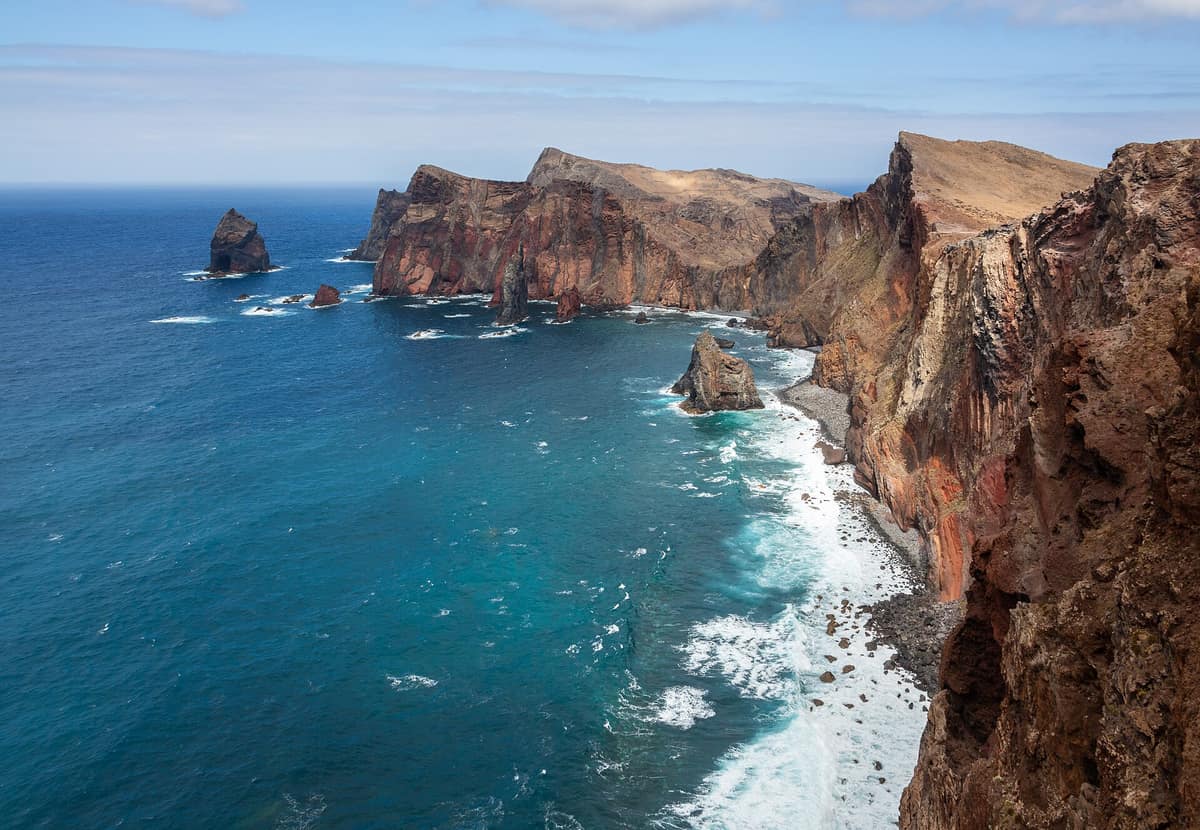
Ponta de São Lourenço Nature Reserve
Reserva Natural da Ponta de São Lourenço
Autonomous Region of Madeira (Madeira Island / Caniçal / Machico) · Portugal
Photo: Diego Delso · CC BY-SA 4.0 · Wikimedia Commons
Narrow, arid volcanic peninsula at the eastern tip of Madeira with red and black tuff cliffs and a haven for the Mediterranean monk seal (Monachus monachus).
Madeira ends in a barren peninsula. Arriving at Ponta de São Lourenço, the trees vanish in stark contrast to the rest of the island: what remains is a nine-kilometre ridge of volcanic rock, low vegetation, and wind ending at the islets of Desembarcadouro and Farol. The low vegetation is no accident; it is the natural consequence of aridity and relentless north winds. It was also the first sight that greeted Portuguese navigators when they sighted the island in 1419: the very first slice of land to rise on the horizon, named after the vessel that carried its discoverer.
What makes it unique
A barren, windswept volcanic end of the island where protected seabirds nest and, with some luck, the Mediterranean monk seal can be spotted.
The place
Nature
The landscape
The peninsula is volcanic in origin, composed mainly of basalt alongside scattered calcareous sediments. Pyroclastic rocks and basalt dykes abound, with formations dating back to the Late Pleistocene, some 100,000 years ago. Its highest point is Pico do Furado.
To the west, Baía d'Abra, wide and offering sheltered anchorage, marks the start of the footpath. Beyond the Quinta do Lorde marina lies Prainha, a small dark-sand beach beneath Morro da Piedade, a volcanic cinder cone crowned by a sixteenth-century chapel. North of Prainha spread the Dunas da Piedade, a fossil dune system preserving Quaternary fossils 300 thousand years old—unique records in Europe, with calcified root structures.
The natural vegetation consists of annual and biennial herbs, sparse shrubs, and exceedingly rare dwarfed trees. Around 160 plant species grow here: 141 on the peninsula itself and 71 on the islet of Desembarcadouro. Notable endemics include estreleira, perpétua, and vaqueira; Matthiola maderensis, Echium nervosum, and Andryala glandulosa also flourish. The islet of Desembarcadouro is the last pristine haven of indigenous Madeiran coastal flora, marked by sprawling carpets of trevina.
Wildlife and seasons
Seabirds are the most conspicuous inhabitants. Protected species nest along the ledges, including Cory's shearwater, Bulwer's petrel, band-rumped storm-petrel, and common tern. The islet of Farol is free of terrestrial predators, making it an undisturbed haven for nesting seabirds. On Desembarcadouro, where rats are present, nesting is tougher, yet it hosts one of the region's largest colonies of yellow-legged gull. The area is designated an Important Bird Area for its seabird colonies, harboring Madeira's largest colony of Caspian gulls.
Among land birds, Berthelot's pipit and European goldfinch are common, while raptors include common buzzard (manta), common kestrel, and barn owl. Many migratory birds make stopovers here, with the whimbrel being especially typical. The reserve is home to 35 species of terrestrial molluscs, 24 of which are endemic, while the Madeiran wall lizard is an abundant native vertebrate.
Beneath the surface, sea cucumbers and sea urchins coat the rocky seafloors. Prominent fish include white seabream, damselfish, and parrotfish. Sea turtles and several marine mammals frequent these coastal waters, including dolphins and the iconic lobo-marinho, the Mediterranean monk seal.
Species
With a page in the atlas
Being mentioned in a source doesn't guarantee sightings: check with the people who manage the area.
Memory and protection
History and conservation
The regional government purchased the islet of Desembarcadouro and the far tip of the peninsula up to the stone wall of Baía d'Abra in 1994. Casa do Sardinha was built by Manuel Bettencourt Sardinha after he constructed Cais de Abra, intended as a retreat and summer home; in 1996 his granddaughter sold it to the Autonomous Region of Madeira on the condition that it serve the conservation of the area's natural values.
Ponta de São Lourenço is a Natural Monument within Madeira's monument network and part of the Natura 2000 network as a Special Area of Conservation. The management zoning establishes total protection areas (the islets), partial protection (the peninsula), and complementary zones (beaches, viewpoints, and the Chapel of Piedade).
Before you set off
Visiting
How to visit
The trail is the Vereda da Ponta de São Lourenço. It begins at Baía d'Abra, reached via the regional road 109, and ends at Cais do Sardinha. The hike takes about 2 hours over approximately 4 km; it is easy to walk and recommended throughout the year. Those seeking an interpretive tour can request a guided visit accompanied by a park technician.
At the end of the trail by Cais do Sardinha stands the Casa do Sardinha Visitor Reception Centre, featuring a permanent exhibition on the protected area. It served as an observation and surveillance post until 2009. Environmental education activities are run through the Núcleo dos Dragoeiros das Neves Information Centre.
Before you go
Spending the night within the protected area requires prior authorization from the Instituto das Florestas e da Conservação da Natureza. An entry fee applies for visitors older than 12; check the current conditions with the park administration before going.
Check access, rules and visiting conditions in the official information from the managing body before you set off.
Location
Where it is and how far it reaches
Boundary of Monumento Natural da Ponta de Sao Lourenco · IUCN III · © EEA, CDDA (CC-BY) The coordinate is estimated; it isn't a verified access point.
Transparency
Sources
The research data with its sources, and the official links for this place, are in the Spanish version of this page. See the Spanish version
How it fits into the territory
Calculated from the Atlas boundaries. «Part of» is only stated with an official boundary; an estimated area only means that they overlap.
Around it
The Reserva Natural da Rocha do Navio lies six kilometres away, Pico Ruivo y Macizo Central de Madeira eight, and the Islas Desertas fifteen. All three share the same volcanic origins with Ponta de São Lourenço. Ponta de São Lourenço is incorporated into the broader Parque Natural de la Madeira.
What else to explore nearby
Approximate straight-line distance between the edges of each area. It doesn't indicate access, routes or driving times.
- Desertas Islands Nature Reserve (Madeira)
Autonomous Region of Madeira (Deserta Grande / Bugio / Ilhéu Chão)
About 15 km away
Uninhabited archipelago of three narrow volcanic islands (Deserta Grande, Bugio, and Chão), a strict sanctuary for the Mediterranean monk seal (Monachus monachus).
JFMAMJJASONDMay – September · Crowding none
If you like this place, elsewhere in Europe
Distant places with uncommon wildlife and habitats in common. The most widespread species don't count. Sharing species doesn't imply a corridor or guaranteed presence.
- Akamas Peninsula
Cyprus (Paphos — Polis / Latchi)
In common: Mediterranean monk seal — wild coast, marine
Mediterranean scrub and woodland, rugged gorges, and vital nesting beaches for green and loggerhead sea turtles in northwestern Cyprus.
JFMAMJJASONDApril – June · September – October · Crowding low
- Lastovo Archipelago Nature Park
Dubrovnik-Neretva (Lastovo Island)
In common: Mediterranean monk seal — wild coast, marine
One of Croatia's most remote inhabited islands and dozens of islets, with pristine night skies and largely undisturbed seabed ecosystems.
JFMAMJJASONDMay – June · September – October · Crowding very low
Entry #515 of the original atlas.